Showers/Storms Return Thursday Afternoon/Night
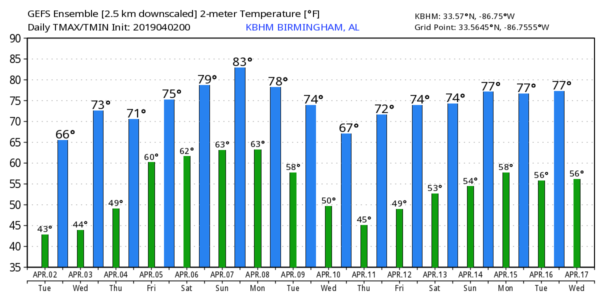
DRY THROUGH TOMORROW: An upper trough produced a few sprinkles across Alabama overnight, but as the wave moves on to the east, we expect a good supply of sunshine today with a high in the mid to upper 60s. Tomorrow will be sunny and warmer with a high in the mid 70s.
RAIN RETURNS: Clouds will increase Thursday, and we will have a round of showers and thunderstorms Thursday afternoon into Thursday night. For now it looks like the best chance of rain comes from about 3:00 p.m. Thursday through 8:00 a.m. Friday.
On their “Day Three” outlook for Thursday (which runs through 7:00 a.m. Friday), SPC has introduced the standard “slight risk” (level 2/5) of severe thunderstorms for extreme West Alabama, with a “marginal risk” (level 1/5) as far east as Tuscumbia, Birmingham, Montgomery, and Enterprise…
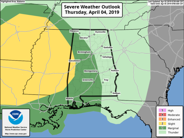
Severe thunderstorms are more likely west of Alabama Thursday, and with limited instability we believe the storms will be weakening as they move into our state late in the day and Thursday night. Still, some of the stronger storms could produce some hail, and strong gusty winds.
Rain ends early in the day Friday, and we could see some sun by Friday afternoon. Afternoon highs will hold in the 70s Thursday and Friday.
THE ALABAMA WEEKEND: Looks like it will be our warmest weekend so far this year with highs between 75 and 80 degrees. On Saturday, we expect a mix of sun and clouds with scattered showers and thunderstorms in a moist airmass. It won’t rain all day, but a passing shower or storm is very possible from time to time. Showers and thunderstorms become more numerous Sunday, especially during the afternoon hours and into Sunday night, ahead of an upper trough. With high instability values, we will need to be watch out for the potential for severe storms, but it is way too early to determine any specific risk for now.
NEXT WEEK: Rain tapers off Monday morning, and the middle of the week looks dry and a bit cooler… See the Weather Xtreme video for maps, graphics, and more details.
ON THIS DATE IN 1957: An EF-3 tornado tore through Dallas, Texas. 10 people were killed, and 216 were injured. Total damage was $4 million. This tornado was among the most photographed and studied in history. A second tornado developed just one mile east of the primary tornado. This tornado moved from northwest Dallas into Collin County, destroying farm homes.
IT’S THAT TIME AGAIN FOR INDYCAR AT BARBER: The Honda Indy Grand Prix of Alabama will be April 5-7 at the beautiful Barber Motorsports Park! Make plans for the event that has been voted “Best Annual Event” & “Best Sporting Event” in Birmingham. Kids 15 & under are admitted free with a ticketed adult, and three-day general admission tickets are $69. Single day tickets are as low as $15. Pack a picnic/cooler and bring the family out for a weekend full of activities and racing! For tickets, CLICK HERE.
BEACH FORECAST: Click here to see the AlabamaWx Beach Forecast Center page.
WEATHER BRAINS: Don’t forget you can listen to our weekly 90 minute show anytime on your favorite podcast app. This is the show all about weather featuring many familiar voices, including our meteorologists here at ABC 33/40.
CONNECT: You can find me on all of the major social networks…
Facebook
Twitter
Instagram
Pinterest
Snapchat: spannwx
I have a weather program this morning at Wellborn Elementary in Calhoun County… look for the next Weather Xtreme video here by 4:00 this afternoon. Enjoy the day!
Category: Alabama's Weather, ALL POSTS, Weather Xtreme Videos
About the Author (Author Profile)
James Spann is one of the most recognized and trusted television meteorologists in the industry. He holds the AMS CCM designation and television seals from the AMS and NWA. He is a past winner of the Broadcast Meteorologist of the Year from both professional organizations.Subscribe
If you enjoyed this article, subscribe to receive more just like it.


