The Noon Update: Mostly Dry Today Except Northwest; Storms Return Tonight/Monday, Some Could be Strong to Severe
It is a warm and fairly humid Sunday morning across all of Alabama. At least south of a stationary front that bisects the northwestern part of the state. To the north, temperatures are in the 60s and clouds are thick. To the south, readings are in the middle and upper 70s for the most part with partly cloudy to partly sunny skies. The mercury has already risen to 80F at Andalusia.
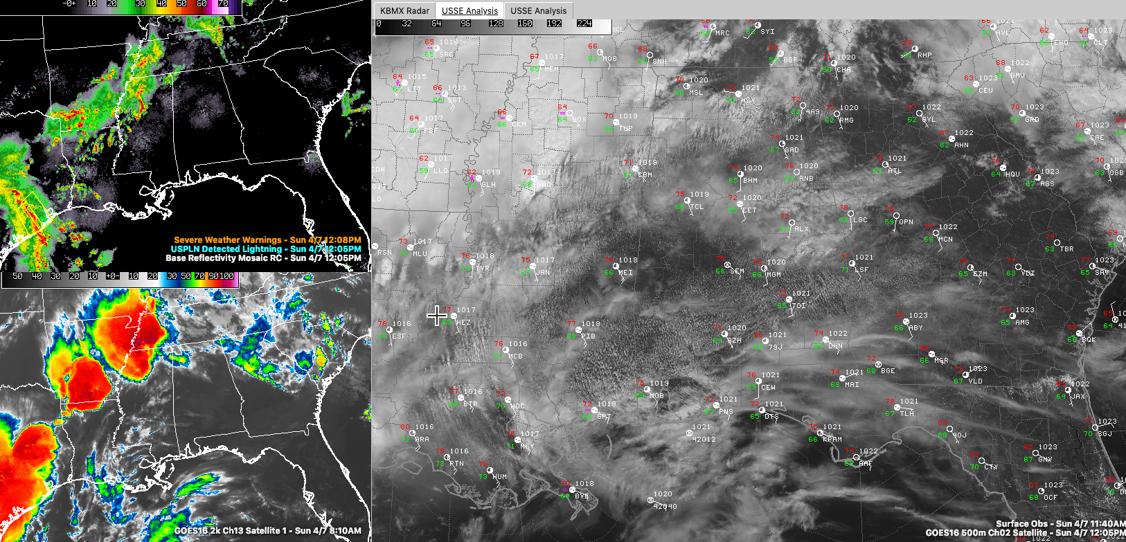
Stubborn high pressure centered off the Mid-Atlantic coast is keeping a broad, moist south-southeasterly flow in place Radars are quiet across Alabama, with widespread showers and storms to our north and west, extending from the Ohio Valley back through Tennessee, eastern Arkansas, northwestern Louisiana and into Central Texas. This activity is occurring in the battle zone between broad low pressure over the middle of the country and the moisture pump of a high to the east.
For the rest of today, Alabama will continue with that mix of sun and clouds. The band of showers to our northwestern will slowly sag southward, pushing showers and storms into the Northwest corner of the state. Most folks should remain dry through the afternoon elsewhere. Highs today will vary, ranging from the lower 70s over Northwest Alabama, to the upper 70s to lower 80s elsewhere.
HONDA WEATHER: It will be a perfect day for all the racing activities out at the beautiful Barber Motorsports Park in Leeds as the Honda Grand Prix of Alabama weekend continues today. Just dress for the warmth and take the sunscreen, please. And have a great time! It’s not too late to get your tickets… Make plans for the event that has been voted “Best Annual Event” & “Best Sporting Event” in Birmingham. Kids 15 & under are admitted free with a ticketed adult. Pack a picnic/cooler and bring the family out for a weekend full of activities and racing! For tickets, CLICK HERE.
TONIGHT: A surface low Is forming east of Corpus Christi on the Texas coast. This low will find the going slow as it tracks northeastward and then eastward across the Gulf States. Widespread strong to severe thunderstorm will accompany the low as it tracks toward Louisiana. The SPC has upgraded the severe weather risk for today over eastern Texas and much of Louisiana to Enhanced, or 3 of 5 on its scale. The slight risk area extends all the way into southern Kentucky, including the Northwest corner of Alabama. A marginal risk area covers areas generally along and north and west of I-59/US-43. The storms will reach the Mississippi River by 7 p.m. and they will clip the Northwest Corner of Alabama after midnight. Another batch of storms will approach western Alabama between 2-6 a.m. as well. Those storms will still be strong but should be slowly weakening. Lows will be in the 60s area-wide.
MONDAY’S SEVERE THREAT: As the trough presses eastward on Monday, the boundary left behind from tonight’s thunderstorm complex will energize with the heating of the day. Despite the presence of clouds and precipitation and weak overall wind fields, some of the storms tomorrow could become severe. Damaging winds will be the primary threat, but a few isolated tornadoes can’t be ruled out. It is a situation we will continue to watch closely for the rest of today and into tomorrow. The rain and storms should be into Georgia by early evening, but the trailing low will keep showers in the forecast through Tuesday morning as it slowly tracks across Alabama from west to east. Highs on Monday will be in the 70s.
REST OF THE WEEK: Wednesday looks nice with highs in the 80s and lots of sunshine. There could be a few showers on Thursday as a strong surface low over Kansas winds up, increasing our southerly winds. Highs will still be near 80F. Showers and storms arrive late Thursday night and Friday but they will be going downhill and severe weather is not expected. The weekend had looked nice, but recent model runs have trended it to wetter. Stay tuned.
Category: Alabama's Weather, ALL POSTS
About the Author (Author Profile)
Bill Murray is the President of The Weather Factory. He is the site's official weather historian and a weekend forecaster. He also anchors the site's severe weather coverage. Bill Murray is the proud holder of National Weather Association Digital Seal #0001 @wxhistorianSubscribe
If you enjoyed this article, subscribe to receive more just like it.


