A Few Showers Out There At Midday; Severe Storms Possible On Sunday
CONDITIONS AT 12:30 PM
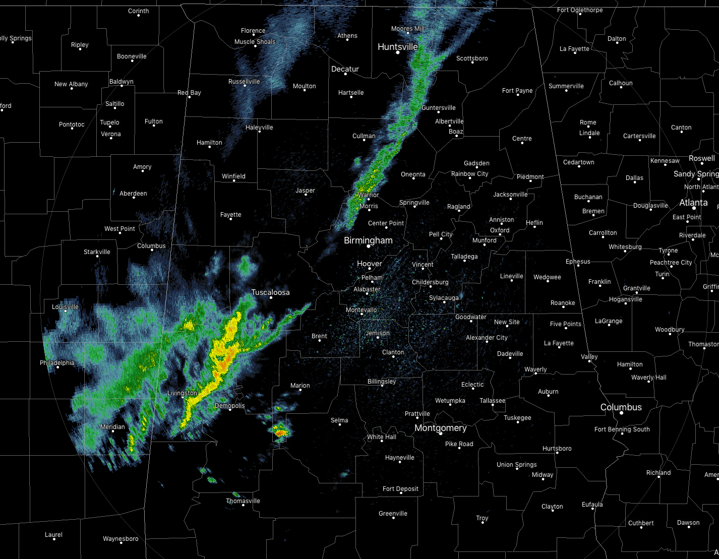
We have a surface boundary that is stalling out over portions of Central Alabama that has showers falling in a broken line from the northern parts of Cullman and Blount counties down through the northern parts of Jefferson County, then resuming over Tuscaloosa, Pickens, Sumter, Greene, and Hale counties. No lightning with these showers at the moment, but we may have some thunder possible as the daytime heating continues. Speaking of heating, temperatures are in the 60s and 70s across the area… as cool as 63 degrees in Haleyville and as warm as 79 degrees in Montgomery. Birmingham was at 75 degrees.
WEATHER FOR THE REST OF YOUR FRIDAY
A surface boundary will stall out across Central Alabama that will keep showers and a few thunderstorms possible mainly north of a line from Fort Deposit to Jacksons’ Gap to Roanoke. Rain chances increase from southeast to northeast, ranging from 20% to 60%. Skies will be mainly cloudy for the rest of the afternoon and evening hours and highs topping out in the lower 70s to the lower 80s across the area from northwest to southeast. For the late night and overnight hours, we’ll continue to have the possibility of showers and a few isolated thunderstorms across the same parts of the area with the same rain chances as the daytime hours. Lows will be down into the mid-50s to the mid-60s.
POTENTIAL FOR SEVERE STORMS THIS WEEKEND
A very dynamic system is expected to form out to our west that will bring the potential of severe storms to Central Alabama during the late night hours on Saturday and through the morning and into the afternoon hours on Sunday. This will need to be a system that is taken seriously and make sure that your family, friends, and neighbors know about the upcoming threat.
A warm front will be moving northward throughout Central Alabama during the early morning hours on Saturday that will bring some scattered showers and a few rumbles of thunder to the area during the morning hours, but much of the afternoon and into the evening hours will be mainly dry. A passing shower may be possible but they will be very few and far between. Skies will be mostly cloudy but there will be a few breaks in the clouds at times, especially during the afternoon. Highs will be in the mid-70s to the mid-80s across the area from northwest to southeast.
Saturday night through the overnight and into the early morning hours on Sunday is when we really need to be weather aware. There will be a main line of storms start to push into the western parts of Central Alabama in the 1:00 am to 3:00 am time frame, but we may have some supercells form out ahead of that and move in a little earlier. The main window for stronger to severe storms look to be from 12:00 am Sunday through 2:00 pm on Sunday afternoon.
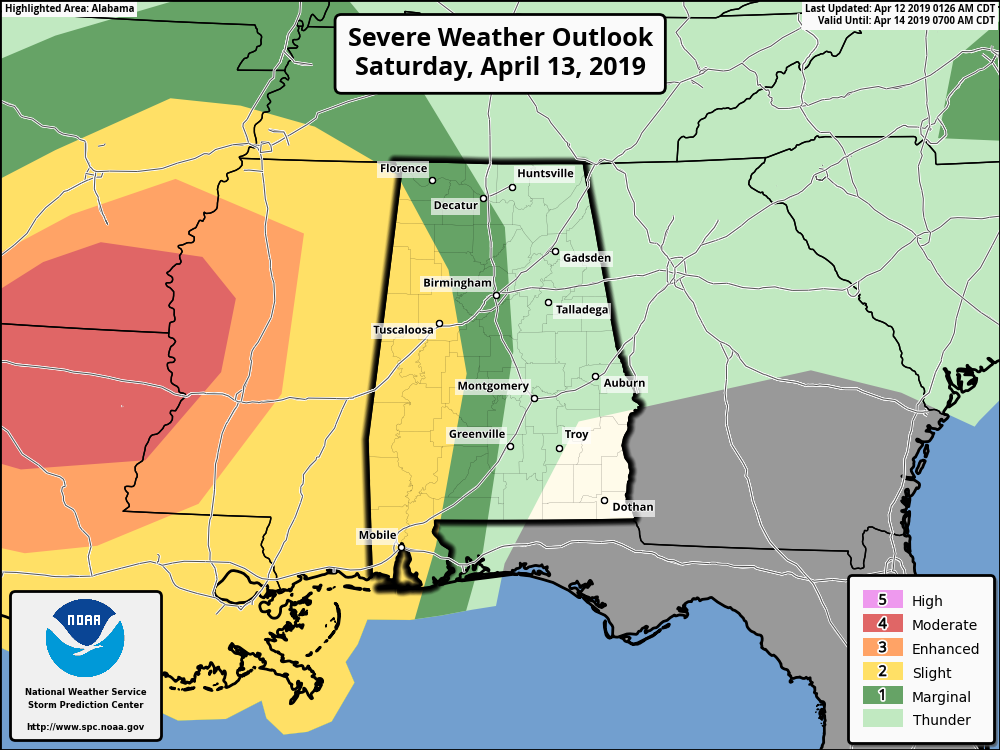
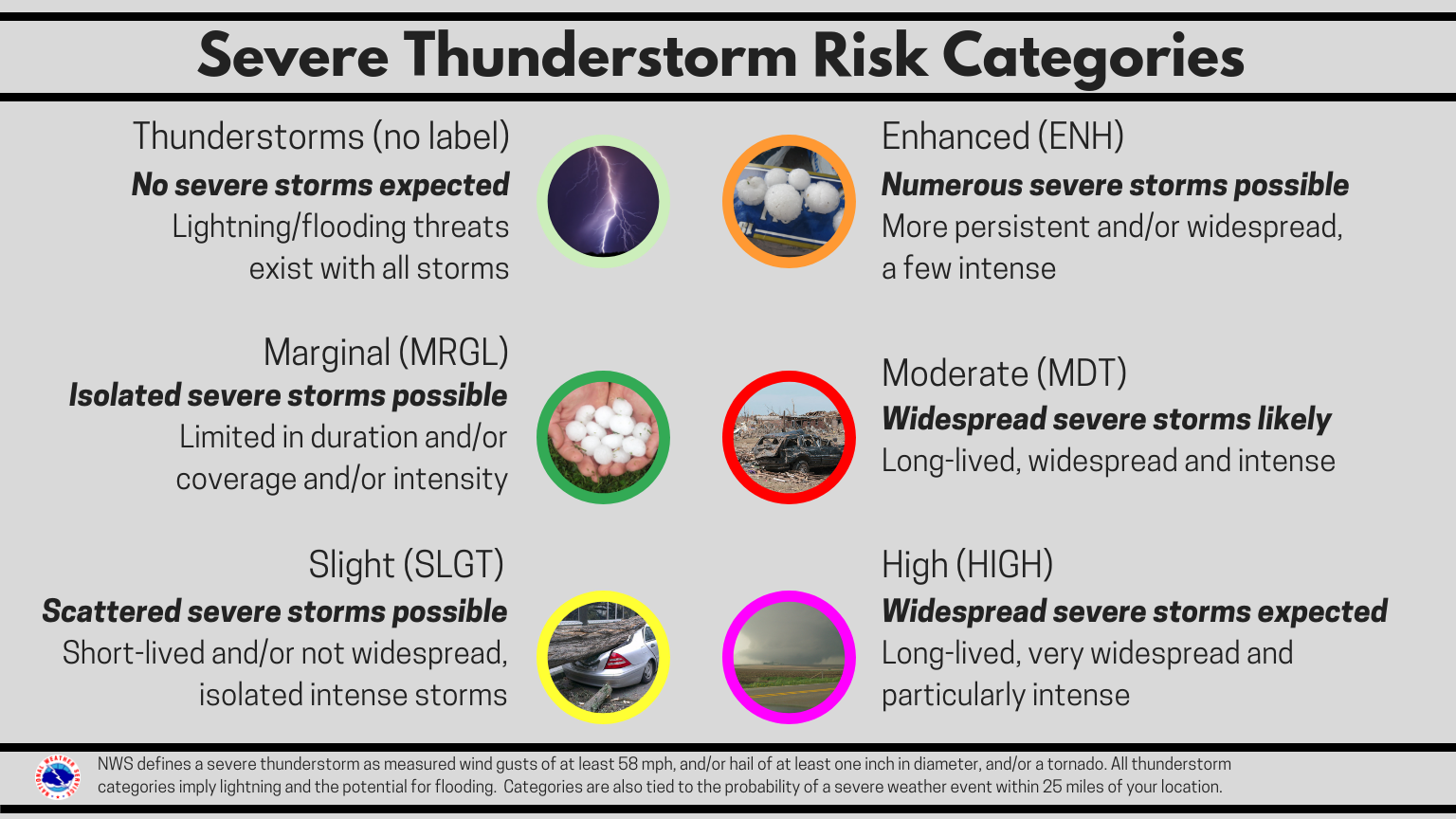
The Storm Prediction Center has half of the state in a severe storm risk on Saturday night until 7:00 am Sunday, with a Slight Risk from the AL/MS state line to as far east as Bear Creek (Marion Co.) to Coaling (Tuscaloosa Co.) to Orrville (Dallas Co.), and a Marginal Risk stretching as far east as Fairview (Cullman Co.) to Columbiana (Shelby Co.) to White Hall (Lowndes Co.)
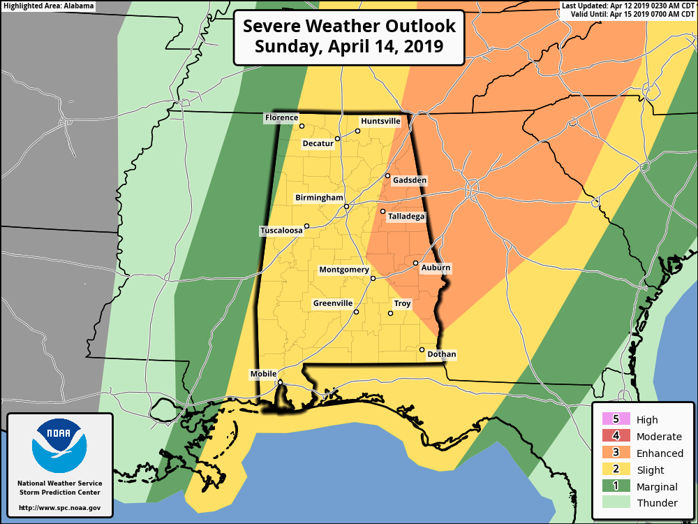
Then on Sunday from 7:00 am through the day, SPC has nearly all of Central Alabama in a Slight Risk with the exception of the eastern parts of the area. Locations east of a line from Gadsden (Etowah Co.) to Rockford (Coosa Co.) to Clayton (Barbour Co.).
Tornadoes and damaging winds up to 60 MPH will be the main threats with this severe weather event, with a much smaller threat of large hail up to one-inch in diameter (quarter-size).
Skies will be mainly cloudy throughout the day on Sunday with storms likely through the early afternoon hours, then we may have a few lingering showers during the rest of the afternoon and into the early evening hours before skies begin to clear out late. Highs will be in the lower 70s to the lower 80s with overnight lows dropping into the lower to mid-40s across the area from northwest to southeast.
If you do not have a weather emergency supply kit ready to go, now is the time to make one. Have a safety plan ready to act if your location goes under a warning, and talk it over with family members to make sure they know what to do. Never rely on sirens for your source of receiving warnings. Enable the WEAs (Wireless Emergency Alerts) on your cellphones and have an NOAA WeatherRadio for the home. Download the ABC 33/40 app on your mobile device so you can watch live tornado coverage from your safe place if you go under a warning.
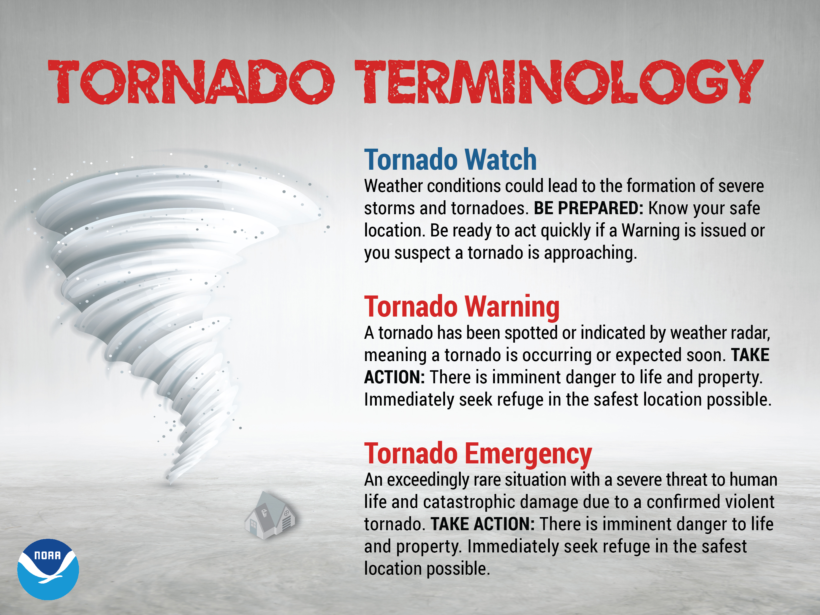
KNOW THE DIFFERENCE BETWEEN A TORNADO WATCH & A TORNADO WARNING
SEVERE THUNDERSTORM RISK CATEGORIES
Category: Alabama's Weather, ALL POSTS, Severe Weather
About the Author (Author Profile)
Scott Martin is an operational meteorologist, professional graphic artist, musician, husband, and father. Not only is Scott a member of the National Weather Association, but he is also the Central Alabama Chapter of the NWA president. Scott is also the co-founder of Racecast Weather, which provides forecasts for many racing series across the USA. He also supplies forecasts for the BassMaster Elite Series events including the BassMaster Classic.Subscribe
If you enjoyed this article, subscribe to receive more just like it.


