Severe Storms Possible Sunday
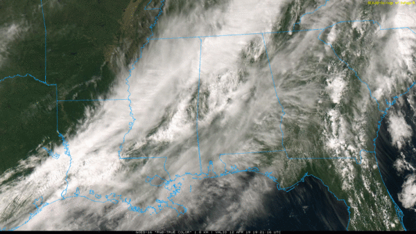
RADAR CHECK: A few scattered showers are over Central Alabama this afternoon, but most of the state is rain-free despite a mostly cloudy sky and a stalled front over the northwest counties. North of the front, temperatures are only in the low 60s in places like Hamilton and Haleyville, but to the south we are seeing mid to upper 70s.
Some rain is possible tonight, especially after midnight, as the front lifts northward as a warm front.
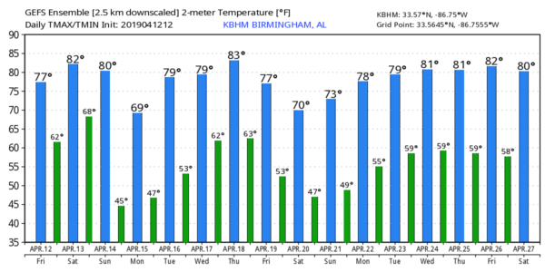
TOMORROW: The warm front will move into Tennessee, and most of Alabama should be dry tomorrow with just a few widely scattered showers. The sun will break out at times, and the high will be close to 80 degrees.
SEVERE WEATHER THREAT SUNDAY: A dynamic weather system will push a band of strong to severe thunderstorms into our state after midnight tomorrow night into Sunday morning. SPC has far West Alabama in an “enhanced risk” (level 3/5) of severe storms in their “Day 2” outlook which runs through 7:00 a.m. Sunday, and all of the state is in some type of risk on the “Day 3” outlook which is valid after 7:00 a.m. Sunday. An “enhanced risk” (level 3/5) is defined Sunday for the far eastern part of the state.
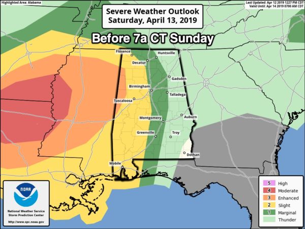
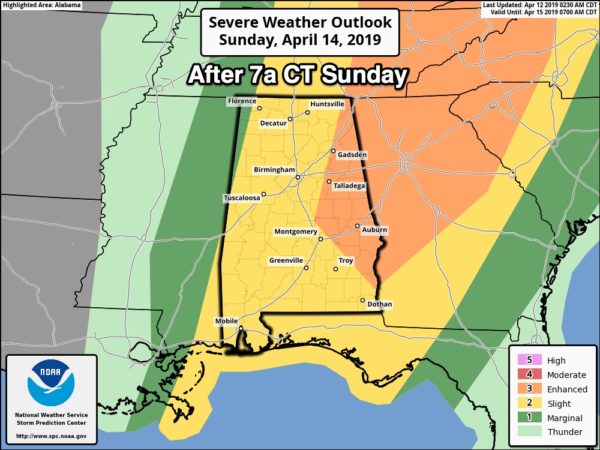
IMPORTANT: I am getting many questions concerning the inconsistencies in the severe weather graphics coming from the National Weather Service offices in Birmingham and Huntsville… And the Storm Prediction Center. I generally post severe weather outlooks from SPC… I don’t use graphics from NWS Birmingham because they leave out Cullman County, which is another confusing factor (Cullman County is in the Birmingham TV market, but served by the NWS in Huntsville. People in Cullman County should be watching Birmingham TV stations for weather coverage!!) Occasionally local NWS offices have a difference of opinion, and the outlooks conflict. I have good friends that work at SPC, and NWS Birmingham… They are excellent forecasters. I do hope that one day they will be able to coordinate their outlooks for consistency… But there is nothing I can do about it. Please do not get too caught up in risk categories, and map colors. Just understand all of Alabama has a severe weather threat after midnight tomorrow night into Sunday morning.
TIMING: The core severe weather threat will come from 3:00 a.m. until 12:00 noon Sunday. Another batch of thunderstorms will develop later in the day Sunday (3-7 p.m.)… and some of those storms could be strong across Northeast Alabama, but it remains to be seen if there will be enough instability and moisture for them to become severe.
THREATS: Storms could produce hail, damaging winds, and a few tornadoes. We note that new model guidance is showing a mass of thunderstorms along the Gulf Coast Sunday morning, and if that verifies it would help to reduce the severe weather threat over the northern two-thirds of the state. Let’s hope we just get away with some noisy storms Sunday morning with gusty winds and heavy rain… that is a real possibility. But, we still have to be prepared for severe storms since the Gulf Coast thunderstorm complex isn’t a lock.
RAIN: Rain amounts of 1 to 2 inches are expected; no major flooding issues are in the forecast.
CALL TO ACTION: Be sure you have a way of hearing warnings. Every Alabama home, business, and church must have a NOAA Weather Radio, properly programmed and with a battery backup. Be sure WEA (Wireless Emergency Alerts) are enabled on your phone. Know the safe place in your home, and have helmets, portable air horns, and hard sole shoes for everyone in the family there. If you live in a manufactured home and are put in a tornado warning polygon, you have to get out. Identify a shelter, or other safe structure that is available during the pre-dawn hours on Sunday morning. Every church should review their severe weather plan.
No need to be anxious about this; we are in the core of the spring tornado season, and having threats like this is common this time of the year. Just have a way of hearing warnings, and a good action plan.
FOOTBALL WEATHER: Both Auburn and Alabama play their spring football games tomorrow (1:00 kickoff in Tuscaloosa; 3:00 kickoff in Auburn). Just a small risk of a shower in Tuscaloosa, otherwise partly sunny and warm at both stadiums with temperatures around 80 degrees at kickoff.
NEXT WEEK: Monday and Tuesday will feature sunshine in full supply; lows will be in the 40s. The high Monday will be close to 70, and then in the 77-80 degree range Tuesday. Wednesday looks dry, then we will deal with another round of storms late Thursday and Thursday night. Those could be strong, possibly severe… but we need to get through Sunday’s storms before we can focus on that threat. See the Weather Xtreme video for maps, graphics, and more details.
ON THIS DATE IN 1945: A series of significant tornadoes raked Oklahoma, Arkansas, Missouri, and Illinois. Antlers, Oklahoma were nearly obliterated by a massive F5 tornado that zigzagged from southwest to northeast across the town. 69 people died in the twister. Another tornado killed eight people in Oklahoma City, Oklahoma. The disaster was overshadowed by the loss of President Franklin Roosevelt, who died suddenly at his vacation home at Warm Springs, Georgia.
BEACH FORECAST: Click here to see the AlabamaWx Beach Forecast Center page.
WEATHER BRAINS: Don’t forget you can listen to our weekly 90 minute show anytime on your favorite podcast app. This is the show all about weather featuring many familiar voices, including our meteorologists here at ABC 33/40.
CONNECT: You can find me on all of the major social networks…
Facebook
Twitter
Instagram
Pinterest
Snapchat: spannwx
I enjoyed seeing a big group at the School for Amazing Kids today in Pelham… be looking for them on the Pepsi KIDCAM today at 5:00 on ABC 33/40 News! My next Weather Xtreme video will be posted here by 7:00 a.m. Monday… keep an eye on the blog over the weekend for updates on the active weather we expect!
Category: Alabama's Weather, ALL POSTS, Weather Xtreme Videos
About the Author (Author Profile)
James Spann is one of the most recognized and trusted television meteorologists in the industry. He holds the AMS CCM designation and television seals from the AMS and NWA. He is a past winner of the Broadcast Meteorologist of the Year from both professional organizations.Subscribe
If you enjoyed this article, subscribe to receive more just like it.


