A Look At The Alabama Severe Weather Threat
A vigorous weather system will bring the potential for strong to severe thunderstorms across Alabama after midnight into tomorrow morning. While instability values are relatively modest, the dynamics involved will overcome that, most likely, with jet stream level winds of 120 knots, and 90 knots at 500 mb (18.000 feet off the ground). Strong to extreme low level shear will be in place.
SEVERE WEATHER OUTLOOK GRAPHICS: I am very hesitant to post any severe weather outlook map today. We normally use outlooks from NOAA’s Storm Prediction Center, the agency that issues severe weather watches and daily convective outlooks. Their meteorologists are top notch; people there like Rich Thompson, Roger Edwards, John Hart, Bryan Smith, etc are brilliant, and serve as role models for me and many other practitioners.
The National Weather Service in Birmingham also has extremely bright meteorologists, including their Science Operations Officer (SOO), Kevin Laws. Kevin is the best.
Sometimes they differ in opinion, and we have that situation today. I hesitate to post graphics from NWS Birmingham because they don’t include Cullman County, which isn’t in their CWA (County Warning Area). The problem is that Cullman County IS in the Birmingham TV market (people in Cullman County should watch BIRMINGHAM stations for weather coverage)… and I don’t like to post any severe weather outlook that doesn’t include them. It creates confusion.
SPC has an “enhanced risk” (level 3/5) for a part of West, and Northeast Alabama, defined in this composite map which includes their “Day 1” outlook (through 7am tomorrow), and the “Day 2” outlook (after 7am tomorrow). NWS Birmingham has the “enhanced risk” defined for all of Central Alabama.
BOTTOM LINE HERE: Forget worrying about if your town is in the yellow or orange. Understand ALL of Alabama will have a risk of severe storms after midnight tonight into tomorrow morning. Don’t get hung up in these risk areas or colors; no need to ask about any specific place. Do pay attention to the times.
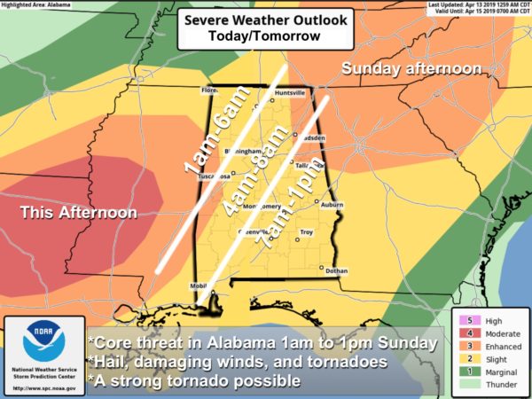
TIMING: Severe storms could be in West Alabama as early as 1:00 a.m…. they will move eastward through the morning hours, finally exiting into Georgia by 1:00 p.m. Additional showers or storms could form later in the day over North Alabama, but that is a conditional threat. There is some chance they could be strong to severe.
THREATS: Storms after midnight tonight into tomorrow morning could produce hail, damaging winds, and tornadoes. A few strong (EF-2 or higher) tornadoes are possible. There is still some chance a storm complex could develop near the Gulf Coast, interrupting inflow and reducing the severe weather threat over the rest of the state. But, the last few mesoscale model runs that backed off on that idea.
RAIN: Rain amounts of 1-2 inches are likely; for now we are not expecting any flooding issues.
CALL TO ACTION: People must have a way of hearing warnings, and that way should never, ever be a siren. Their purpose is only to reach a limited number of people outdoors. Every Alabama home and business must have a NOAA Weather radio, properly programmed and with a fresh battery backup. Be sure WEA (Wireless Emergency Alerts) are enabled on your phone (check notification settings)… even with no good weather app installed you will receive a tornado warning with a loud audible alert.
With this threat coming on Palm Sunday morning, every church needs a NOAA Weather Radio, and someone nearby that can hear the alarm if it sounds. And, of course, a plan on getting people out of the main worship sanctuary and into small hallways and bathrooms that offer better protection in the event a tornado warning is issued. The severe weather threat will be over in West Alabama by 6:00 a.m., but severe storms could be an issue during church hours for I-65 and points east.
If you live in a manufactured home, you have to GET OUT if a tornado warning is issued. Have a shelter identified, or other place identified that is open when you are at risk. Know how to get there quickly.
In your safe place, have helmets, portable air horns, and hard sole shoes for everyone.
THIS IS APRIL: We are in the core of the spring tornado season in Alabama. This type of threat happens often this time of the year, and is to be expected. No need to be anxious, just have a way of hearing warnings, and a plan.
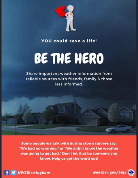
HELP US: Many people don’t read the blog, or pay attention to weather. Please let your family members, friends, and neighbors know about the threat. Inevitably, we will hear someone say tomorrow (we never knew this was supposed to happen). You can help us spread the word.
Keep an eye on the blog for forecast updates today and tonight!
Category: Alabama's Weather, ALL POSTS
About the Author (Author Profile)
James Spann is one of the most recognized and trusted television meteorologists in the industry. He holds the AMS CCM designation and television seals from the AMS and NWA. He is a past winner of the Broadcast Meteorologist of the Year from both professional organizations.Subscribe
If you enjoyed this article, subscribe to receive more just like it.


