The Severe Thunderstorm Warning For Northeastern Hale County Will Expire At 2:45 AM CDT
…THE SEVERE THUNDERSTORM WARNING FOR NORTHEASTERN HALE COUNTY WILL
EXPIRE AT 245 AM CDT…
The storms which prompted the warning have moved out of the area.
Therefore, the warning will be allowed to expire.
A Tornado Watch remains in effect until 300 AM CDT for central and
west central Alabama.
LAT…LON 3263 8753 3282 8767 3297 8742 3283 8742
3283 8747 3266 8747 3265 8753
TIME…MOT…LOC 0736Z 237DEG 36KT 3296 8740 3277 8732
A Severe Thunderstorm Warning Remains In Effect Until 2:45 AM CDT For Northeastern Hale County
Apr 14th @ 2:21 am

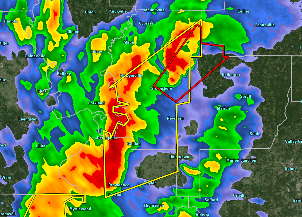
…A SEVERE THUNDERSTORM WARNING REMAINS IN EFFECT UNTIL 245 AM CDT FOR NORTHEASTERN HALE COUNTY… At 221 AM CDT, severe thunderstorms were located along a line extending from 9 miles southeast of Moundville to 6 miles east of Greensboro, moving northeast at 50 mph.
HAZARD…60 mph wind gusts.
SOURCE…Radar indicated.
IMPACT…Expect damage to roofs, siding, and trees. Locations impacted include… Greensboro and Wateroak.
A Severe Thunderstorm Warning Remains In Effect Until 2:45 AM CDT For Central Hale County
Apr 14th @ 2:09 am

…A SEVERE THUNDERSTORM WARNING REMAINS IN EFFECT UNTIL 245 AM CDT FOR CENTRAL HALE COUNTY… At 208 AM CDT, severe thunderstorms were located along a line extending from near Evansville to near Faunsdale, moving northeast at 50 mph.
HAZARD…60 mph wind gusts.
SOURCE…Radar indicated.
IMPACT…Expect damage to roofs, siding, and trees. Locations impacted include… Greensboro, Newbern, Sawyerville, Greensboro Municipal Airport, Wateroak, Cedarville and Laneville.
The Severe Thunderstorm Warning For Northeastern Marengo County Is Cancelled
Apr 14th @ 2:08 am

…THE SEVERE THUNDERSTORM WARNING FOR NORTHEASTERN MARENGO COUNTY IS CANCELLED…
The storms which prompted the warning have moved out of the warned area. Therefore, the warning has been cancelled. A Tornado Watch remains in effect until 300 AM CDT for central, southwestern and west central Alabama. LAT…LON 3297 8742 3283 8742 3283 8747 3266 8747 3265 8753 3249 8752 3248 8771 3276 8776 TIME…MOT…LOC 0708Z 228DEG 44KT 3281 8766 3249 8763
Severe Thunderstorm Warning Issued For Parts Of Hale And Marengo Counties Until 2:45AM
Apr 14th @ 1:55 am

The National Weather Service in Birmingham has issued a
* Severe Thunderstorm Warning for…
Northeastern Marengo County in southwestern Alabama…
Hale County in west central Alabama…
* Until 245 AM CDT.
* At 155 AM CDT, severe thunderstorms were located along a line extending from near Duffys Bend to Chickasaw State Park, moving northeast at 40 mph.
HAZARD…60 mph wind gusts.
SOURCE…Radar indicated.
IMPACT…Expect damage to roofs, siding, and trees.
* Locations impacted include…
Demopolis, Greensboro, Linden, Newbern, Faunsdale, Greensboro
Municipal Airport, Duffys Bend, Sawyerville, Arcola, Chickasaw
State Park, Old Spring Hill, Gallion, Wateroak, Cedarville and
Laneville.
Category: ALL POSTS
About the Author (Author Profile)
Subscribe
If you enjoyed this article, subscribe to receive more just like it.


