The Severe Thunderstorm Warning For East Central Jackson And Eastern Dekalb Counties Will Expire At 7:15 AM CDT
…THE SEVERE THUNDERSTORM WARNING FOR EAST CENTRAL JACKSON AND
EASTERN DEKALB COUNTIES WILL EXPIRE AT 715 AM CDT…
The storms which prompted the warning have weakened below severe
limits, and have exited the warned area. Therefore, the warning will
be allowed to expire.
A Tornado Watch remains in effect until 900 AM CDT for northeastern
Alabama.
To report severe weather, contact your nearest law enforcement
agency. They will relay your report to the National Weather Service
Huntsville Alabama.
A Severe Thunderstorm Warning Remains In Effect Until 7:15 AM CDT For East Central Jackson And Eastern Dekalb Counties
Apr 14th @ 6:50 am

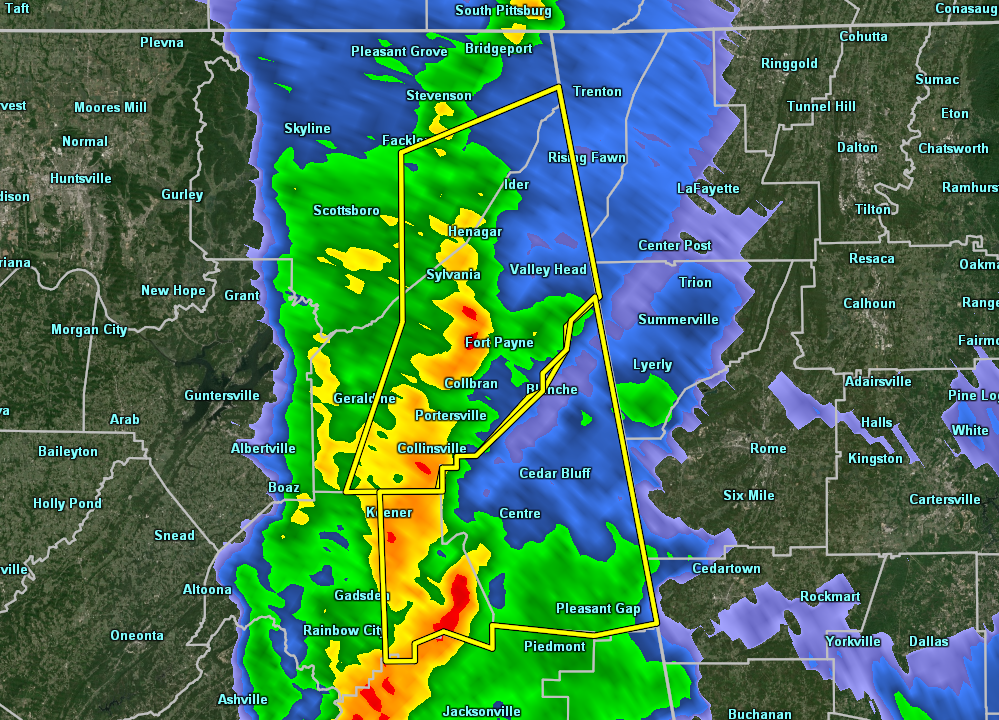
…A SEVERE THUNDERSTORM WARNING REMAINS IN EFFECT UNTIL 715 AM CDT FOR EAST CENTRAL JACKSON AND EASTERN DEKALB COUNTIES… At 650 AM CDT, severe thunderstorms were located along a line extending from near Ider to near Sylvania to near Sand Rock, moving east at 25 mph.
HAZARD…60 mph wind gusts.
SOURCE…Radar indicated.
IMPACT…Expect damage to roofs, siding, and trees. Locations impacted include… Fort Payne, Rainsville, Henagar, Sylvania, Ider, Valley Head, Hammondville, Mentone, Pine Ridge and Dog Town.
Severe Thunderstorm Warning Issued For Parts Of Dekalb And Jackson Counties Until 7:15AM
Apr 14th @ 6:37 am

The National Weather Service in Huntsville Alabama has issued a
* Severe Thunderstorm Warning for…
Southeastern Jackson County in northeastern Alabama…
DeKalb County in northeastern Alabama…
* Until 715 AM CDT.
* At 636 AM CDT, severe thunderstorms were located along a line extending from near Pisgah to near Rainsville to near Tabor Road, moving east at 25 mph.
HAZARD…60 mph wind gusts.
SOURCE…Radar indicated.
IMPACT…Expect damage to roofs, siding, and trees.
* Locations impacted include…
Fort Payne, Rainsville, Henagar, Crossville, Sylvania, Fyffe, Powell, Ider, Pisgah and Valley Head.
Category: ALL POSTS
About the Author (Author Profile)
Subscribe
If you enjoyed this article, subscribe to receive more just like it.


