Storms Return Late Thursday/Thursday Night
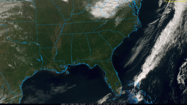
SEVERE CLEAR: Nothing but sunshine across Alabama this afternoon; temperatures are generally in the 65-70 degree range. Tonight will be fair and cool with a low in the upper 40s for most communities.
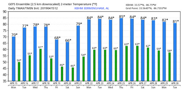
Tomorrow and Wednesday will be warmer; we expect a good supply of sunshine both days with a high close to 80 tomorrow, followed by low 80s Wednesday. During the day Wednesday into Wednesday night severe storms will likely break out in areas well west of Alabama, from Texas to the Great Lakes, as another vigorous weather system moves out of the western U.S.
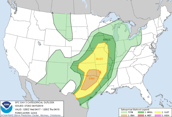
SEVERE WEATHER THREAT LATE THURSDAY/THURSDAY NIGHT: South winds will increase during the day Thursday as the system to the west approaches, and a band of showers and storms will push into Alabama late in the day. The new global model guidance (12Z) is slower, suggesting the main window for stronger storms in our state will come from 3:00 p.m. Thursday until 3:00 a.m. Friday. SPC has all of Alabama in a severe weather risk for late Thursday and Thursday night.
Thunderstorms during the time frame could produce large hail, damaging winds, and a few tornadoes. Still too early to really define the magnitude of the event, and the placement of the highest risks. This is April in Alabama, and having events like this area common this time of the year; the core of our spring tornado season.
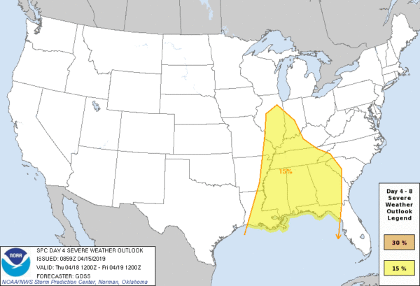
FRIDAY: The severe weather threat shifts east of Alabama Friday; around here the day will be cloudy and much cooler as a deep upper low moves right over the state. We will have the risk of some rain at times; we might even see some small hail from light rain showers due to the very cold air aloft associated with the upper low. Temperatures could very well hold in the 50s all day across the northern half of the state.
EASTER WEEKEND: The weekend will be brighter and warmer. We are forecasting a good supply of sunshine Saturday and Sunday with a warming trend; the high Saturday will be near 70, and in the upper 70s Sunday.
NEXT WEEK: The first half of the week will be dry; new guidance hints at some chance of showers and storms by Thursday or Friday. Afternoon highs will exceed 80 degrees on most days… See the Weather Xtreme video for maps, graphics, and more details.
ON THIS DATE IN 2011: The “forgotten” tornado outbreak of April 15, 2011. Throughout the day, 45 tornado warnings and 19 severe thunderstorm warnings were issued for Central Alabama. Out of the 29 confirmed tornadoes, the total damage path length was over 244 miles, with 10 of those tornadoes having damage paths over 10 miles long. Four people were killed, including three at Boones Chapel in northern Autauga County (they were in a mobile home).
The event was “forgotten” by many due to what would happen 12 days later, on April 27, 2011, when a generational tornado outbreak would kill 252 people in our state.
BEACH FORECAST: Click here to see the AlabamaWx Beach Forecast Center page.
WEATHER BRAINS: Don’t forget you can listen to our weekly 90 minute show anytime on your favorite podcast app. This is the show all about weather featuring many familiar voices, including our meteorologists here at ABC 33/40.
CONNECT: You can find me on all of the major social networks…
Facebook
Twitter
Instagram
Pinterest
Snapchat: spannwx
I enjoyed seeing the entire student body of Southview Elementary in Tuscaloosa, and the third graders at Greystone Elementary in Hoover today… be looking for them on the Pepsi KIDCAM today at 5:00 and 6:00 on ABC 33/40 News! The next Weather Xtreme video will be posted here by 7:00 a.m. tomorrow…
Category: Alabama's Weather, ALL POSTS, Weather Xtreme Videos
About the Author (Author Profile)
James Spann is one of the most recognized and trusted television meteorologists in the industry. He holds the AMS CCM designation and television seals from the AMS and NWA. He is a past winner of the Broadcast Meteorologist of the Year from both professional organizations.Subscribe
If you enjoyed this article, subscribe to receive more just like it.


