Showers/Storms Return Later Today
RAIN RETURNS: Showers and thunderstorms will return to Alabama today and tonight as the next upper air wave to the west approaches. At daybreak, a band of severe storms is moving through western Mississippi; those should weaken as they move east of I-55. That decaying band of showers will enter West Alabama later this morning.
Then, this afternoon, a new batch of thunderstorms will develop closer to the Gulf Coast, and those could be severe. SPC has defined a “slight risk” (level 2/5) for areas south of a line from Sweetwater to Chapman to Geneva, and a “marginal risk” (level 1/5) as far north as Tuscaloosa, Prattville, and Eufaula.
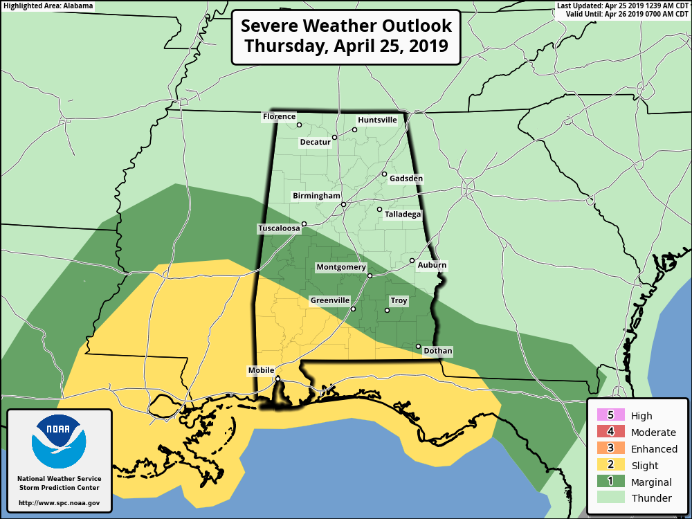
Storms this afternoon and early tonight over South Alabama could produce strong, possibly damaging winds, and some hail. The tornado risk is low, but not zero. For now severe thunderstorms are not expected over the northern half of the state.
Rain amounts across North/Central Alabama should be around 1/2 inch, with heavier totals down to the south. Showers and thunderstorms will end after midnight as they move into Georgia.
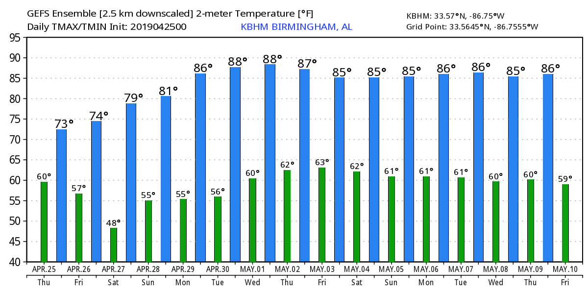
TOMORROW AND THE WEEKEND: The weather will be dry with warm afternoons and pleasant nights. Lots of sunshine tomorrow and Saturday; the high tomorrow will be in the mid 70s, and close to 80 Saturday. For Sunday, we expect a partly sunny sky with a high in the 77-80 degree range. Perfect weather for race weekend at Talladega.
NEXT WEEK: An upper ridge will build across the Deep South, setting up a mostly dry and very warm week. Highs will be in the mid 80s most days, and some places could see upper 80s along the way. We could see a few showers late in the week on Friday with a weak front approaching from the north… See the Weather Xtreme video for maps, graphics, and more details.
ON THIS DATE IN 2011: The great tornado outbreak of April 2011 was underway. An intense supercell thunderstorm tracked near the Little Rock area and a tornado emergency was declared for the city of Vilonia. A large EF-2 wedge tornado struck the town, subsequently causing severe damage and killing four people. A strong EF-3 tornado had also struck the Hot Springs Village area earlier that evening; that tornado caused severe damage and resulted in one death. Later that evening, another EF-2 tornado caused extensive damage to both a school building and Little Rock Air Force Base as well. A total of 42 tornadoes and four tornado-related deaths were confirmed on the April 25, 2011.
BEACH FORECAST: Click here to see the AlabamaWx Beach Forecast Center page.
WEATHER BRAINS: Don’t forget you can listen to our weekly 90 minute show anytime on your favorite podcast app. This is the show all about weather featuring many familiar voices, including our meteorologists here at ABC 33/40.
CONNECT: You can find me on all of the major social networks…
Facebook
Twitter
Instagram
Pinterest
Snapchat: spannwx
I have weather programs today at Gresham Elementary, and Helena Intermediate School… look for the next Weather Xtreme video here by 4:00 this afternoon… enjoy the day!
Category: Alabama's Weather, ALL POSTS, Weather Xtreme Videos
About the Author (Author Profile)
James Spann is one of the most recognized and trusted television meteorologists in the industry. He holds the AMS CCM designation and television seals from the AMS and NWA. He is a past winner of the Broadcast Meteorologist of the Year from both professional organizations.Subscribe
If you enjoyed this article, subscribe to receive more just like it.


