Severe Thunderstorm Watch Likely Within The Next Hour Or Two
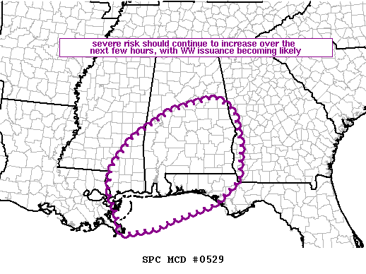
Latest Mesoscale Update from the Storm Prediction Center has the likely possibility of a watch being issued for the southern half of Central Alabama and down into the southern portions of the state, the western parts of the Florida Panhandle, and extreme southwestern Mississippi. More than likely, it will be a severe thunderstorm watch, but I’m waiting on final word from NWS Birmingham and the SPC.
The main threat continues to be from damaging winds up to 60 MPH, but there is avery low threat of an isolated tornado or two as some backing of the low-level flow has been seen over southern portions of the state near the Gulf coast.
As soon as the watch is issued, we’ll have a post up on the blog. Stay tuned.
Category: Alabama's Weather, ALL POSTS, Severe Weather
About the Author (Author Profile)
Scott Martin is an operational meteorologist, professional graphic artist, musician, husband, and father. Not only is Scott a member of the National Weather Association, but he is also the Central Alabama Chapter of the NWA president. Scott is also the co-founder of Racecast Weather, which provides forecasts for many racing series across the USA. He also supplies forecasts for the BassMaster Elite Series events including the BassMaster Classic.Subscribe
If you enjoyed this article, subscribe to receive more just like it.


