

Potential For Stronger To Severe Storms Continue; Scattered Storms Developing

At 1:05 pm, we have now entered into the window of when we can expect stronger to severe thunderstorms across Central Alabama. With the breaks in the cloud cover and heating, we’ll have to watch for any thunderstorm development across the area ahead of the main disorganized line of storms that will move in later this afternoon. We already have several scattered thunderstorms out there across the area, especially ones over St. Clair, Talladega, and Calhoun counties, back to the west over Tuscaloosa and Pickens counties, and down to the south over Perry, Marengo, and Dallas counties. All of these are moving off to the northeast at roughly 35 MPH.
The main action at this point continues to be back over Mississippi and back over the eastern parts of Arkansas and Louisiana. We will see that action begin to move into Central Alabama later in the afternoon and into the early evening hours.
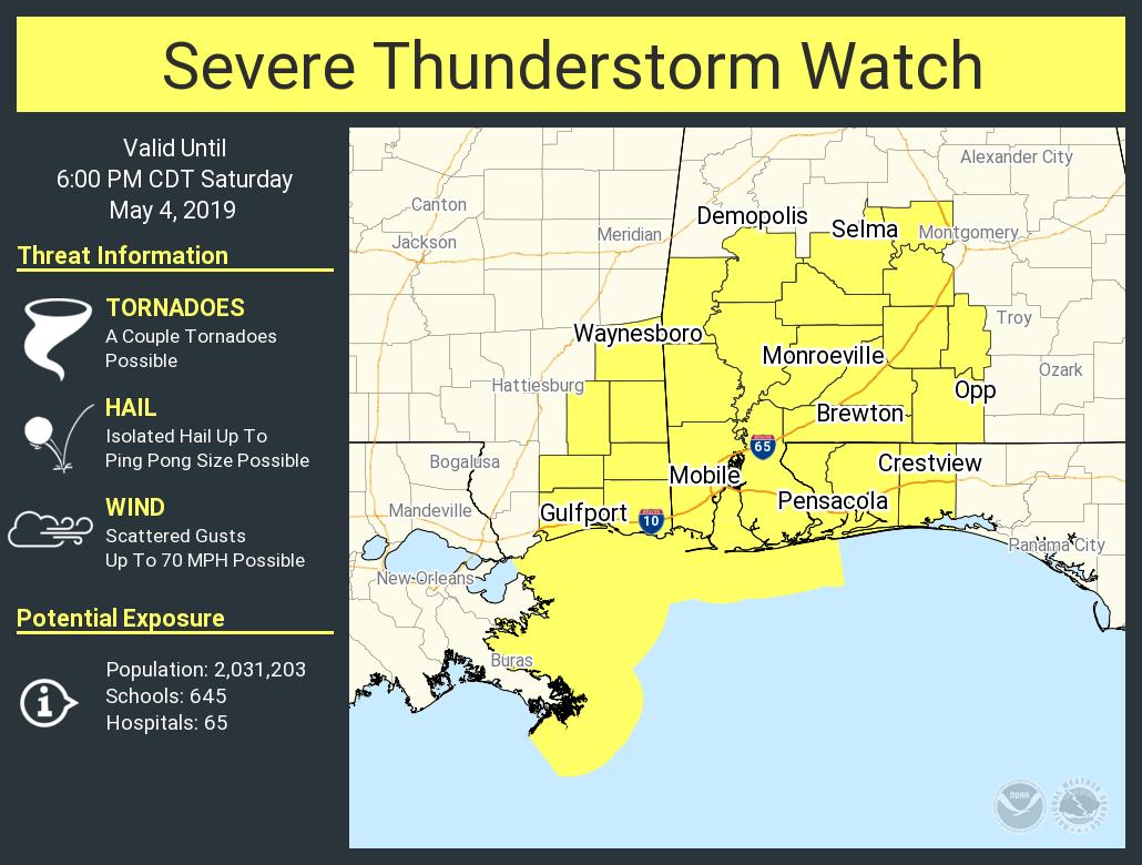
A Severe Thunderstorm Watch continues until 6:00 pm this evening for Autauga, Dallas, Lowndes, and Marengo counties in the southwestern parts of Central Alabama. Threats that are possible within the watch locations include damaging winds up to 70 MPH, isolated hail up to ping pong ball size, and an isolated tornado or two.
Forecast continues to stay on track… the earlier activity seems to have made an impact in the thinking for the northern portions of Central Alabama as NWS Birmingham has removed locations north of a line from Reform to Gardendale to Piedmont out of any severe storm risk. They have a Marginal Risk for locations south of that line down to a line from Demopolis to Clanton to Alexander City and a Slight Risk for locations south of that through the remainder of the Central Alabama counties. We’ll have to see if the break in the clouds will make the air north of that line more unstable and the risk will have to be moved back northward.
The main window for stronger to severe storms remain the same, from now until 10:00 pm. Locations along and west of a line from Brookwood to Uniontown could see those storms between 1:00 pm and 5:00 pm. Locations east of that to a line from Ohatchee to Rockford to Montgomery could see those storms between 3:00 pm and 7:00 pm. Locations east of that could see strong to severe storms from 6:00 pm to 10:00 pm.
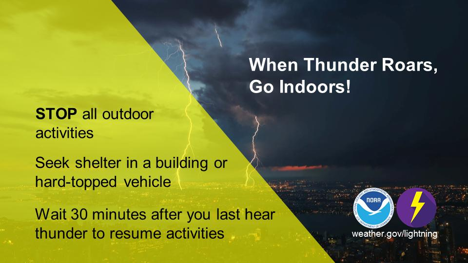
If you have an outdoor event today, stay weather aware, and be sure that you have an indoor place to go if a thunderstorm approaches and moves over your location. Lightning can strike many miles away from the parent thunderstorm. If you can hear thunder, you are close enough to the parent storm to be struck by lightning.
Be prepared and have your kits and safe place ready just in case you go under a warning. Treat a severe thunderstorm warning as a tornado warning. Deaths and injuries can occur in severe thunderstorms. We’ll continue to have updates throughout the day and into the night. Stay tuned and stay weather aware.
Category: Alabama's Weather, ALL POSTS, Severe Weather
About the Author (Author Profile)
Scott Martin is an operational meteorologist, professional graphic artist, musician, husband, and father. Not only is Scott a member of the National Weather Association, but he is also the Central Alabama Chapter of the NWA president. Scott is also the co-founder of Racecast Weather, which provides forecasts for many racing series across the USA. He also supplies forecasts for the BassMaster Elite Series events including the BassMaster Classic.Subscribe
If you enjoyed this article, subscribe to receive more just like it.


