Severe Thunderstorm Warning for Parts of Blount County Until 1:30 p.m.
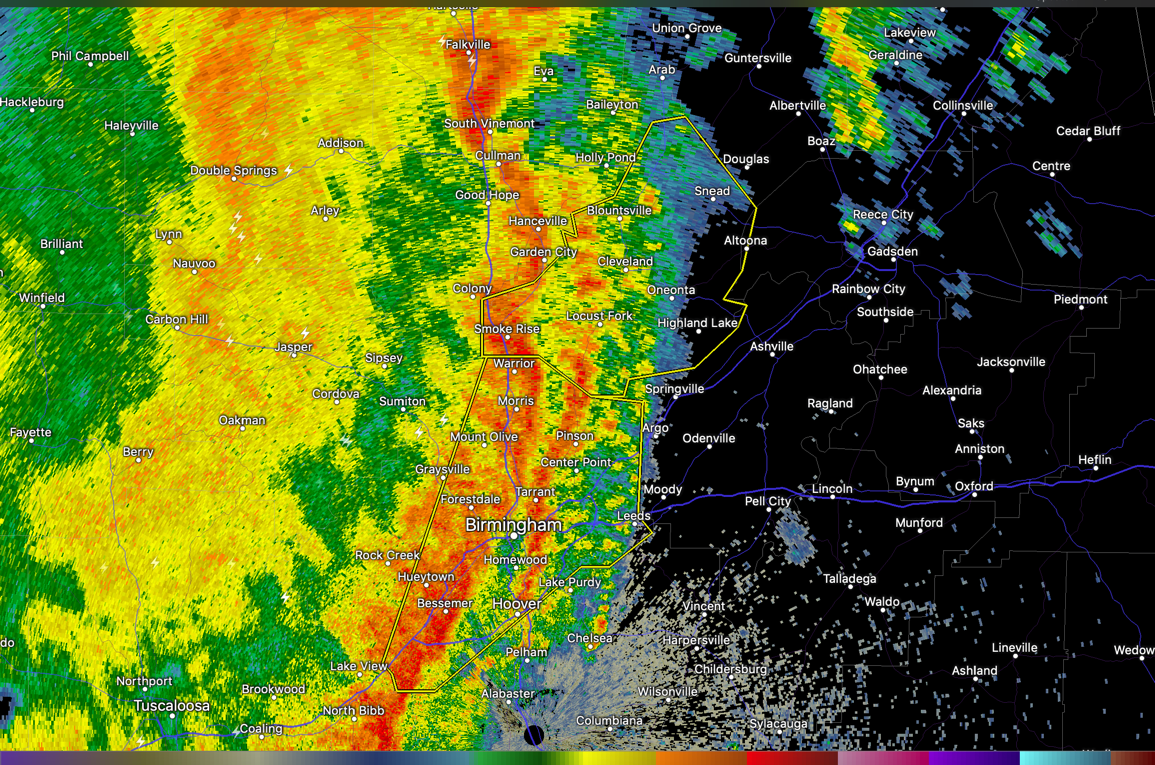
THE NATIONAL WEATHER SERVICE IN BIRMINGHAM HAS ISSUED A
* SEVERE THUNDERSTORM WARNING FOR…
BLOUNT COUNTY IN CENTRAL ALABAMA…
* UNTIL 130 PM CDT.
* AT 1224 PM CDT, SEVERE THUNDERSTORMS WERE LOCATED ALONG A LINE
EXTENDING FROM NEAR GOOD HOPE TO MORRIS, MOVING EAST AT 35 MPH.
HAZARD…60 MPH WIND GUSTS.
SOURCE…RADAR INDICATED.
IMPACT…EXPECT DAMAGE TO ROOFS, SIDING, AND TREES.
* LOCATIONS IMPACTED INCLUDE…
ONEONTA, BLOUNTSVILLE, CLEVELAND, DALLAS, LOCUST FORK, ALTOONA,
SNEAD, SUSAN MOORE, WALNUT GROVE, TRAFFORD, ALLGOOD, FAIRVIEW,
HAYDEN, NECTAR, ROSA, COUNTY LINE, MCLARTY, BANGOR, STRAWBERRY AND
BLOUNT SPRINGS.
PRECAUTIONARY/PREPAREDNESS ACTIONS…
FOR YOUR PROTECTION MOVE TO AN INTERIOR ROOM ON THE LOWEST FLOOR OF A
BUILDING.
HAIL…<.75IN WIND...60MPH
Category: ALL POSTS
About the Author (Author Profile)
Bill Murray is the President of The Weather Factory. He is the site's official weather historian and a weekend forecaster. He also anchors the site's severe weather coverage. Bill Murray is the proud holder of National Weather Association Digital Seal #0001 @wxhistorianSubscribe
If you enjoyed this article, subscribe to receive more just like it.


