Hot, Mostly Dry Weather Persists
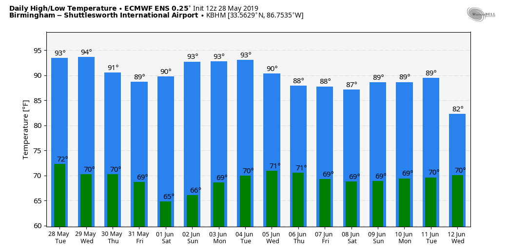
NOT MUCH CHANGE THROUGH THE WEEKEND: A very persistent upper air pattern, involving a strong upper high across the Southeast U.S… will persist through the weekend… meaning little day to day change in our weather. Mostly sunny, hot days and fair nights will continue through Sunday.
A few isolated afternoon showers or storms could pop up tomorrow over the southern counties of the state, and any showers over the weekend will be few and far between. Highs will be in the 92-95 degree range today, but heat levels back down a bit tomorrow through Sunday with maximum temperatures in the 88-92 degree range.
The upper high will deflect the major rain producing systems west and north of Alabama; there is a risk of severe storms again today in a broad zone from Texas to the upper Atlantic coast. Some of the cities in “enhanced risk” areas include Dallas, Little Rock, St. Louis, Baltimore, and Philadelphia.
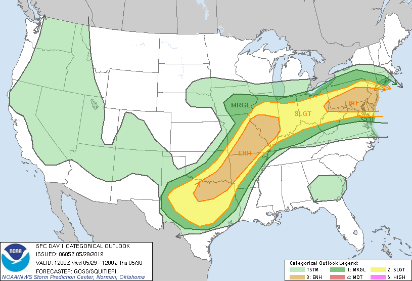
But, the good news is that the severe weather pattern will relax for these areas later this week, and no severe storms are forecast anywhere in the nation by Friday.
NEXT WEEK: Hot and mostly dry weather will continue Monday through Wednesday with afternoon highs not too far from 90 degrees. But, the upper ridge weakens and we will bring in the chance of scattered showers and thunderstorms Thursday and Friday with highs in the upper 80s. See the Weather Xtreme video for maps, graphics, and more details.
TORNADO YESTERDAY SOUTHWEST OF KANSAS CITY: Survey teams will be out this morning reviewing tornado damage near Lawrence Kansas; some estimated the tornado to be a mile wide during the event yesterday. Injuries were reported, but there were no fatalities. Thankfully the tornado dissipated just before getting into Kansas City as the parent storm moved northeast.
ON THIS DATE IN 1982: Two significant tornadoes ripped through southern Illinois. The most severe was an F4 that touched down northeast of Carbondale, Illinois then moved to Marion. The twister had multiple vortices within the main funnel. Extensive damage occurred at the Marion Airport. A total of 10 people were killed, and 181 were injured. 648 homes and 200 cars were damaged or destroyed, with total damages around $100 million.
BEACH FORECAST: Click here to see the AlabamaWx Beach Forecast Center page.
WEATHER BRAINS: Don’t forget you can listen to our weekly 90 minute show anytime on your favorite podcast app. This is the show all about weather featuring many familiar voices, including our meteorologists here at ABC 33/40.
CONNECT: You can find me on all of the major social networks…
Facebook
Twitter
Instagram
Pinterest
Snapchat: spannwx
Look for the next Weather Xtreme video here by 4:00 this afternoon… enjoy the day!
Category: Alabama's Weather, ALL POSTS, Weather Xtreme Videos
About the Author (Author Profile)
James Spann is one of the most recognized and trusted television meteorologists in the industry. He holds the AMS CCM designation and television seals from the AMS and NWA. He is a past winner of the Broadcast Meteorologist of the Year from both professional organizations.Subscribe
If you enjoyed this article, subscribe to receive more just like it.


