Occasional Rain Through Monday
WET PATTERN CONTINUES: A deep layer of tropical moisture will persist over Alabama through the weekend, meaning a continued wet pattern with occasional showers and thunderstorms daily. SPC has the southern two-thirds of the state in a “marginal risk” (level 1/5) of severe storms for today…
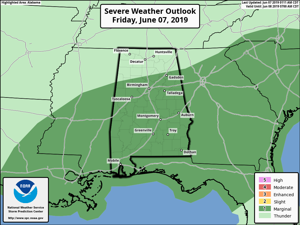
A very moist and moderately unstable airmass will reside across the state as an upper trough to the west slowly shifts eastward. Pockets of greater instability and lapse rates will coincide with modest shear, which could lead to a few strong wind gusts in better organized convection. We also note a flash flood watch remains in effect today and tonight for southern parts of Mobile and Baldwin counties, and the western part of the Florida Panhandle.
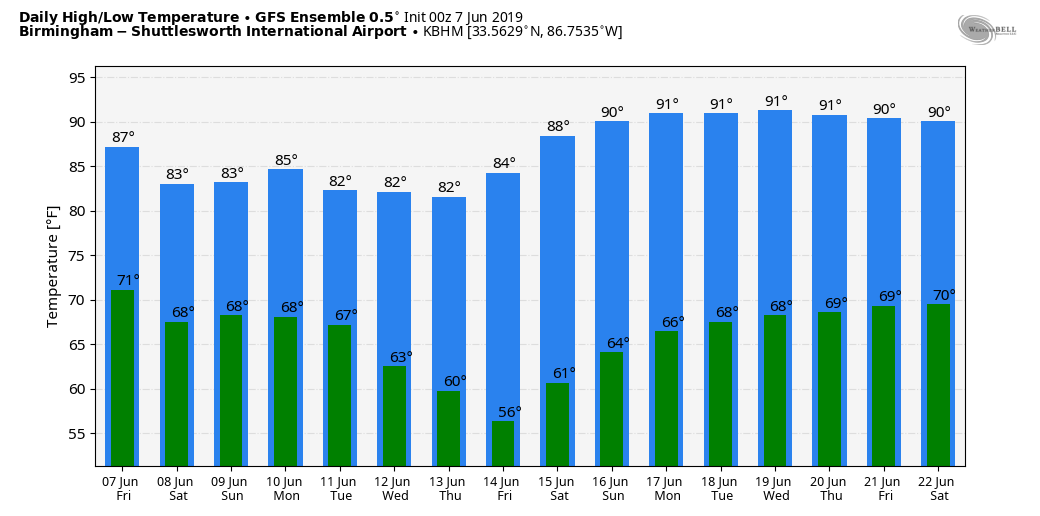
The high today will be in the 80-85 degree range.
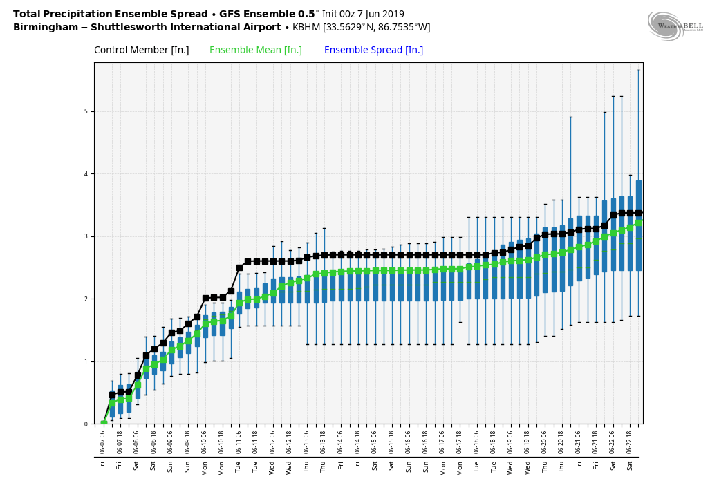
No real change for the weekend; we will deal with periods of rain and a few thunderstorms tomorrow and Sunday with highs in the low to mid 80s. There will be some decent breaks in the rain, and the sun might peek out at times. No organized storms are expected. Additional rain amounts of 2-4 inches are likely today through Sunday night for most of the state.
NEXT WEEK: We will continue to forecast a good chance of rain at times Monday, but the weather trends drier Tuesday and Wednesday. Still, global model data suggests we will need hang on to a chance of showers over East Alabama on these two days. Thursday and Friday look generally dry. Highs through the week will be mostly in the mid 80s. See the Weather Xtreme video for maps, graphics, and more details.
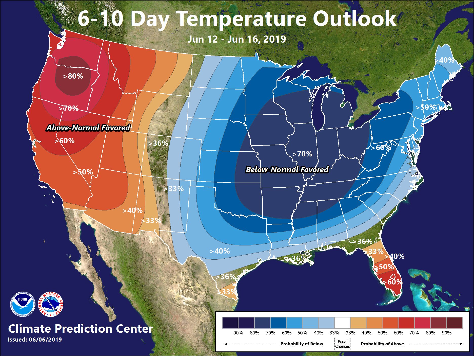
On the latest 6-10 day outlook from CPC (the Climate Prediction Center), for the period June 12-16), temperatures are expected to be below average over the central and eastern part of the nation.
RAIN SO FAR: Some of the heavier storm totals have come in from West Alabama; our Skywatcher at Coker (just west of Tuscaloosa), Ronald Hughes, reports 4.26″. Bud Bean in Northport has measured 2.70″.
ON THIS DATE IN 1816: The following is found on page 31, from the book, “History of the American Clock Business for the Past Sixty Year, and Life of Chauncey Jerome,” written by Chauncey Jerome. The book was published in 1860. “The next summer was a cold one of 1816, which none of the old people will ever forget, and which many of the young have heard a great deal about. There was ice and snow in every month of the year. I well remember on the seventh of June, while on my way to work, about a mile from home, dressed throughout with thick woolen clothes and an overcoat on, my hands got so cold that I was obliged to lay down my tools and put on a pair of mittens which I had in my pocket. It snowed about an hour that day.” This bitter cold event occurred in Plymouth, Connecticut.
Evidence suggests that the anomaly was predominantly a volcanic winter event caused by the massive 1815 eruption of Mount Tambora in the Dutch East Indies (now Indonesia). This eruption was the largest eruption in at least 1,300 years, and perhaps exacerbated by the 1814 eruption of Mayon in the Philippines.
BEACH FORECAST: Click here to see the AlabamaWx Beach Forecast Center page.
WEATHER BRAINS: Don’t forget you can listen to our weekly 90 minute show anytime on your favorite podcast app. This is the show all about weather featuring many familiar voices, including our meteorologists here at ABC 33/40.
CONNECT: You can find me on all of the major social networks…
Facebook
Twitter
Instagram
Pinterest
Snapchat: spannwx
Look for the next Weather Xtreme video here by 4:00 this afternoon… enjoy the day!
Category: Alabama's Weather, ALL POSTS, Weather Xtreme Videos
About the Author (Author Profile)
James Spann is one of the most recognized and trusted television meteorologists in the industry. He holds the AMS CCM designation and television seals from the AMS and NWA. He is a past winner of the Broadcast Meteorologist of the Year from both professional organizations.Subscribe
If you enjoyed this article, subscribe to receive more just like it.


