Lower Humidity, Cooler Nights Ahead
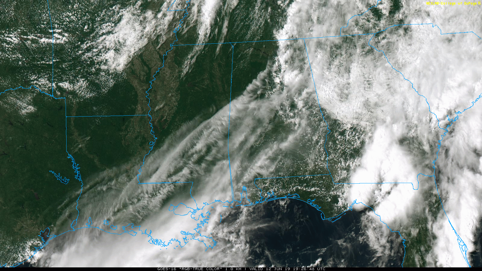
RADAR CHECK: As forecast, we have strong thunderstorms over the eastern half of Alabama this afternoon. They are all east of I-65, and some of the heavier storms are producing gusty winds and small hail. Otherwise, we have a mix of sun and clouds across the state with afternoon temperatures in the 80s away from the showers. Showers and storms will end this evening, and the sky will be mostly clear late tonight.
TOMORROW/FRIDAY: Some amazingly comfortable weather is likely for all of Alabama tomorrow and Friday as very dry air drops into the state. Look for sunny pleasant days, lower humidity levels, and cooler nights. The high tomorrow will be between 80 and 83, and in the 82-85 degree range Friday. We drop into the 50s Friday morning, and some of the normally colder spots across North Alabama might touch the upper 40s.
THE ALABAMA WEEKEND: Saturday will be mostly sunny and warmer with a high in the upper 80s… then we will bring in the chance of scattered, mostly afternoon and evening showers and thunderstorms Sunday as moisture levels begin to rise. Chance of any one spot getting wet Sunday is about one in three, and the high will be in the mid to upper 80s.
NEXT WEEK: For now we are expecting very routine early summer weather here in Alabama… partly sunny days with the risk of a few scattered showers and storms each day during the peak of the daytime heating process. Highs will be between 87 and 90 degrees most days… See the Weather Xtreme video for maps, graphics, and more details.
TROPICS: All is quiet across the Atlantic basin, and tropical storm formation is not expected over the next 7 days.
ON THIS DATE IN 2005: The remnant circulation of Tropical Storm Arlene moved through North/Central Alabama… Arlene’s local effects were rather minor. Storm total rainfall generally was 1 to 3 inches east of Interstate 65, and 2 to 5 inches west of Interstate 65, with isolated higher amounts. Estimated maximum wind gusts were 30 to 40 mph, with a few isolated higher amounts. The heaviest rain and the strongest winds were generally experienced along and west of Interstate 65. Several trees and power lines were blown down across Central Alabama with a few power outages. Minor local flooding and river flooding occurred.
BEACH FORECAST: Click here to see the AlabamaWx Beach Forecast Center page.
WEATHER BRAINS: Don’t forget you can listen to our weekly 90 minute show anytime on your favorite podcast app. This is the show all about weather featuring many familiar voices, including our meteorologists here at ABC 33/40.
CONNECT: You can find me on all of the major social networks…
Facebook
Twitter
Instagram
Pinterest
Snapchat: spannwx
Look for the next Weather Xtreme video here by 7:00 a.m. tomorrow…
Category: Alabama's Weather, ALL POSTS, Weather Xtreme Videos
About the Author (Author Profile)
James Spann is one of the most recognized and trusted television meteorologists in the industry. He holds the AMS CCM designation and television seals from the AMS and NWA. He is a past winner of the Broadcast Meteorologist of the Year from both professional organizations.Subscribe
If you enjoyed this article, subscribe to receive more just like it.


