Weather Xtreme Video: A Hot Father’s Day, But Shower/Storm Chances Increase This Week
Happy Father’s Day to all the dads out there! Thanks for all you do, Dad!
WE NEED RAIN, AND WE ARE GOING TO GET SOME: The pattern is beginning to change across Alabama and the southern United States. High pressure is centered off the North Carolina Outer Banks this morning. As that anticyclone has slid to the east, our winds have shifted to southerly. As a result, heat and humidity levels have risen. A trough of low pressure in the upper atmosphere will be pushing eastward this week, keeping Alabama in a southwesterly flow. Disturbances in the flow will enhance our shower and thunderstorm chances at times. Timing those disturbances will be difficult, but we will do our best to give you some idea of what to expect.
STRAWBERRY MOON MONDAY: Before we get started, look for a beautiful full moon rising in the east this evening. It will technically already be waning, as the instant of fullness occurs at 3:31 a.m. CDT Monday, but it will appear full still Monday evening. In fact, it will appear full this evening as well. It is called a “Strawberry Moon” because this is when every Algonquin tribe harvested strawberries. Tonight, the nearly full moon will be paired with a very bright Jupiter in the southeast sky. Hopefully, skies will be clear enough for us to enjoy it.
PINNING DOWN RAIN TIMING: This will be a difficult prospect as we will be dealing with disturbances in a southwesterly upper flow across Alabama and the Southeast. We probably get through much of today and Monday without very much, but by Monday night, showers and storms should become more common across the area. Look for occasional rounds of showers and storms through the end of the week, thinning out for the weekend. With the expected increase in clouds and showers, we should be able to hold daily highs in the middle and upper 80s, which is very close to normal for this time of year in Alabama.
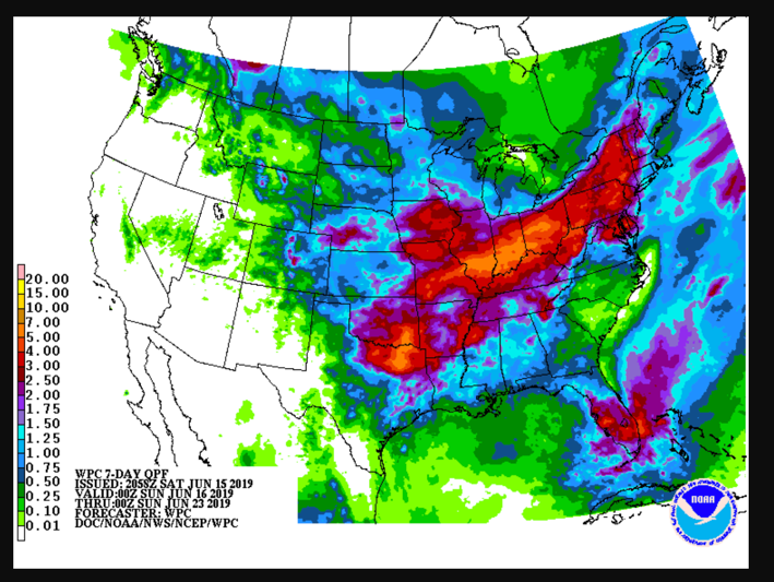
TOTAL RAINFALL AMOUNTS: The scattered nature of the precipitation will keep rainfall amounts from getting out of hand, and when it is all said and done, most spots will average between an inch and 1.25 inches of rain by next Sunday. Hopefully enough to keep the recent drought conditions at bay for most locations, but not a chance to get ahead of it either. Here are rainfall amounts from the Weather Prediction Center over the next seven days.
GULF COAST WEATHER: Fairly typical beach weather through Tuesday along the beautiful beaches of Alabama and Northwest Florida. 8 or so hours of sunshine, widely scattered mainly afternoon and evening thunderstorms, highs near 90F and lows in the middle 70s. Rain and storms will increase starting Wednesday and lasting into Friday. Things will return to fairly typical summerlike conditions by the weekend. Water temperatures are running around 83F.
Click here to see the Beach Forecast Center page.
WEATHERBRAINS: This week, the panel is talking to Bryan Busby, the Chief Meteorologist from KMBC in Kansas City. Check out the weekly netcast that’s all about the weather at www.WeatherBrains.com. You can also subscribe on iTunes. You can watch the show live at live.bigbrainsmedia.com You will be able to see the show on the James Spann 24×7 weather channel on cable or directly over the air on the dot 2 feed.
ON THIS DATE IN 1972: Agnes was born on this date, forming as a tropical storm east of the Yucatan Peninsula. Agnes would be a storm with two distinct lives. She would move north over the Gulf of Mexico and strike the Florida Panhandle as a minimal hurricane. A few days later, the remnants of Hurricane Agnes would be rejuvenated over the Northeast, dumping heavy amounts of rain and causing record flooding across the area from the 20th through the 24th. Follow my weather history tweets on Twitter. I am @wxhistorian at Twitter.com.
Category: Alabama's Weather, ALL POSTS
About the Author (Author Profile)
Bill Murray is the President of The Weather Factory. He is the site's official weather historian and a weekend forecaster. He also anchors the site's severe weather coverage. Bill Murray is the proud holder of National Weather Association Digital Seal #0001 @wxhistorianSubscribe
If you enjoyed this article, subscribe to receive more just like it.


