More Strong Storms Possible Later Today, Heat Levels Rise For The Weekend
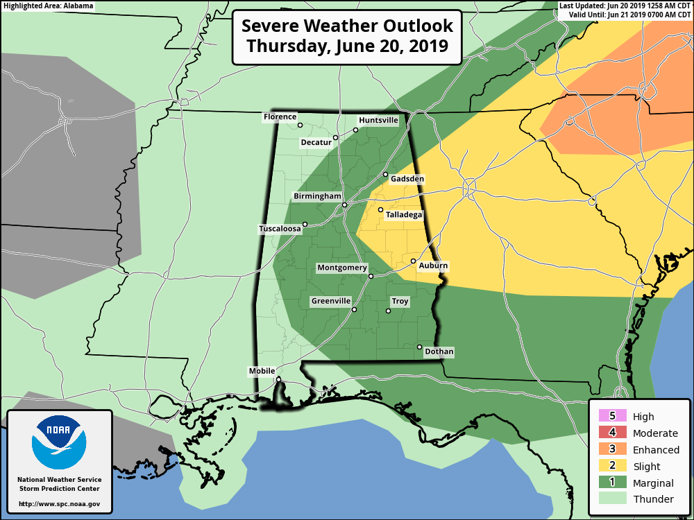
STRONG STORMS REMAIN POSSIBLE LATER TODAY: Once the rain and thunderstorms die off or move out of the area this morning, we should see a little time of mostly quiet weather until more showers and thunderstorms form during the afternoon and evening hours. Much of Central Alabama has been placed in a Marginal Risk for severe storms for today and tonight, with a portion of the eastern parts of the area in a Slight Risk. We could see some larger hail up to golf ball size in diameter along with damaging winds up to 60 MPH with any severe storms that may develop, especially in the Slight Risk locations. The window for stronger to severe storms will be from 12:00 pm to 11:00 pm tonight. Highs will be in the mid-80s to the lower 90s.
HEAT STARTS TO CRANK UP ON FRIDAY: Ridging really starts to build over the southeastern parts of the country and that will bring warmer and more moist air into Central Alabama. A few scattered showers will be possible during the heating of the day, but should quickly die off around or just after sunset. Highs will be in the lower to mid-90s.
THE CENTRAL ALABAMA WEEKEND: High pressure will be set up over the Big Bend area coastline of Florida which will pump more warm and humid air up into Central Alabama on Saturday. There will be scattered showers and storms mainly east of the I-65 corridor while it stays dry west of that. Highs will be in the low to mid-90s. The high stays in place on Sunday which will continue a small chance of scattered afternoon showers and thunderstorms. Highs will be in the mid to upper 90s for most across the area.
FIRST HALF OF NEXT WEEK: A system that will start off the day on Monday out to our west will move through the area later in the day and through the day on Tuesday, bringing us an increased risk of showers and thunderstorms. Monday’s highs will be in the upper 80s to the mid-90s while dropping down into the mid-80s to the lower 90s on Tuesday. Wednesday looks to be a much drier day as high pressure will be off to our west. A few isolated afternoon showers are possible with highs reaching the upper 80s to the lower 90s.
BEACH FORECAST CENTER
Get the latest weather and rip current forecasts for the beaches from Fort Morgan to Panama City on our Beach Forecast Center page. There, you can select the forecast of the region that you are interested in.
ALREADY OFF TO A HOT START IN 2019! ADVERTISE WITH THE BLOG!
We have enjoyed over 10 MILLION page views on AlabamaWx.com so far in 2019! Don’t miss out! We can customize a creative, flexible and affordable package that will suit your organization’s needs. Contact Bill Murray at (205) 687-0782.
E-FORECAST
Get the Alabama Wx Weather Blog’s Seven-Day Forecast delivered directly to your inbox by email twice daily. It is the most detailed weather forecast available in Central Alabama. Subscribe here… It’s free!
CONNECT WITH THE BLOG ON SOCIAL MEDIA
You can find the AlabamaWx Weather Blog on the major social media networks:
Facebook
Twitter
Instagram
WEATHERBRAINS
Don’t forget you can listen to our weekly 90 minute netcast anytime on the web at WeatherBrains.com or on iTunes, Stitcher, or Spotify. This is the show all about weather featuring many familiar voices, including the meteorologists at ABC 33/40.
Category: Alabama's Weather, ALL POSTS, Severe Weather, Weather Xtreme Videos
About the Author (Author Profile)
Scott Martin is an operational meteorologist, professional graphic artist, musician, husband, and father. Not only is Scott a member of the National Weather Association, but he is also the Central Alabama Chapter of the NWA president. Scott is also the co-founder of Racecast Weather, which provides forecasts for many racing series across the USA. He also supplies forecasts for the BassMaster Elite Series events including the BassMaster Classic.Subscribe
If you enjoyed this article, subscribe to receive more just like it.


