Hot, Humid, A Few Scattered Storms
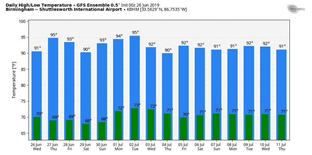
MUGGY SUMMER DAYS: In the moist air over Alabama we have showers on radar at daybreak over parts of North and Central Alabama… they are moving eastward, and won’t last long. More scattered showers or storms could form this afternoon and this evening; odds of any one spot getting wet will be about one in four. Otherwise, expect a mix of sun and clouds today with a high close to 90.
The weather won’t change much tomorrow and Friday, partly sunny both days with “scattered, mostly afternoon and evening showers and thunderstorms”. Highs generally between 89 and 92.
THE ALABAMA WEEKEND: Hot, humid summer weather continues, which is what you expect in late June. We will have a few random, scattered showers and storms around both days, but no way of knowing in advance exactly when and where they form… most will come from 2:00 until 10:00 p.m. Highs for the weekend will remain in the 89 to 92 degree range for most communities.
NEXT WEEK: We will roll with a persistence forecast as we approach the Fourth of July; hot and muggy conditions daily with a mix sun and clouds. And, once again, we will have risk of random, scattered showers or storms each day with highs mostly in the low 90s. See the Weather Xtreme video for maps, graphics, and more details.
TROPICS: All remains very quiet across the Atlantic basin, and tropical storm formation is not expected through next week.
AFRICAN DUST: The Saharan Air Layer (SAL) persists over a decent part of Alabama. I am afraid many don’t understand this; it isn’t especially common, but then again it isn’t too unusual. From time to time in summer dry, dusty air from the deserts of Africa are transported in high levels across the Atlantic and the Caribbean, curving up into the Gulf of Mexico. When the SAL creeps into the Deep South, most of the dust is between 5,000 and 20,000 feet, and the main effect is creating very vivid sky scenes at sunrise and sunset.
Some of the dust could filter down to the surface, and air quality today in the Birmingham is in the “yellow” zone due to particulates. But, understand we are in the yellow zone most summer days; air quality isn’t impacted much by the SAL, which is mostly well off the ground.
The SAL will gradually shift west of Alabama in coming days.
ON THIS DATE IN 1986: Hurricane Bonnie made landfall on the upper Texas coast. A wind gust to 98 mph occurred at Sea Rim State Park. Ace, Texas recorded a total of 13 inches of rain.
BEACH FORECAST: Click here to see the AlabamaWx Beach Forecast Center page.
WEATHER BRAINS: Don’t forget you can listen to our weekly 90 minute show anytime on your favorite podcast app. This is the show all about weather featuring many familiar voices, including our meteorologists here at ABC 33/40.
CONNECT: You can find me on all of the major social networks…
Facebook
Twitter
Instagram
Pinterest
Snapchat: spannwx
I have a weather program this morning at Alberta Elementary in Tuscaloosa… look for the next Weather Xtreme video here by 4:00 this afternoon. Enjoy the day!
Category: Alabama's Weather, ALL POSTS, Weather Xtreme Videos
About the Author (Author Profile)
James Spann is one of the most recognized and trusted television meteorologists in the industry. He holds the AMS CCM designation and television seals from the AMS and NWA. He is a past winner of the Broadcast Meteorologist of the Year from both professional organizations.Subscribe
If you enjoyed this article, subscribe to receive more just like it.


