Strong Storms Forming Already Before Midday
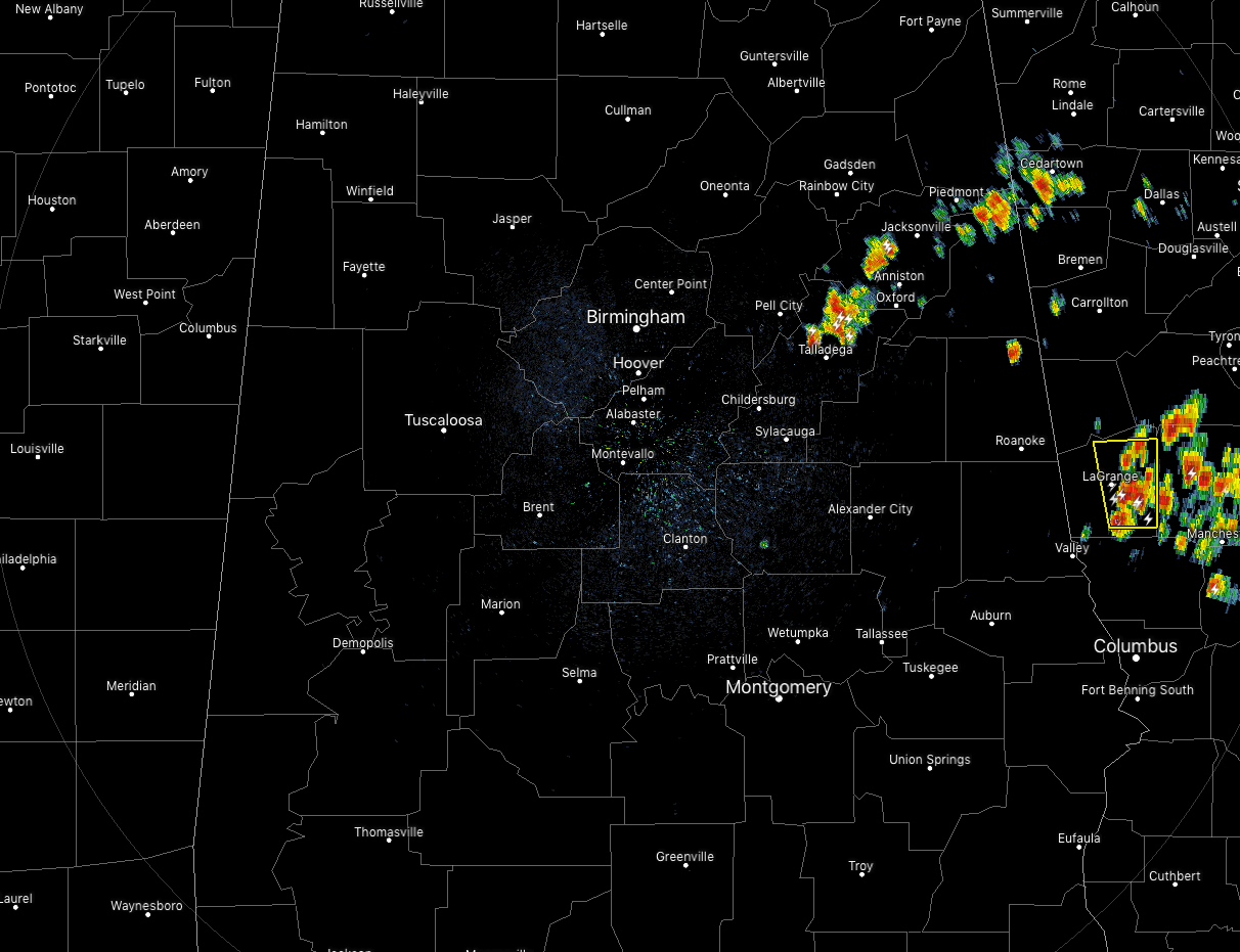
At 11:30 am, we already have some strong thunderstorms that have formed over the northern parts of Talladega County, across much of Calhoun County, and into the extreme southern parts of Cherokee and northern parts of Cleburne counties. These are currently moving to the northwest at 20 MPH. Plenty of lightning, heavy rain and gusty wind can be expected with these cells.
The rest of Central Alabama is dry at this point. Temperatures are in the upper 70s to the upper 80s across the area with Birmingham currently at 86 degrees. The cool spot was Bessemer at 79 while the warm spot was Montgomery at 88 degrees.
We have an upper low situated back to our west over the Arkansas/Louisiana border that will continue to stream gulf moisture up into Central Alabama. Clouds have been building with the heating of the day and scattered to numerous showers and thunderstorms will continue to develop across the area. The highest chances throughout the rest of the day will be across the southern half of the area. Coverage will start to diminish as the sun begins to set and most of the activity should be gone by the start of the overnight hours. Highs will be in the upper 80s to the lower 90s with lows in the upper 60s to the lower 70s. We’ll have to watch as some of these cells could pack a punch with gusty winds and some small hail.
Much of the same story for Sunday… Partly to mostly sunny skies to start but clouds build with the heating of the day. We’ll continue to have our standard chance of scattered afternoon to early evening showers and thunderstorms. Highs will be in the upper 80s to the lower 90s.
THE TROPICS: The Atlantic Basin remains very quiet at this point and no new tropical cyclones are expected to develop within the next five days.
BEACH FORECAST CENTER: Get the latest weather and rip current forecasts for the beaches from Fort Morgan to Panama City on our Beach Forecast Center page. There, you can select the forecast of the region that you are interested in.
ALREADY OFF TO A HOT START IN 2019! ADVERTISE WITH THE BLOG!: We have enjoyed over 10 MILLION page views on AlabamaWx.com so far in 2019! Don’t miss out! We can customize a creative, flexible and affordable package that will suit your organization’s needs. Contact Bill Murray at (205) 687-0782.
E-FORECAST: Get the Alabama Wx Weather Blog’s Seven-Day Forecast delivered directly to your inbox by email twice daily. It is the most detailed weather forecast available in Central Alabama. Subscribe here… It’s free!
CONNECT WITH THE BLOG ON SOCIAL MEDIA: You can find the AlabamaWx Weather Blog on the major social media networks:
Facebook
Twitter
Instagram
WEATHERBRAINS: Don’t forget you can listen to our weekly 90 minute netcast anytime on the web at WeatherBrains.com or on iTunes, Stitcher, or Spotify. This is the show all about weather featuring many familiar voices, including the meteorologists at ABC 33/40.
Category: Alabama's Weather, ALL POSTS
About the Author (Author Profile)
Scott Martin is an operational meteorologist, professional graphic artist, musician, husband, and father. Not only is Scott a member of the National Weather Association, but he is also the Central Alabama Chapter of the NWA president. Scott is also the co-founder of Racecast Weather, which provides forecasts for many racing series across the USA. He also supplies forecasts for the BassMaster Elite Series events including the BassMaster Classic.Subscribe
If you enjoyed this article, subscribe to receive more just like it.


