A Quick Early Afternoon Weather Update For Central Alabama
CONDITIONS JUST AFTER MIDDAY
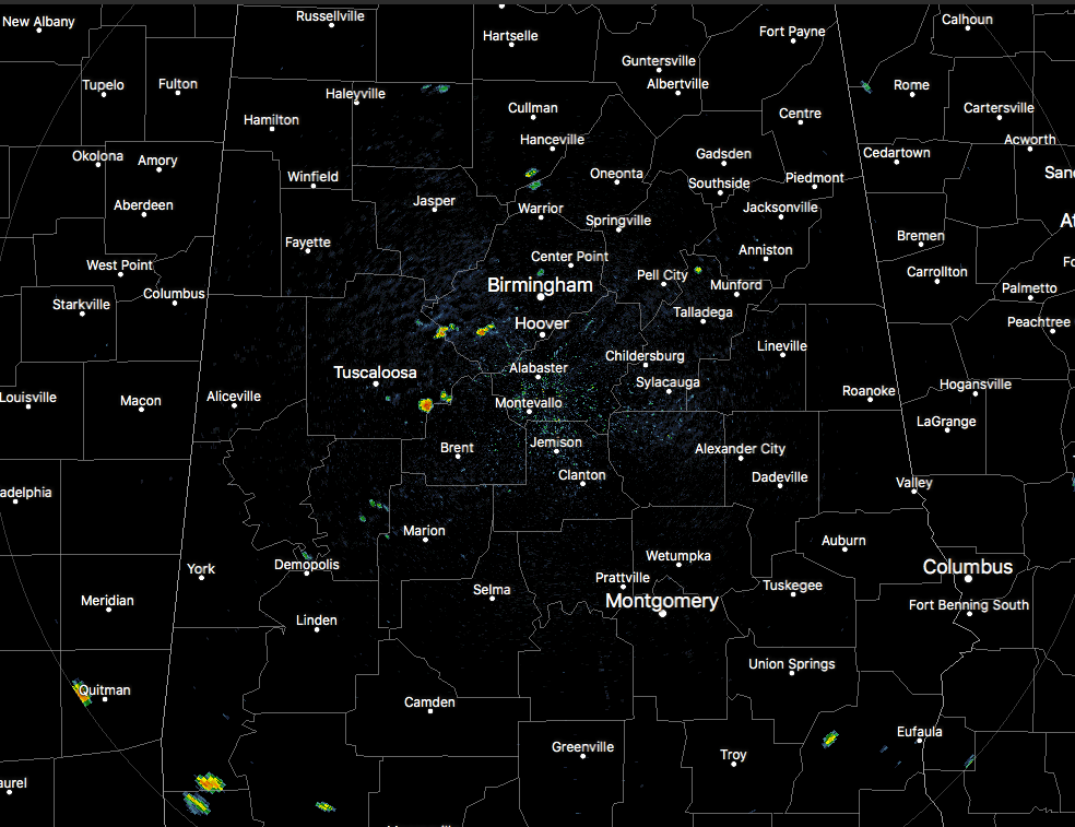
At 1:25 pm, radar still remains rather quiet across Central Alabama, but we do have a few spotty showers that have popped up over the southwestern parts of Jefferson County and the southeastern parts of Tuscaloosa County. The rest of the area has mostly clear to partly cloudy skies at this point. Temperatures are in the mid-80s to the mid-90s across the area. Birmingham was at 93 degrees, trailing behind Demopolis at 94 degrees at the hot spot. Prattville and Alexander City are tied as the cool spots at 86 degrees.
Clouds are increasing with the heating of the day, plus we’ll continue to have clouds building from the south. We’ll have a risk of scattered showers and thunderstorms across the area during the afternoon and evening hours with the risk increasing over the southern parts of the area later in the day due to a band moving up from the south. Afternoon highs will top out in the lower to mid-90s across Central Alabama with heat index values possibly exceeding 105 degrees.
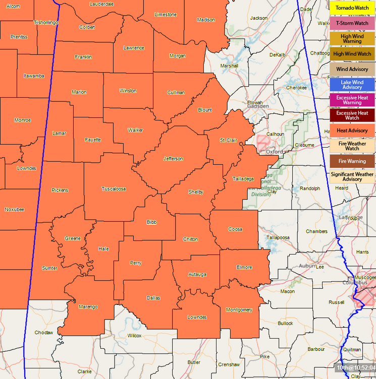
A Heat Advisory continues until 7:00 pm this evening for Autauga, Bibb, Blount, Chilton, Coosa, Dallas, Elmore, Fayette, Greene, Hale, Jefferson, Lamar, Lowndes, Marengo, Marion, Montgomery, Perry, Pickens, Shelby, St. Clair, Sumter, Talladega, Tuscaloosa, Walker, and Winston counties.
For tonight, scattered shower and storm activity will decrease in coverage across much of the area while rain chances will remain elevated across the southern parts of the area due to tropical rain bands from Invest 92L. Overnight lows will drop down into the lower to mid-70s.
A CHECK ON THE TROPICS
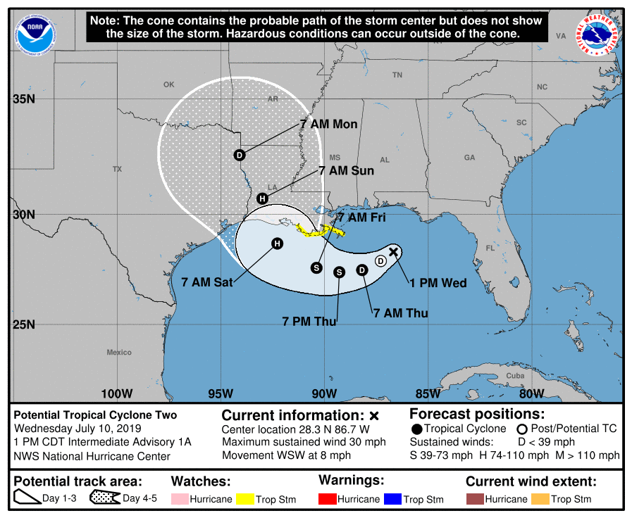
Earlier this morning, the National Hurricane Center changed the name of Invest 92L to Potential Tropical Cyclone 2 as it is likely to become a depression within the next several hours. A Storm Surge Watch is in effect from the mouth of the Pearl River to Morgan City. A Tropical Storm Watch is in effect from the mouth of the Mississippi River to Morgan City. Reconnaissance aircraft are flying through the disturbance at this point and we’ll know what they find in several minutes to an hour.
The forecast cone shows that PTC2 will become a depression later today and eventually strengthen into Tropical Storm Barry by Thursday evening. We also note that the NHC is now expecting Barry to become a hurricane by Saturday morning and making landfall somewhere between Galveston, Texas, and east of Cameron, Louisiana on late Saturday or early Sunday. Currently, the maximum sustained winds are at 30 MPH and it is moving to the west-southwest at 8 MPH.
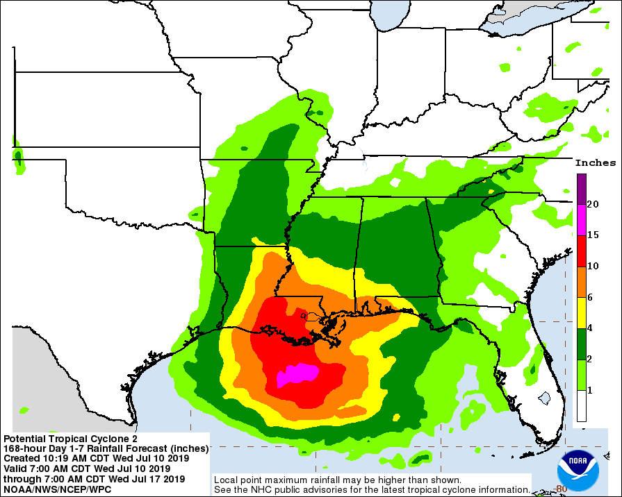
No matter what strength this system becomes during its lifespan, torrential rainfall will occur along the Gulf Coast and inland from Louisiana to the Florida Panhandle. We could see totals ranging from 4.00-15.00 inches through early next week in the yellow, orange, and red shaded areas on the map above. Some locations in Central Alabama could see as much as 2.00-4.00 inches.
For the Alabama Gulf Coast and the beaches of the western Florida Panhandle, we can expect heavy tropical rain from the occasional bands that will move in during tonight, tomorrow, and Friday. Some flooding is possible, along with a few isolated waterspouts and tornadoes. Dangerous rip currents will be likely. Conditions will improve somewhat for the weekend for the Florida Panhandle east of Panama City as rain will become more scattered in nature, but heavier rain will continue to be likely for locations along the Alabama Gulf Coast and over to Destin and Fort Walton Beach.
Category: Alabama's Weather, ALL POSTS, Tropical
About the Author (Author Profile)
Scott Martin is an operational meteorologist, professional graphic artist, musician, husband, and father. Not only is Scott a member of the National Weather Association, but he is also the Central Alabama Chapter of the NWA president. Scott is also the co-founder of Racecast Weather, which provides forecasts for many racing series across the USA. He also supplies forecasts for the BassMaster Elite Series events including the BassMaster Classic.Subscribe
If you enjoyed this article, subscribe to receive more just like it.


