Update On The Gulf Of Mexico Tropical Situation
This morning the National Hurricane Center initiated advisories on “Potential Tropcial Cyclone Two”, which should become Tropical Storm Barry within 36 hours. NHC now expects Barry to become a hurricane before reaching the Louisiana coast Saturday.
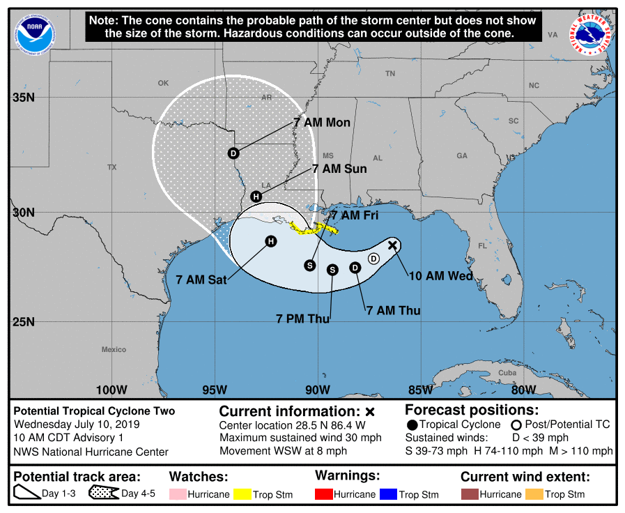
WATCHES ISSUED: A Storm Surge Watch is in effect from the mouth of the Pearl River to Morgan City. A Tropical Storm Watch is in effect from the mouth of the Mississippi River to Morgan City.
A Storm Surge Watch means there is a possibility of life-threatening inundation, from rising water moving inland from the coastline, in the indicated locations during the next 48 hours.
A Tropical Storm Watch means that tropical storm conditions are possible within the watch area, generally within 48 hours.
Here are some key points based on the new NHC package…
*The greatest threat of storm surge and wind damage associated directly with Barry is over the Louisiana coast east of Morgan City to the mouth of the Mississippi River.
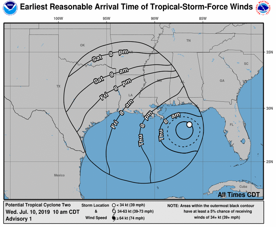
*Don’t focus too much on the center line of the forecast track from NHC… remember, tropical rain bands will extend several hundred miles to the east of the center of circulation.
*For the coasts of Mississippi, Alabama, and Northwest Florida (Bay St Louis to Apalachichola), the main impact will come from occasional bands of heavy tropical rain (with flooding potential) and dangerous rip currents tomorrow and Friday. A few isolated waterspouts and tornadoes are possible as well.
Conditions will improve along the Florida coast over the weekend with storms becoming more scattered in nature, but tropical rain bands will likely continue at times along the Alabama coast Saturday and Sunday. Rain amounts of 6 to 10 inches are forecast for the Mississippi and Alabama coasts, as well as the western tip of the Florida Panhandle around Pensacola. Amounts of 4-6 inches are forecast around Fort Walton Beach and Destin, and totals of 2-4 inches are likely around Panama City Beach and Cape San Blas.
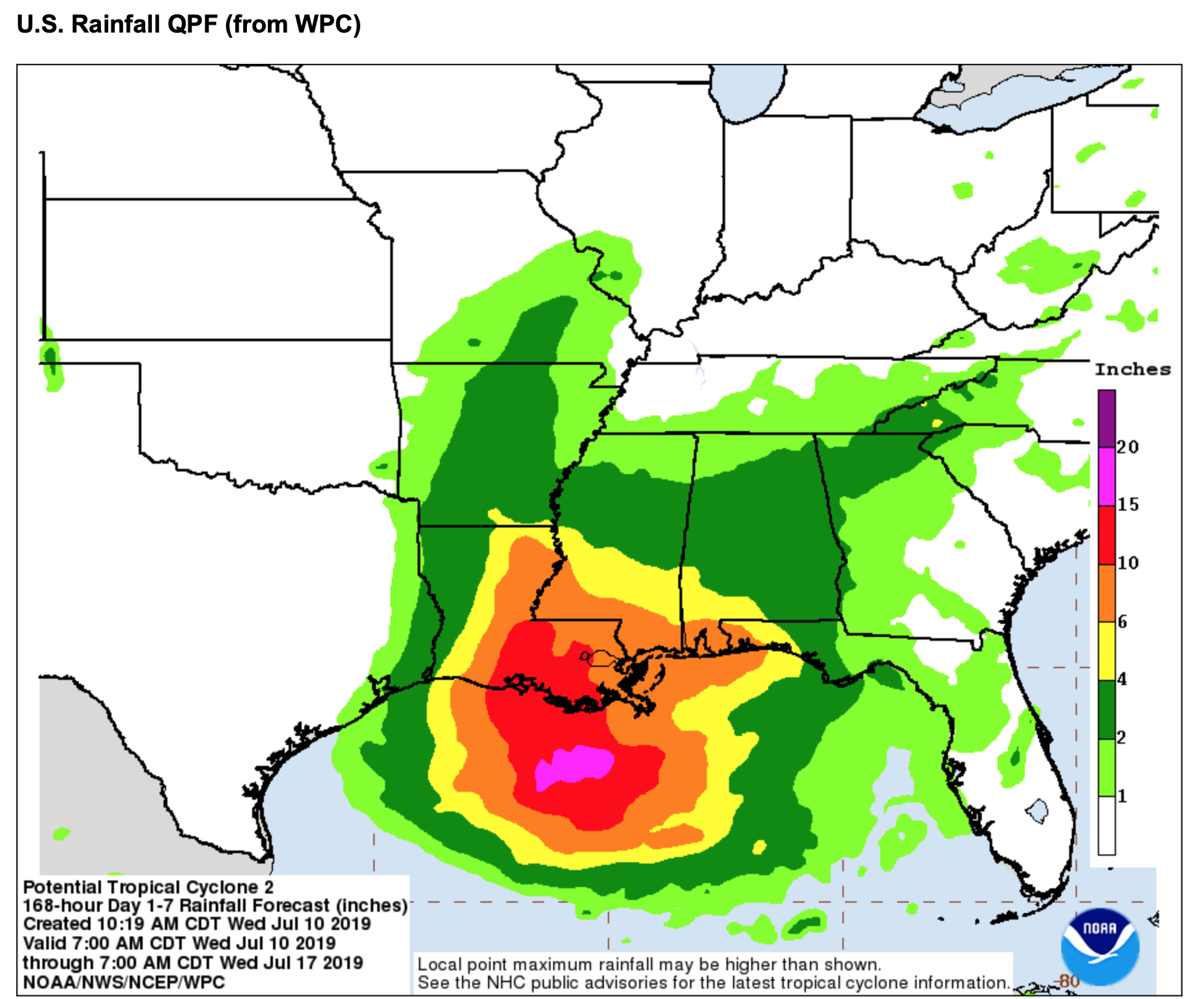
Understand the rain won’t be continuous; there will be some good breaks along the way.
*Rain amounts across most of inland Alabama are expected to be in the 2-4 inch range tomorrow through Sunday with occasional showers and thunderstorms likely. Amounts over the Tennessee Valley should be between 1 and 2 inches. There will be breaks in the rain on these four days, and the sun will pop out at times. But tropical air will cover the state with rain possible at any hour.
*The weather will shift back to a routine summer pattern for the region (including the Gulf Coast) next week as the remnant circulation of Barry is picked up and carried off to the east over the Ohio Valley.
*For those asking if they should cancel a beach trip due to Tropical Storm Barry, I can’t answer that since different people go to the beach for different reasons. It won’t be a good experience if you are simply wanting to swim in the ocean or get lots of sun, but I am the kind of guy who loves a rainy day at the beach. And remember, there will be breaks in the rain.
As always with any tropical system, keep an eye on the blog for forecast changes!
Category: Alabama's Weather, ALL POSTS, Tropical
About the Author (Author Profile)
James Spann is one of the most recognized and trusted television meteorologists in the industry. He holds the AMS CCM designation and television seals from the AMS and NWA. He is a past winner of the Broadcast Meteorologist of the Year from both professional organizations.Subscribe
If you enjoyed this article, subscribe to receive more just like it.


