Tropical Storm Expected To Form In The Gulf Soon
WATCHING DEVELOPMENTS TO THE SOUTH: A disturbance over the Northeast Gulf of Mexico is forecast to become a tropical storm within the next 48 hours, and will have a big impact on Alabama’s weather. We don’t expect much change in our weather situation today; hot and very humid with showers and storms forming this afternoon and tonight in scattered spots. Like yesterday, they will be strong with heavy rain, gusty winds, and very frequent lightning. The high today will be in the 90s, and a heat advisory is in effect for parts of Central and Northwest Alabama.
BIRTH OF BARRY: Here are the key messages on the tropical system forming in the northern Gulf of Mexico:
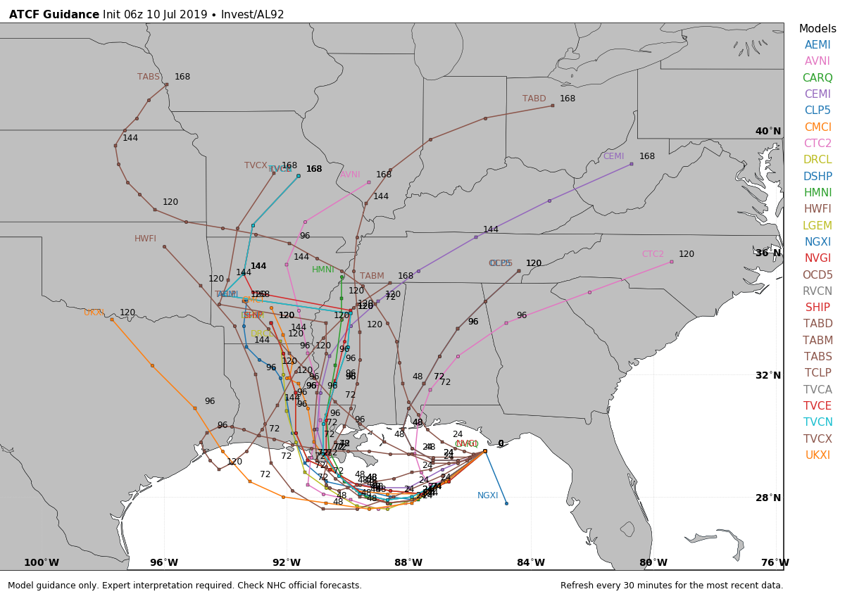
*The system should become Tropical Storm Barry by tomorrow or tomorrow night. It will drift westward through the northern Gulf, followed by a turn northward into Louisiana by Friday or Saturday. For now, we expect it to remain a tropical storm, but the Gulf water is very warm, and we will need to watch for any sign of rapid intensification.
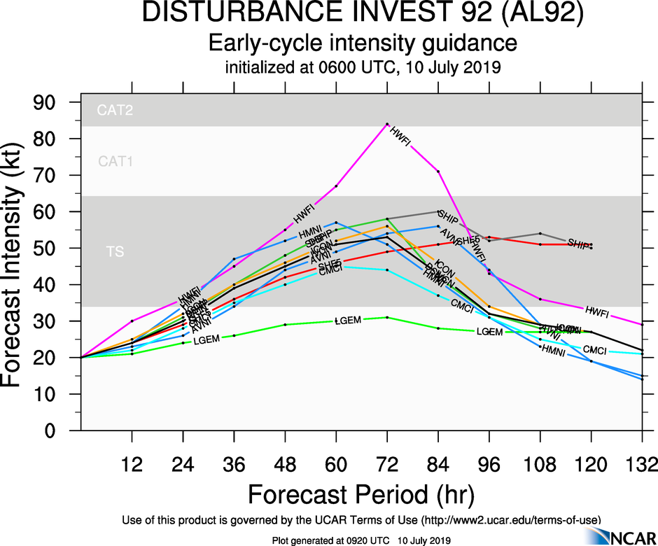
*As you look at the various spaghetti and model plots, don’t focus too much on the center line/track. The rain bands associated with the system will extend a few hundred miles to the east, on the wet side of the storm. Even when the center is south of the Louisiana coast, it will bring bands of heavy tropical rain as far east as the Florida Panhandle.
*For the Gulf Coast, the main impact will be heavy rain/flooding, rough surf/rip currents, gusty winds, and the possibility of a few brief waterspouts or tornadoes. I expect double red flags to be flying along he Central Gulf Coast tomorrow through at least Saturday because of the rip current danger. SPC has much of the coast in a “marginal risk” (level 1/5) through Friday because of the tornado/waterspout potential.
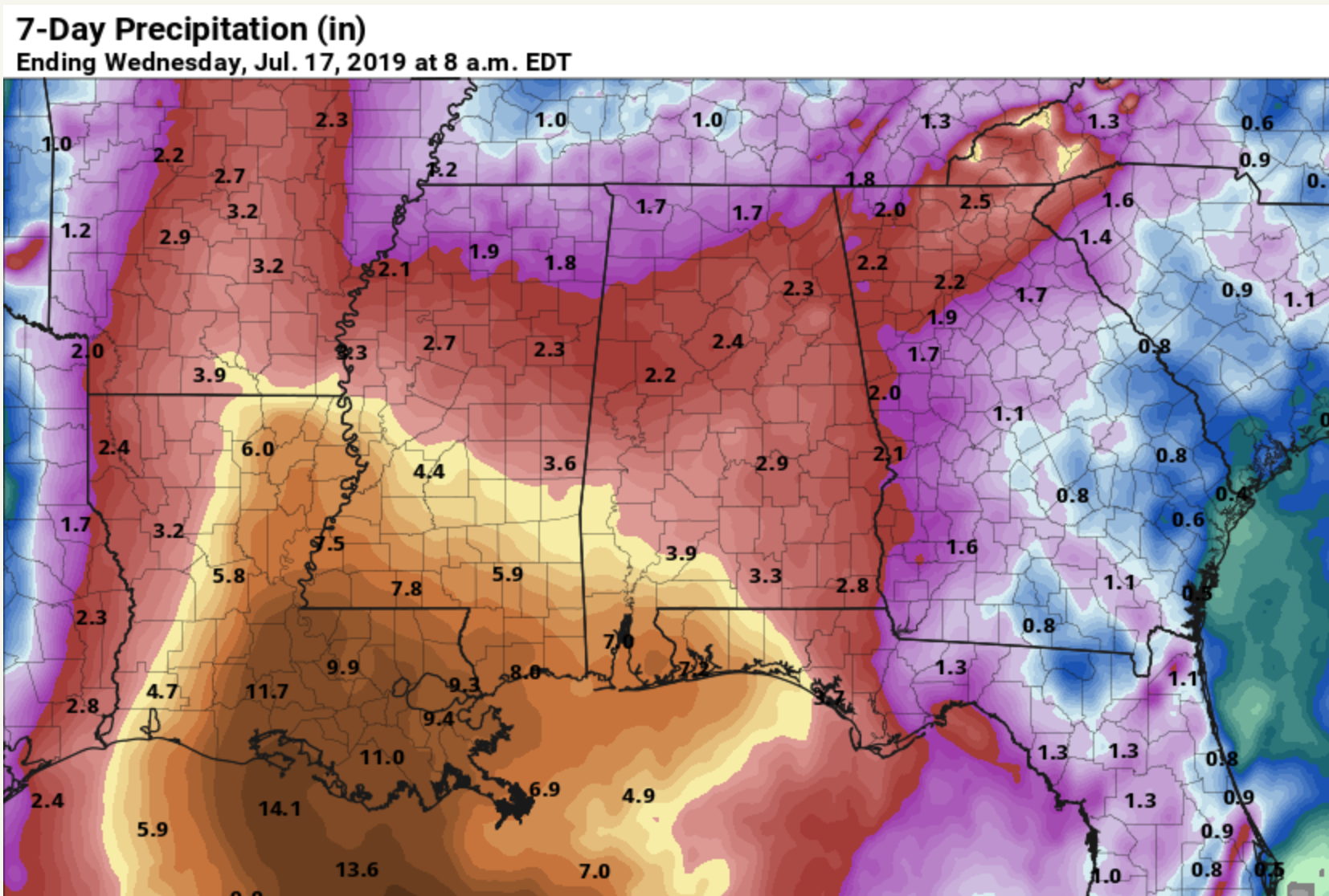
Rain amounts could exceed 5 inches between now and Saturday from Mobile and Gulf Shores to Pensacola and Destin, with 3-5 inches for Panama City Beach and Cape San Blas. But, there will be some good breaks in the rain along the way, and you might see the sun breaking out a few times.
*Conditions will slowly improve over the Gulf Coast from east to west by Sunday and early next week as Barry moves farther inland. Next week should feature routine summer weather on the coast with lots of sun and the usual risk of a passing storm from time to time.
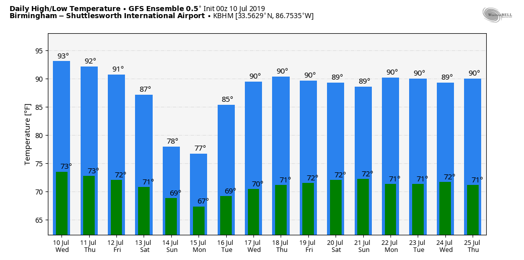
*For inland Alabama, a deep layer of tropical moisture will move northward and cover the region tomorrow through the weekend as the state stays on the wet side of the system. This will mean occasional showers and thunderstorms with lower heat levels. Highs will drop into the 80s, and some places could hold in the 70s Sunday as Barry moves northward just to the west. Like the coast, there will be breaks in the rain, of course, and you could see a little sun at times. Average rain amounts over the northern half of Alabama should be in the 2-3 inch range from now through Sunday.
*For those asking if they should cancel a beach trip due to Tropical Storm Barry, I can’t answer that since different people go to the beach for different reasons. It won’t be a good experience if you are simply wanting to swim in the ocean or get lots of sun, but I am the kind of guy who loves a rainy day at the beach. And remember, there will be breaks in the rain.
NEXT WEEK: The weather gets back to routine summer pattern by mid-week with partly sunny days and “scattered, mostly afternoon and evening showers and thunderstorms”. Highs rise back to around 90 over the latter half of the week. See the Weather Xtreme video for maps, graphics, and more details.
ON THIS DATE IN 2005: Hurricane Dennis made landfall over Santa Rosa Island, Florida on July 10 as a Category 3. Prior to landfall, the hurricane reached Category 4 strength as it approached Florida, attaining its lowest barometric pressure of 930 mb. This ranked Dennis as the strongest hurricane in the Atlantic basin to form before August; however, this record was broken just six days later by Hurricane Emily, which surpassed Dennis and attained Category 5 status. In Alabama, sustained winds reached minimal hurricane force in the interior of the state. In all, 280,000 people in Alabama experienced power outages during the storm.
BEACH FORECAST: Click here to see the AlabamaWx Beach Forecast Center page.
WEATHER BRAINS: Don’t forget you can listen to our weekly 90 minute show anytime on your favorite podcast app. This is the show all about weather featuring many familiar voices, including our meteorologists here at ABC 33/40.
CONNECT: You can find me on all of the major social networks…
Facebook
Twitter
Instagram
Pinterest
Snapchat: spannwx
Look for the next Weather Xtreme video here by 4:00 this afternoon… enjoy the day!
Category: Alabama's Weather, ALL POSTS, Weather Xtreme Videos
About the Author (Author Profile)
James Spann is one of the most recognized and trusted television meteorologists in the industry. He holds the AMS CCM designation and television seals from the AMS and NWA. He is a past winner of the Broadcast Meteorologist of the Year from both professional organizations.Subscribe
If you enjoyed this article, subscribe to receive more just like it.


