

A Stalled Boundary & A Tropical Storm Keeping Us On Our Toes Just After The Midday Hour
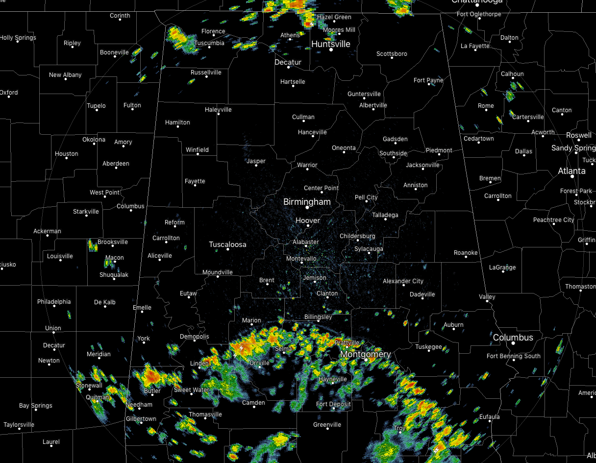
At 1:25pm, we have a convective band moving northward through the southern parts of the area along with a few scattered storms occurring along and just ahead of a stalled surface boundary that is just to the north of the state line. None of these showers and storms are particularly strong at the moment, but we are seeing some lightning with these storms along with pockets of heavy rainfall. Much of the north and central parts of Central Alabama is dry and hot at the moment. Temperatures were in the mid-70s to the lower 90s across the area. Rain-cooled air is causing the temperature at Troy to only be at 75 degrees as the cool spot, while the hot spot is Pell City at 93 degrees. Birmingham was at 90 degrees.
WEATHER FOR THE REST OF YOUR FRIDAY
We’ll have more showers and storms form and build throughout the remainder of the afternoon hours while we still have the impact of daytime heating, but skies will be partly to mostly cloudy if and when you’re not getting rainfall. While there is a good chance of showers and storms for the northern half of the area, storms will be likely in the southern half due to rain bands from Barry. Today’s highs should reach the upper 80s to the lower 90s, but some of those may be held back some due to rain. While much of the activity will diminish during the evening, we could still have a few isolated to scattered storm out there into the late night and overnight hours. Lows will be in the lower to mid-70s.
WET AT TIMES ON SATURDAY
With the land-falling Barry moving northward through Central Louisiana, we’ll start to get more tropical moisture in the form of rain bands across Central Alabama. Also, since we’ll be in the northeast quadrant of the system, we could see a few brief spin-up tornadoes across the southwestern parts of the area. We’ll have scattered to numerous showers and storms with it being more active during the afternoon and evening hours. Highs should top out in the mid to upper 80s, but a few highs could be held back due to rain-cooled air.
BEACH FORECAST CENTER
Get the latest weather and rip current forecasts for the beaches from Fort Morgan to Panama City on our Beach Forecast Center page. There, you can select the forecast of the region that you are interested in.
CONNECT WITH THE BLOG ON SOCIAL MEDIA
You can find the AlabamaWx Weather Blog on the major social media networks:
Facebook
Twitter
Instagram
WEATHERBRAINS
Don’t forget you can listen to our weekly 90 minute netcast anytime on the web at WeatherBrains.com or on iTunes, Stitcher, or Spotify. This is the show all about weather featuring many familiar voices, including the meteorologists at ABC 33/40.
Category: Alabama's Weather, ALL POSTS
About the Author (Author Profile)
Scott Martin is an operational meteorologist, professional graphic artist, musician, husband, and father. Not only is Scott a member of the National Weather Association, but he is also the Central Alabama Chapter of the NWA president. Scott is also the co-founder of Racecast Weather, which provides forecasts for many racing series across the USA. He also supplies forecasts for the BassMaster Elite Series events including the BassMaster Classic.Subscribe
If you enjoyed this article, subscribe to receive more just like it.


