A Quick Update To What Barry Could Bring To Central Alabama

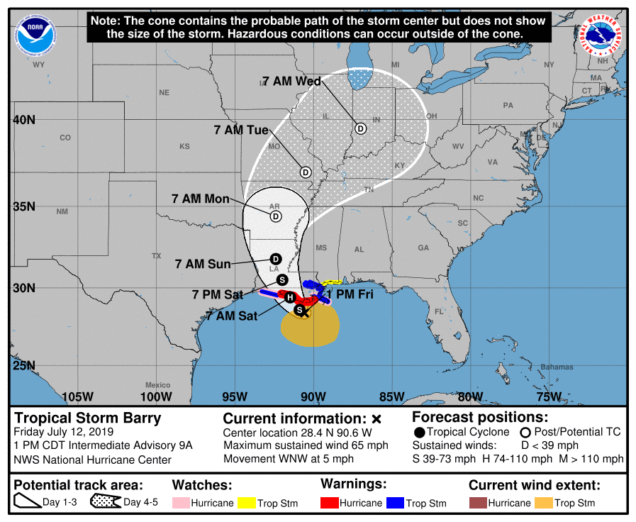
Barry continues to be a strong tropical storm on this late Friday night with maximum sustained winds at 65 MPH and moving to the west-northwest at 4 MPH. Minimum central pressure continues to be around 993 MB. The forecast track remains the same at this point, taking the center of Barry up through Central Louisiana and Central Arkansas through late Monday before starting to really accelerate on Tuesday to the north-northeast passing close to St. Louis. NHC still believes that Barry will strengthen into a Category 1 Hurricane before making landfall on Saturday morning.
With this forecast track, we will see some very needed rainfall across a good bit of Central Alabama while the extreme eastern parts may receive the normal amounts you would see from afternoon scattered thunderstorms. The wettest days for us will be on Saturday, Sunday, and Monday.
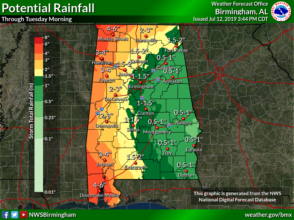
Rainfall amounts through the next several days will end up around 0.50-1.50 inches for the eastern half of the area while the western half could see 1.50-6.00 inches of rain through Tuesday morning as the eastern side of Barry moves northward through the weekend and into the start of next week. While major flooding issues are not expected, there is the possibility of some flash flooding in urban and other poor drainage areas.
As far as the possibility of any tropical type spin-up tornadoes, there will be a marginal risk for those in the southwestern parts of Central Alabama and down into the western parts of South Alabama on Saturday mainly from 11:00 am to 8:00 pm with the main heating of the day. On Sunday, we’ll see a marginal risk of those spin-up tornadoes roughly west of a line from Arley (Winston Co.) to West Blocton (Bibb Co.) to Orrville (Dallas Co.). We’ll continue to see a marginal risk on Monday for locations north and west of the I-59 corridor.
Some strong winds may be felt over the extreme southwestern parts of Central Alabama. There is the potential for 30-40 MPH winds on Saturday as Barry makes landfall and moves northward. Winds up to 20-30 MPH may be felt a little farther east and north.
We’ll continue to have updates throughout the weekend and into the start of next week. While we shouldn’t see major issues from Barry, we still need to be prepared just in case we do have a few tornadoes.
Category: Alabama's Weather, ALL POSTS, Severe Weather, Tropical
About the Author (Author Profile)
Scott Martin is an operational meteorologist, professional graphic artist, musician, husband, and father. Not only is Scott a member of the National Weather Association, but he is also the Central Alabama Chapter of the NWA president. Scott is also the co-founder of Racecast Weather, which provides forecasts for many racing series across the USA. He also supplies forecasts for the BassMaster Elite Series events including the BassMaster Classic.Subscribe
If you enjoyed this article, subscribe to receive more just like it.


