Weather Xtreme: Barry Moves Onshore Later Today
WHAT’S UP WITH BARRY
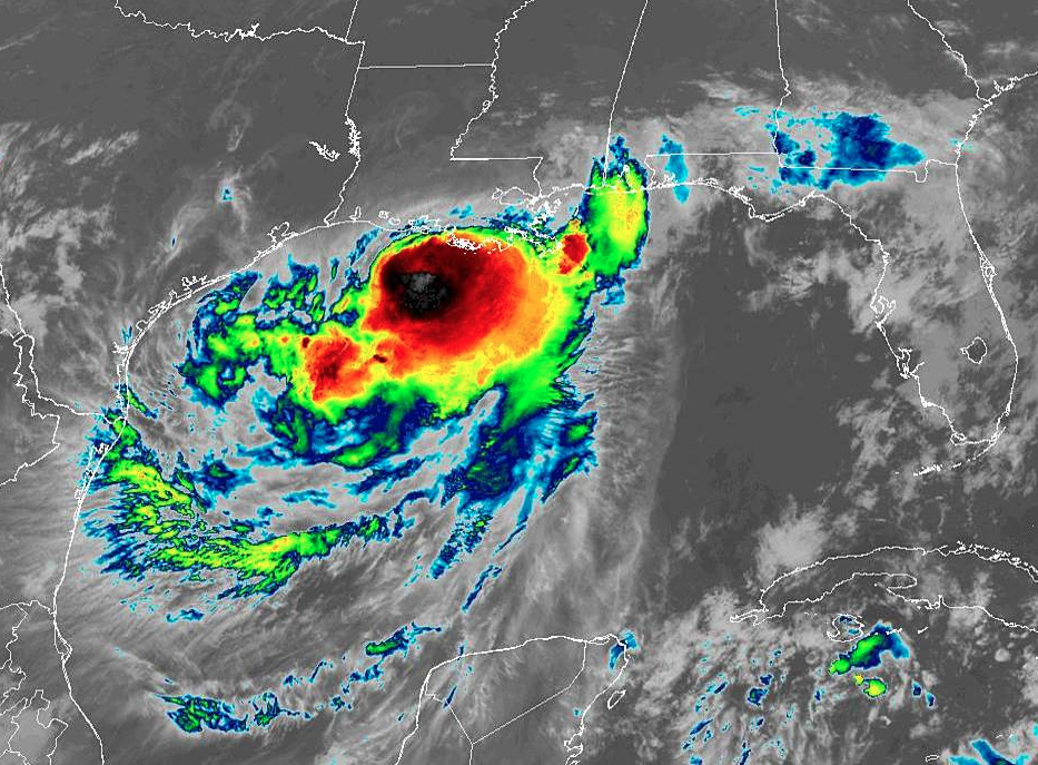
As of 4:00 AM this morning, Barry remains a tropical storm with sustained winds maxing out at 65 MPH, but the National Hurricane Center still expects some strengthening to occur and Barry to become a hurricane prior to the center moving onshore later this morning or just over the midday hour. Pressure has remained at 993 MB for several hours now, and movement is to the west-northwest at 5 MPH. The center was located around 55 miles southwest of Morgan City, Louisiana and about 165 west of the mouth of the Mississippi River.
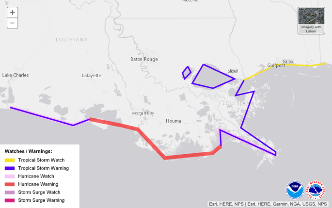
A Hurricane Warning remains in effect from Intracoastal City to Grand Isle. Tropical Storm Warnings are up from the mouth of the Pearl River to Grand Isle, from Intracostal City to Cameron, and for Lake Pontchartrain and Lake Maurepas which includes metropolitan New Orleans.
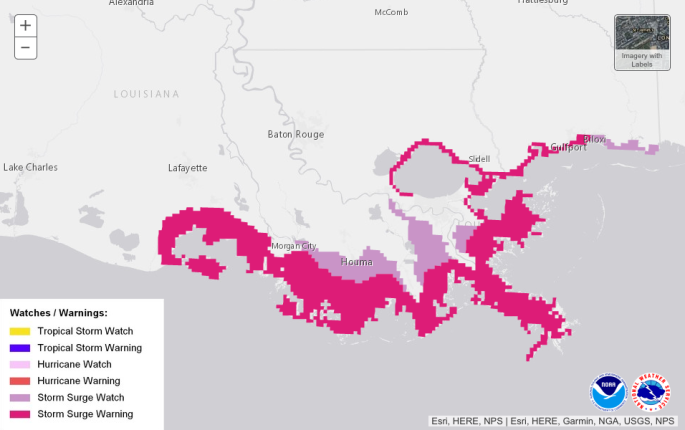
Storm Surge warnings are up from Intracoastal City to Biloxi and for Lake Pontchartrain. Storm Surge Watches are up from Biloxi to the Mississippi/Alabama border.
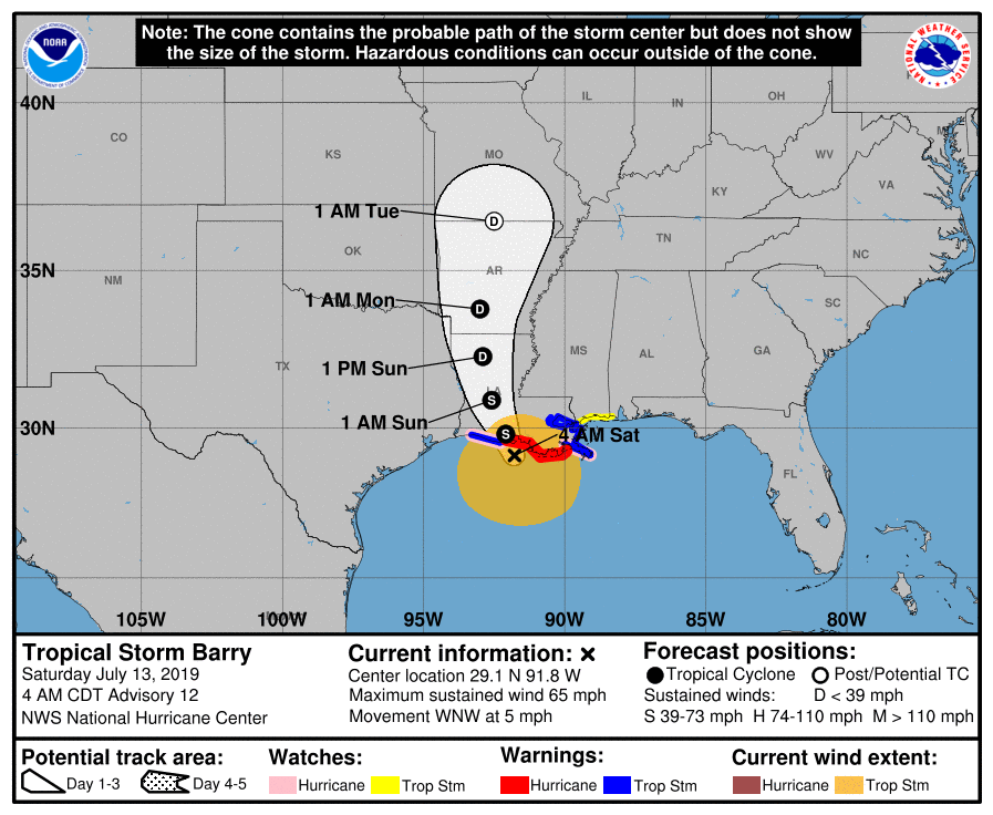
With the latest forecast track, there has been a small shift westward with the center now expected to move through the west-central parts of Louisiana and the west-central parts of Arkansas throughout the weekend and into the beginning of next week.
Of course, there is a slight risk of severe weather up for today across the southern parts of Mississippi and the eastern parts of Louisiana with a marginal risk surrounding that which stretches over to include extreme southwestern Alabama and the western edge of the Florida Panhandle. Tornadoes will be possible on the northeast quadrant of Barry, especially if there is good destabilization of the boundary layer.
Tropical storm force winds are already affecting the Louisiana coastline and there is a chance that the southwestern parts of Alabama could see some of those winds throughout the day today. A Wind Advisory is up for Mobile and Baldwin counties until this evening for the potential of sustained winds of 25 MPH and gusts up to 35 MPH.
A Flash Flood Watch is also up for Choctaw, Washington, Mobile, and Baldwin counties as there is the potential of 3.00-6.00 inches of rainfall associated with Barry.
No storm surge is expected along the Alabama Gulf Coast and the Florida Panhandle, but dangerous rip currents continue due to the large waves generated by Barry. Rip current threat remains high throughout the weekend and at least through Tuesday. Double red flags are up from Dauphin Island to Panama City Beach meaning the waters are closed to the public due to very rough surf and rip currents.
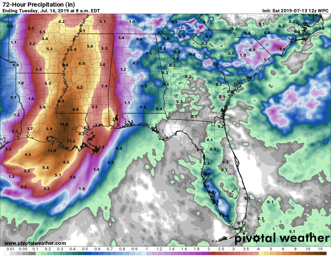
For Central Alabama, we do not expect any widespread flooding issues throughout the event, but there may be some localized flash flooding in urban and other poor drainage locations. Expected rainfall amounts from now until Tuesday morning look to be roughly from 0.50 inches to near 3.00 inches along the Alabama/Mississippi state line. But with high QPF values, we could see some of these storms dump plenty of rain. Up in Black Creek, we got a report of 4.28 inches on Friday with nearly all of that coming in one thunderstorm.
WEATHER FOR TODAY
Barry will be moving onshore, possibly as a minimal hurricane or strong tropical storm later today around the midday hour. For Central Alabama, that means we’ll have numerous to widespread tropical showers and thunderstorms throughout the day, with most of the activity coming during the late morning through the afternoon and early evening hours and especially over the west and southwestern parts of the area. Highs will be in the mid-80s to the lower 90s. Rain will dissipate for much of the area as we get into the late night and overnight hours, but scattered to numerous showers and storms will remain possible over the southwestern parts of the area due to Barry. Lows will be in the lower to mid-70s.
A SUNDAY SOAKER IN STORE
Once again on Sunday, we’ll continue to have numerous to widespread showers and storms across much of the area, with the greatest coverage over the western parts of the area due to Barry. Afternoon highs will be throughout the 80s across the area.
WET AT TIMES ON MONDAY
We’ll continue to keep a good chance of showers and storms on Monday as the remnants of Barry will be moving into the southern parts of Missouri late in the day. Higher coverage will remain in the west and northwestern parts of the area, but chances are elevated for all of the area. Highs will be in the upper 70s to the upper 80s.
TYPICAL SUMMERTIME WEATHER RETURNS TO END OUT THE WORK WEEK
With the remnants of Barry continuing to push farther away, we’ll get back to a more normal summertime pattern for Central Alabama. We’ll have partly to mostly sunny skies on each day with the daily risk of isolated to scattered afternoon showers and thunderstorms. Highs will be starting off in the mid-80s to the lower 90s on Tuesday but will be back up into the lower to mid-90s by Thursday and Friday.
BEACH FORECAST CENTER: Get the latest weather and rip current forecasts for the beaches from Fort Morgan to Panama City on our Beach Forecast Center page. There, you can select the forecast of the region that you are interested in.
ALREADY OFF TO A HOT START IN 2019! ADVERTISE WITH THE BLOG!: We have enjoyed over 10 MILLION page views on AlabamaWx.com so far in 2019! Don’t miss out! We can customize a creative, flexible and affordable package that will suit your organization’s needs. Contact Bill Murray at (205) 687-0782.
E-FORECAST: Get the Alabama Wx Weather Blog’s Seven-Day Forecast delivered directly to your inbox by email twice daily. It is the most detailed weather forecast available in Central Alabama. Subscribe here… It’s free!
CONNECT WITH THE BLOG ON SOCIAL MEDIA: You can find the AlabamaWx Weather Blog on the major social media networks:
Facebook
Twitter
Instagram
WEATHERBRAINS: Don’t forget you can listen to our weekly 90 minute netcast anytime on the web at WeatherBrains.com or on iTunes, Stitcher, or Spotify. This is the show all about weather featuring many familiar voices, including the meteorologists at ABC 33/40.
Category: Alabama's Weather, ALL POSTS, Tropical, Weather Xtreme Videos
About the Author (Author Profile)
Scott Martin is an operational meteorologist, professional graphic artist, musician, husband, and father. Not only is Scott a member of the National Weather Association, but he is also the Central Alabama Chapter of the NWA president. Scott is also the co-founder of Racecast Weather, which provides forecasts for many racing series across the USA. He also supplies forecasts for the BassMaster Elite Series events including the BassMaster Classic.Subscribe
If you enjoyed this article, subscribe to receive more just like it.


