U.S./Canada Tornado Outbreak – May 31, 1985

Source: NWS Cleveland
On the morning of Friday, May 31, 1985, signs were there that a significant outbreak of severe weather was in the offing for Ohio and Pennsylvania. During the overnight hours, a warm front moved northward ahead of an intensifying low pressure system over Minnesota. Morning clouds broke up, giving way to warm sunshine on that last day of May. Temperatures soared and moisture surged into the area. A strong inversion, or cap, formed in the wake of the front. A powerful upper level disturbance was to the west. Winds of 100 mph at 500 millibars and 140 mph at 200 millibars were poised to move across the region.
Thunderstorms formed across Ontario ahead of the cold front around 4 p.m. Thirteen tornadoes would touch down, including four F3s and two F4s. A total of 12 Canadians died in the tornadoes, which were some of the worst in the country’s history. The city of Barrie, about an hour north of Toronto, was hit hard.
Further south, thunderstorms began to develop ahead of the cold front over Ohio and Pennsylvania as the strong heating finally broke the cap. The storms began to rotate. A tornado watch was issued at 4:25 p.m., but tornadoes were a rare occurrence in the Northeast, and people listened with only passing interest to the bulletin on the radio and television.
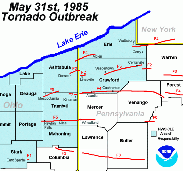
At 5 p.m., a menacing funnel descended from one of those supercell storms just west of the Pennsylvania/Ohio border near Monroe Center, Ohio. This F4 tornado would cut a path directly through Albion, Pennsylvania, destroying twenty square blocks of the town. Twelve people were killed along the 14 mile path.
At 5:17 p.m., another tornado touched down near the Ohio/Pennsylvania border and roared ENE. It cut a 56 mile path across the hills of northwestern Pennsylvania, killing 16 and injuring 125. It was rated as an F4.
Another F4 tornado formed southeast of Erie just before 6:30 p.m. It was on the ground for 28 miles into New York. A farm wagon was blown over one mile.
The strongest and deadliest tornado of the outbreak sizzled down from a storm near Ravenna Arsenal in Ohio and moved east. It destroyed much of the town of Newton Falls, Ohio. In Newton Falls, a police captain became a hero when he climbed on top of the municipal building to manually sound the town siren, undoubtedly saving numerous lives. The tornado roared through Niles, Ohio before continuing into Pennsylvania. Most of the 18 deaths occurred in a strip mall at Niles. The 95% destroyed town of Wheatland, PA looked like “bombed out battlefield” according to Storm Data. The F5 tornado was responsible for 310 injuries.
One of the most remarkable tornadoes was a massive F4 that was on the ground for 69 miles. Dr. Greg Forbes, the severe weather expert for The Weather Channel now, was a professor at Penn State. He watched in amazement on radar as this powerful tornado exhibited a new signature. We know now it was a debris ball. An estimated 90,000 trees were felled in the Moshannon State Forest.
Around 8 p.m., a tornado struck the town of Kane. Four people were killed by this F4 twister.
An F3 in Beaver County, PA killed 9 people just after 8 p.m. the Big Beaver Beaver Borough Shopping Center near West Mayfield was totally destroyed.
The last major tornado of the terrible day killed six as it cut a 19 mile path through Union and Northumblerland Counties.
Tornadoes, especially a swarm of violent one like this, are rare in that part of the country. But it underscores what we always say. When it comes to thunderstorms, expect the unexpected.
It was a terrible afternoon and evening that people in Ohio and Pennsylvania, as well as Ontario, will never forget.
Here is a spectacular account of the horrible event.
– Bill Murray
bill.murray@theweathercompany.com
![]() Follow my weather history tweets on Twitter. I am wxhistorian.
Follow my weather history tweets on Twitter. I am wxhistorian.
Category: Uncategorized


