

1:30 p.m. Alabama Update: Localized Tornado Threat Over West Alabama This Afternoon
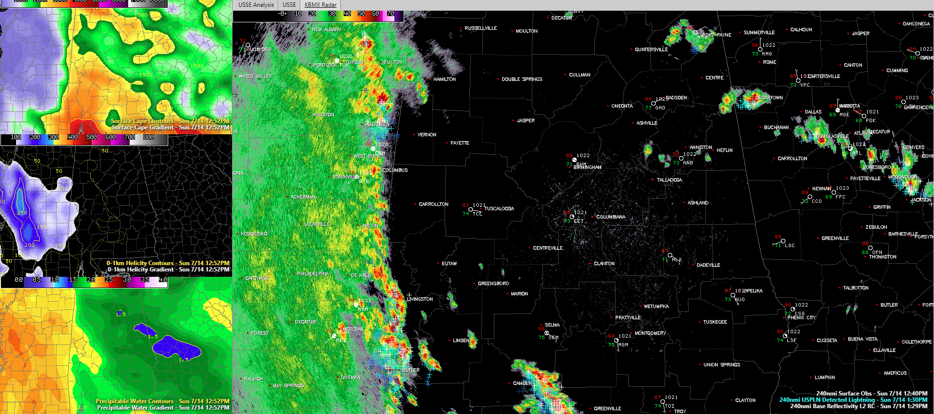
SimuAWIPS graphic showing radar with lightning and surface observations in the larges panel and top to bottom on left: CAPE, 0-1 km helicity and preciptable water
Here is an update on the Alabama weather situation on this Sunday afternoon.
BArry is still a tropical storm this afternoon, just southeast of Shreveport, Louisiana. It is moving north northwest at 9 p.m. Top winds are down to 40 mph and it will probably be downgraded to a tropical depression on the 4 p.m. advisory. Gusty winds of 20-30 mph over eastern Louisiana and southeastern Arkansas.
At least three feeder bands extend from the center of Barry over northwestern Louisiana and western Alabama. Moderate to heavy rain covers nearly every square inch of Mississippi, extending back into southern Louisiana. Very heavy rains are occurring with the storms along the outer feeder ban, which extends from northwestern Tennessee down the eastern side of Mississippi and then into southwestern Alabama.
Several severe thunderstorms are occurring across southeastern Louisiana and southern Mississippi where a tornado watch is also in effect.
More storms have formed over South Alabama over Monroe, Conecuh, Wilcox, Bulter, and Covington Counties. These are moving north and may affect areas deep into Central Alabama this afternoon into this evening.
The concern is that we could get a brief spin-up tornado or damaging wind gust from the storms near the Mississippi border this afternoon. Low-level helicities are not that impressive, but the SPC notes that the storms are moving generally northward in parallel to the line orientation, enhancing their potential for rotation. Lightning is also increasing, which is another sign of intensification. Right now, the storms in Sumter, Choctaw, and Marengo counties are the primary concern. We will be watching the storms over Wilcox and Butler Counties as they move into Dallas and Lowndes Counties as well.
Other storms are forming near I-20 over East Alabama between Lincoln and Heflin, with others over DeKalb County in Northeast Alabama.
Across the state, skies are mostly cloudy west of I-65, with some breaks to the east. Temperatures have warmed into the middle and upper 80s with some low 90s as well. Convective temperatures today were in the lower 90s, so storms may be able to fire in a few spots just on the heating of the day. The convergence associated with the circulation of the tropical storm will help fire others.
Category: Alabama's Weather, ALL POSTS, Severe Weather, Tropical
About the Author (Author Profile)
Bill Murray is the President of The Weather Factory. He is the site's official weather historian and a weekend forecaster. He also anchors the site's severe weather coverage. Bill Murray is the proud holder of National Weather Association Digital Seal #0001 @wxhistorianSubscribe
If you enjoyed this article, subscribe to receive more just like it.


