Hot, Humid Days With Scattered Afternoon Storms
SUN, HEAT, STORMS: Our classic August weather pattern will continue through the weekend. Hot, humid, partly sunny days with “scattered, mostly afternoon and evening showers and thunderstorms”. Most of the storms will come from 12:00 noon until 10:00 p.m., but there is always the risk of a rogue late night or morning shower somewhere. A northwest flow aloft remains in place across the region, and organized thunderstorm areas that form over Arkansas, Missouri, and West Kentucky will roll into North Alabama from time to time.
Where storms do form, they will be heavy this afternoon with potential for strong, gusty winds. Of course, all summer storms pack lots of lightning. Odds of any one spot getting wet today are 30 percent, 50 percent tomorrow, and 30/40 percent Saturday and Sunday. Remember, rain distribution is uneven on summer days; some places will get drenched, other places will get nothing.
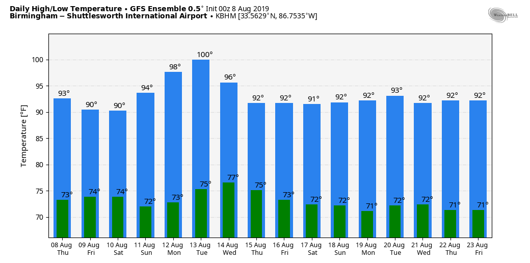
Afternoon highs will be in the low to mid 90s today, and the NWS has a “heat advisory” in effect for parts of North and Central Alabama. But, trust it, it will be hot statewide. Look for mostly low 90s tomorrow through Sunday.
NEXT WEEK: An upper ridge over Texas noses in here early in the week, and output from the GFS ensemble actually suggests parts of the state might make a run at 100 degree heat Monday or Tuesday. The last time it was 100 degrees in Birmingham was on June 26, 2016. We won’t go quiet that high in the forecast, but mid to upper 90s are likely. Heat levels drop during the latter half of the week, and once again we will have the risk of a few scattered showers and storms daily during the peak of the daytime heating process. See the Weather Xtreme video for maps, graphics, and more details.
TROPICS: Still very quiet across the Atlantic basin; tropical storm formation is not expected through the weekend.
ON THIS DATE IN 2007: A tornado bounces across Staten Island and Brooklyn, New York, ripping off roofs and damaging dozens of buildings. The EF-2 twister hop-scotched through Brooklyn’s Bay Ridge and Sunset Park neighborhoods around 6:30 am.
BEACH FORECAST: Click here to see the AlabamaWx Beach Forecast Center page.
WEATHER BRAINS: Don’t forget you can listen to our weekly 90 minute show anytime on your favorite podcast app. This is the show all about weather featuring many familiar voices, including our meteorologists here at ABC 33/40.
CONNECT: You can find me on all of the major social networks…
Facebook
Twitter
Instagram
Pinterest
Snapchat: spannwx
Look for the next Weather Xtreme video here by 4:00 this afternoon… enjoy the day!
Category: Alabama's Weather, ALL POSTS, Weather Xtreme Videos
About the Author (Author Profile)
James Spann is one of the most recognized and trusted television meteorologists in the industry. He holds the AMS CCM designation and television seals from the AMS and NWA. He is a past winner of the Broadcast Meteorologist of the Year from both professional organizations.Subscribe
If you enjoyed this article, subscribe to receive more just like it.


