Heat Levels Back Off Wednesday
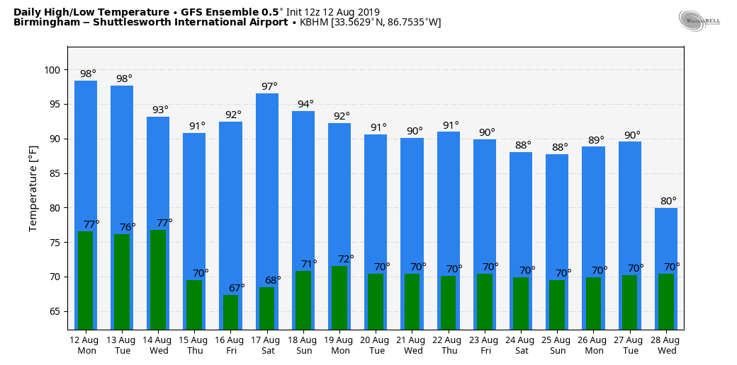
HOT AFTERNOON: Temperatures are generally in the 93-98 degree range across Alabama this afternoon with a partly sunny sky. We have a few widely scattered showers and storms on radar in areas south and east of Birmingham this afternoon; they are moving very slowly, and will dissipate after sunset.
ONE MORE VERY HOT DAY: An “excessive heat warning” has been issued for a decent part of Alabama tomorrow. Temperatures won’t be much different from today; highs should be in the mid to upper 90s, but dew points in the low 70s could push the heat index to 110 in spots. And, like today, afternoon showers should be few and far between.
FYI… the record high for Birmingham tomorrow (August 13) is 103 set in 2007; that record should be safe. The average high for August 13 is 91.
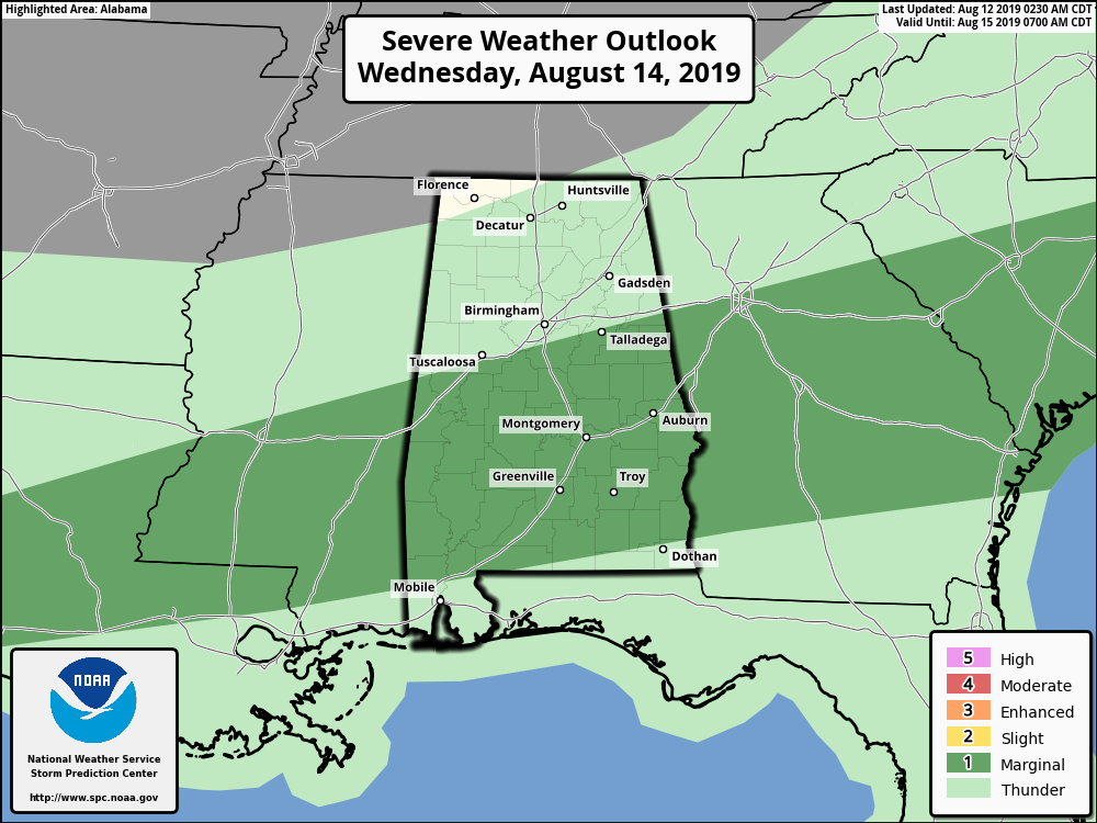
TOMORROW NIGHT/WEDNESDAY: A surface front will approach tomorrow night, and a band of showers and storms could invade the Tennessee Valley of far North Alabama. Then, on Wednesday, we will have a good chance of scattered showers and thunderstorms statewide. Understand we can’t promise rain for everyone, but any one spot stands a 40/50 percent chance of getting wet, especially during the afternoon and evening hours. We also note SPC has a “marginal risk” of severe storms (level 1/5) defined Wednesday for much of Central Alabama; some of the storm could produce strong, gusty winds.
THURSDAY THROUGH THE WEEKEND: The surface front is expected to make it all the way down to the Gulf Coast by Wednesday night, and it looks like much of the state will be in dry for Thursday through the weekend. This means mostly sunny days, lower humidity levels, and cooler nights. Highs will be in the low 90s, and lows in the 60s. Any showers over the weekend should be confined to far South Alabama.
NEXT WEEK: Moist air slowly returns next week, and we will see the return of scattered afternoon and evening showers and storms, especially over the latter half to the week. See the Weather Xtreme video for maps, graphics, and more details.
TROPICS: Once again, the Atlantic basin is quiet, and tropical storm formation is not expected through the week. Only twice in past 20 years has Atlantic had zero named storms between July 15 and August 15: 1999 and 2015. FYI, 1999 still ended up a well above-average Atlantic hurricane season, while 2015 was a below-average Atlantic hurricane season.
ON THIS DATE IN 2004: Hurricane Charley was the third named storm and the second hurricane of the 2004 Atlantic hurricane season. Charley lasted from August 9 to August 15, and at its peak intensity, it attained 150 mph winds, making it a strong Category 4 hurricane on the Saffir-Simpson Hurricane Scale. It made landfall in southwestern Florida at maximum strength, making it the most powerful hurricane to hit the United States since Hurricane Andrew struck Florida in 1992.
BEACH FORECAST: Click here to see the AlabamaWx Beach Forecast Center page.
WEATHER BRAINS: Don’t forget you can listen to our weekly 90 minute show anytime on your favorite podcast app. This is the show all about weather featuring many familiar voices, including our meteorologists here at ABC 33/40.
CONNECT: You can find me on all of the major social networks…
Facebook
Twitter
Instagram
Pinterest
Snapchat: spannwx
Look for the next Weather Xtreme video here by 7:00 a.m. tomorrow…
Category: Alabama's Weather, ALL POSTS, Weather Xtreme Videos
About the Author (Author Profile)
James Spann is one of the most recognized and trusted television meteorologists in the industry. He holds the AMS CCM designation and television seals from the AMS and NWA. He is a past winner of the Broadcast Meteorologist of the Year from both professional organizations.Subscribe
If you enjoyed this article, subscribe to receive more just like it.


