The Heat Is On Through The Weekend
SOME LOCATIONS WILL HIT ONE HUNDRED ON SATURDAY
Do you really expect anything different for the latter part of summer in Central Alabama? We’ll have plenty of sunshine. Afternoon highs will top out in the upper 90s to just over 100 degrees across the area. The good news is that dewpoints will stay in the upper 50s to the lower 60s, so we don’t have to worry about heat index values reaching advisory criteria. With that being said, stay hydrated and take frequent cooling breaks if having to be outside. Skies will be clear with lows in the upper 60s to the mid-70s for tonight.

CODE ORANGE AIR QUALITY ALERT
We have a Code Orange Air Quality Alert for today for the Birmingham metropolitan area as ground-level ozone will reach levels that are unhealthy for sensitive groups. Children and adults with asthma are most at risk under these conditions.
REMAINING HOT & MOSTLY DRY FOR SUNDAY
A weak southerly flow will develop over the area for Sunday which will allow the return of more humid air to the area. This will also bring back the chance of isolated to scattered afternoon showers and thunderstorms, but those should mostly be confined south of a line from Demopolis to Clanton to Alexander City. North of that line should stay dry and hot. Highs will be in the lower 90s to right at 100 degrees across the area. Dewpoints will be up in the mid to upper 60s, so it will definitely feel more sticky outside.
TEMPERATURES BACK OFF A LITTLE WHILE RAIN CHANCES INCREASE
A trough will develop over the southeastern US on Monday which will bring a small increase to our risk of scattered afternoon showers and storms. Those chances will stay a little elevated on Tuesday and Wednesday as well, with each day featuring about 30%-50% chance from northwest to southeast across the area. Highs will be in the lower to mid-90s on each day.
MUCH OF THE SAME FOR THE END OF THE WORK WEEK
A deeper trough will develop over the Great Lakes region for Thursday and Friday that looks to send a cold front down in our direction. At this point, it is uncertain if the front will actually make it into the state. We’ll continue with a chance of scattered afternoon showers and thunderstorms on both days with highs in the lower to mid-90s.
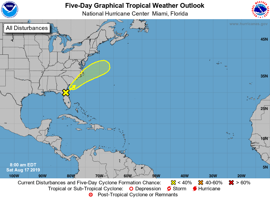
THE TROPICS
We have a weak surface trough that is located over the northeastern Gulf of Mexico and northeastern Florida that will begin to move off to the northeast at 5-10 MPH. There may be some development over the next five days but is only given a 20% chance of developing into a depression by the NHC. Even if there is no to little development, heavy rain with the threat of some flash flooding could occur along the Carolina and Georgia coasts.
BEACH FORECAST CENTER
Get the latest weather and rip current forecasts for the beaches from Fort Morgan to Panama City on our Beach Forecast Center page. There, you can select the forecast of the region that you are interested in.
FREE PREPAREDNESS & SAFETY FESTIVAL FOR THE ENTIRE FAMILY
The National Weather Association Foundation is bringing WeatherReady Fest to the campus of the University of Alabama in Huntsville on September 7, 2019, from 10:00 am to 4:00 pm. This one-day festival will include family-friendly games, fun learning activities, large response vehicles, and enlightening speakers. Local and national celebrities will make special appearances, along with the NWA’s very own, Owlie Skywarn. Over 6,000 attendees showed up in St. Louis for last year’s event… let’s break that record this year. Get your free timed tickets now as they are going fast. More information and a link to the ticket site are available on the festival website at www.weatherreadyfest.com. Hope to see you there!
ALREADY OFF TO A HOT START IN 2019! ADVERTISE WITH THE BLOG!
After a record-setting 2018 with over 19.7 million page views, AlabamaWx.com is already well on its way to setting another record as we’re just topped 12 million page views so far in 2019! Don’t miss out! We can customize a creative, flexible and affordable package that will suit your organization’s needs. Contact Bill Murray at (205) 687-0782.
E-FORECAST
Get the Alabama Wx Weather Blog’s Seven-Day Forecast delivered directly to your inbox by email twice daily. It is the most detailed weather forecast available in Central Alabama. Subscribe here… It’s free!
CONNECT WITH THE BLOG ON SOCIAL MEDIA
You can find the AlabamaWx Weather Blog on the major social media networks:
Facebook
Twitter
Instagram
WEATHERBRAINS
Don’t forget you can listen to our weekly 90 minute netcast anytime on the web at WeatherBrains.com or on iTunes, Stitcher, or Spotify. This is the show all about weather featuring many familiar voices, including the meteorologists at ABC 33/40.
Category: Alabama's Weather, ALL POSTS, Severe Weather
About the Author (Author Profile)
Scott Martin is an operational meteorologist, professional graphic artist, musician, husband, and father. Not only is Scott a member of the National Weather Association, but he is also the Central Alabama Chapter of the NWA president. Scott is also the co-founder of Racecast Weather, which provides forecasts for many racing series across the USA. He also supplies forecasts for the BassMaster Elite Series events including the BassMaster Classic.Subscribe
If you enjoyed this article, subscribe to receive more just like it.


