Heating Up At Midday; Just A Few Showers At This Point
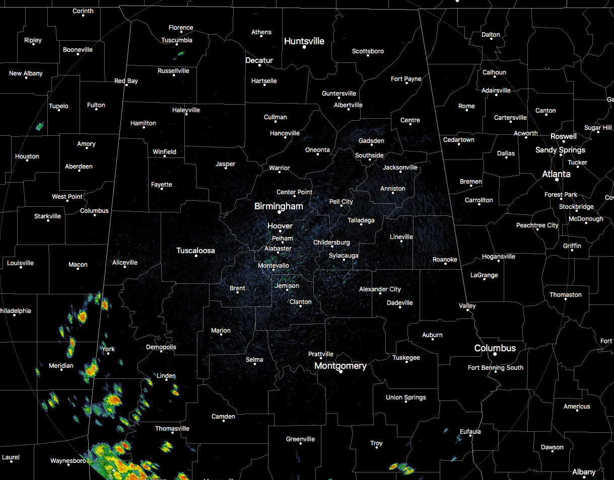
As of 1:15 pm, we have a few showers over the extreme southwestern and extreme southeastern parts of Central Alabama, while the rest of the area is dry and hot at this point. Temperatures at this point were in the mid-80s to the lower 90s across the area. Birmingham was at 90 degrees. Uniontown was the hot spot at 93 degrees. Haleyville and Tuscaloosa were the cool spots at 86 degrees.
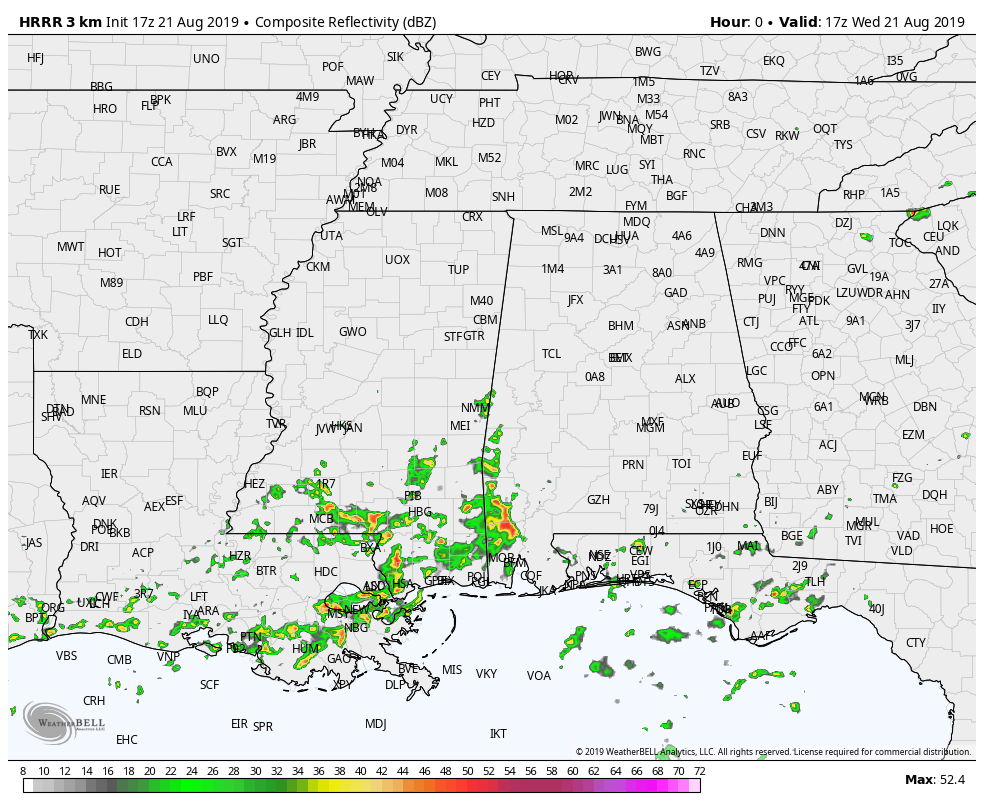
The above HRRR simulated radar animation shows that much of the activity will remain isolated to scattered in nature across the area, with the higher rain probabilities in the southwestern parts of the area. With an area of high pressure just off to the southeast in the southwestern parts of Georgia, I believe that we may have a few more scattered thunderstorms across the area than what the HRRR shows as we have a southerly flow over the area. May have more activity transition to the northwestern parts of the area as there will be a few outflow boundaries present. And with dewpoints in the lower 70s as an average, it will feel rather muggy outside. Highs will top out in the lower to mid-90s. Rain chances across the area will be in the 30-40% range from east to west with most of the activity occurring from roughly 4:00 pm to 10:00 pm. All activity should have come to an end by midnight and we’ll stay dry through the overnight hours. May have a few areas of patchy fog especially where rain has fallen. Overnight lows will be in the lower to mid-70s.
Not much change in the forecast for Thursday as the ridge will keep up in a hot and humid pattern. We’ll continue to have the risk of scattered afternoon and evening showers and thunderstorms across the area with highs reaching the lower to mid-90s.
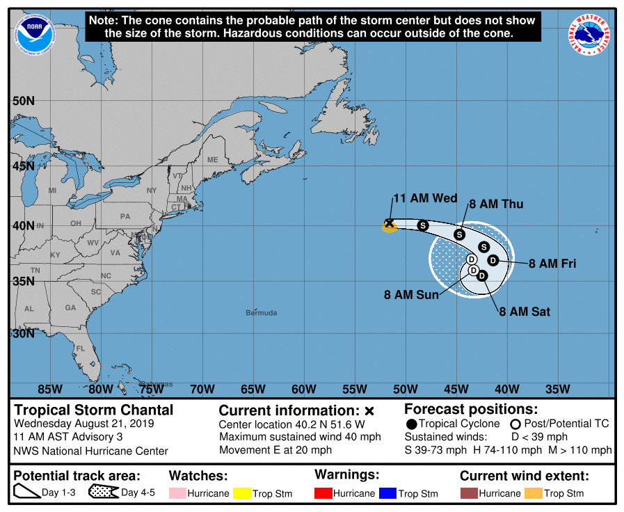
Tropical Storm Chantal continues to move eastward across the Atlantic Ocean with maximum sustained winds at 40 MPH. Gradual weakening is expected as it will begin to get caught up in the periphery of a mid-level anticyclone over the middle of open water. No threat to the Alabama Gulf Coast or the rest of the United States.
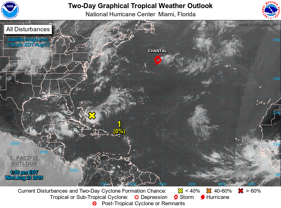
Closer to home, we have a disturbance very close to the Bahamas that we’ll need to watch over the next several days as it will make its way northward along the Atlantic Coasts of Florida, Georgia, and the Carolinas. Some slow development is possible over the next five days, but the NHC is only giving this disturbance a 20% chance of becoming a depression or storm in that time period.
BEACH FORECAST CENTER
Get the latest weather and rip current forecasts for the beaches from Fort Morgan to Panama City on our Beach Forecast Center page. There, you can select the forecast of the region that you are interested in.
WEATHERREADY FEST: A FREE PREPAREDNESS & SAFETY FESTIVAL FOR THE ENTIRE FAMILY
The National Weather Association Foundation is bringing WeatherReady Fest to the campus of the University of Alabama in Huntsville on September 7, 2019, from 10:00 am to 4:00 pm. This one-day festival will include family-friendly games, fun learning activities, large response vehicles, and enlightening speakers. Local and national celebrities will make special appearances, along with the NWA’s very own, Owlie Skywarn. Over 6,000 attendees showed up in St. Louis for last year’s event… let’s break that record this year. Get your free timed tickets now as they are going fast. More information and a link to tickets are available on the festival website at www.weatherreadyfest.com. Hope to see you there!
SIDEWALK FILM FESTIVAL
The 21st Annual Sidewalk Film Festival kicks off on Monday, August 19th, and goes through Sunday, August 25th. Not only will there be great features to be seen, but you can take part in panel discussions, workshops, and even parties. For more information and for tickets, please go to sidewalkfest.com for tickets.
ALREADY OFF TO A HOT START IN 2019! ADVERTISE WITH THE BLOG!
After a record-setting 2018 with over 19.7 million page views, AlabamaWx.com is already well on its way to setting another record as we’re just topped 12.3 million page views so far in 2019! Don’t miss out! We can customize a creative, flexible and affordable package that will suit your organization’s needs. Contact Bill Murray at (205) 687-0782.
E-FORECAST
Get the Alabama Wx Weather Blog’s Seven-Day Forecast delivered directly to your inbox by email twice daily. It is the most detailed weather forecast available in Central Alabama. Subscribe here… It’s free!
CONNECT WITH THE BLOG ON SOCIAL MEDIA
You can find the AlabamaWx Weather Blog on the major social media networks:
Facebook
Twitter
Instagram
WEATHERBRAINS
Don’t forget you can listen to our weekly 90 minute netcast anytime on the web at WeatherBrains.com or on iTunes, Stitcher, or Spotify. This is the show all about weather featuring many familiar voices, including the meteorologists at ABC 33/40.
Category: Alabama's Weather, ALL POSTS
About the Author (Author Profile)
Scott Martin is an operational meteorologist, professional graphic artist, musician, husband, and father. Not only is Scott a member of the National Weather Association, but he is also the Central Alabama Chapter of the NWA president. Scott is also the co-founder of Racecast Weather, which provides forecasts for many racing series across the USA. He also supplies forecasts for the BassMaster Elite Series events including the BassMaster Classic.Subscribe
If you enjoyed this article, subscribe to receive more just like it.


