Showers/Storms To Increase In Coming Days
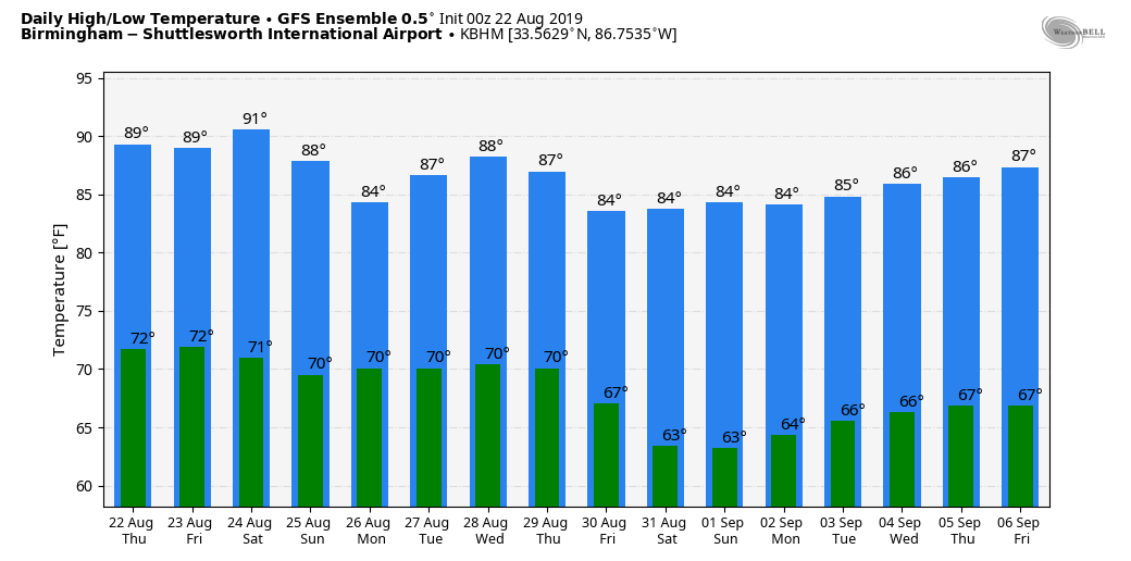
UNSETTLED PATTERN: The air across Alabama will become more unstable in coming days, and moisture levels will rise, setting the stage for an unsettled pattern through the weekend. We expect a mix of sun and clouds today and tomorrow with scattered to numerous showers and thunderstorms, mostly between 12:00 noon and 12:00 midnight. Odds of any one spot getting wet both days are 50 to 70 percent, and afternoon highs will be mostly in the upper 80s.
THE ALABAMA WEEKEND: Not much change; the sky will be occasionally cloudy Saturday and Sunday with a good chance of showers and thunderstorms both days. Once again, most of the rain will come from noon to midnight, but we can’t rule out a late night or morning shower. With only a limited amount of sun, we project a high in the mid 80s. Many places will see beneficial rain.
FOOTBALL WEATHER: A passing shower or storm is very possible for the high school games across Alabama tomorrow evening, but it won’t rain at all stadiums. This means potential for a few lighting delays; temperatures will be in the mid 80s at kickoff.
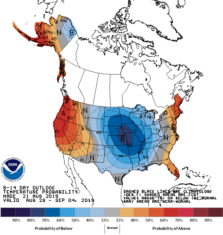
NEXT WEEK: Scattered to numerous showers and thunderstorms will continue Monday and Tuesday, but dry, continental air is expected to move into Alabama over the latter half of the week as a long wave upper trough sets up over the eastern third of the nation. See the Weather Xtreme video for maps, graphics, and more details.
TROPICS: Chantal is now a weak tropical depression over the North Atlantic, far from land. It is expected to dissipate within 36 hours. NHC is also monitoring a wave over the Bahamas; it has only a 20 percent chance of development over the next five days as it moves just off the southeast coast of the U.S.
ON THIS DATE IN 1994: Hurricane John, about 345 miles south of Hilo, Hawaii had winds of 175 mph and pressure at 920 millibars or 27.17 inches of mercury, making it one of the strongest hurricanes ever in the Central Pacific. The 31-day existence made John the longest-lasting tropical cyclone recorded in both the Pacific Ocean and worldwide, surpassing both Hurricane Tina’s previous record in the Pacific of 24 days in the 1992 season and the 1899 San Ciriaco hurricane’s previous world record of 28 days in the 1899 Atlantic season. John was also the farthest-traveling tropical cyclone in both Pacific Ocean and worldwide, with distance traveled of 7,165 miles, out-distancing previous record holders Hurricane Fico in the Pacific of 4,700 miles in the 1978 season and Hurricane Faith worldwide of 6,850 miles in the 1966 Atlantic season.
BEACH FORECAST: Click here to see the AlabamaWx Beach Forecast Center page.
WEATHER BRAINS: Don’t forget you can listen to our weekly 90 minute show anytime on your favorite podcast app. This is the show all about weather featuring many familiar voices, including our meteorologists here at ABC 33/40.
CONNECT: You can find me on all of the major social networks…
Facebook
Twitter
Instagram
Pinterest
Snapchat: spannwx
Look for the next Weather Xtreme video here by 4:00 this afternoon… enjoy the day!
Category: Alabama's Weather, ALL POSTS, Weather Xtreme Videos
About the Author (Author Profile)
James Spann is one of the most recognized and trusted television meteorologists in the industry. He holds the AMS CCM designation and television seals from the AMS and NWA. He is a past winner of the Broadcast Meteorologist of the Year from both professional organizations.Subscribe
If you enjoyed this article, subscribe to receive more just like it.


