Numerous Showers & Storms Throughout The Weekend
TODAY
A surface front will remain to the north of the area today and will set up another day with scattered to numerous showers and thunderstorms mainly during the afternoon and evening hours. With precipitable water values around or just over 2.00 inches today, we may see some issues with localized flash flooding. The most active weather will occur from late morning through the early evening hours, with much of the activity diminishing during the late evening into the late-night hours. There may be a few isolated to scattered showers lingering around during the overnight hours. A few storms may become strong with gusty winds, but there is no threat of organized severe weather today. Highs will top out in the upper 80s to the lower 90s.
SUNDAY
A surface front will stall out over the northern portions of the area, and combine that with a very moist onshore flow, scattered to numerous showers and thunderstorms will become likely during the afternoon hours on Sunday and will continue through the evening hours. The activity should wane during the late-night and overnight hours, but a few isolated to scattered showers and storms will remain possible. Once again, we may have some issues with localized flash flooding due to the heavy rain from some of the larger storms. Afternoon highs will be in the lower 80s to the lower 90s.
MONDAY THROUGH WEDNESDAY
A shortwave is expected to slowly move the southeastern US on Monday through Wednesday which will bring an enhanced risk of showers and thunderstorms on each day. While storms will be likely throughout the entire day on each day, most of the activity will occur during the afternoon and evening hours. A cold front will work through the area on Wednesday, which will bring lower rain chances behind the front, but rain will remain likely out ahead of it. Monday’s highs will be in the 80s throughout the area, but we’re back up into the mid-80s to the lower 90s on Tuesday, and into the upper 80s to the lower 90s for Wednesday.
THURSDAY & FRIDAY
Once a cold front passes through the area, drier air will move into Central Alabama for Thursday and Friday. We’ll have plenty of sunshine with just a few passing clouds. There may be an isolated shower or two somewhere over the southern parts of the area on Friday, but the odds are almost too small to mention. Highs on both days will be in the mid-80s to the lower 90s.
THE TROPICS
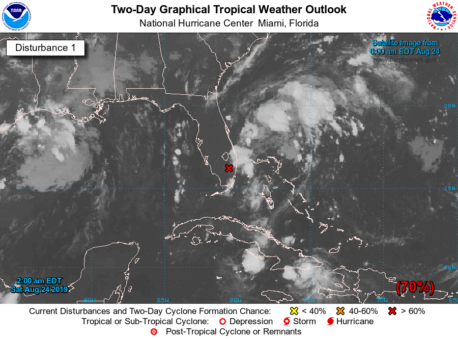
Taking a look at the tropics, we have two disturbances we need to keep our eyes on at the moment. The first one, Invest 98L, was located just northwest of Miami this morning. No significant development is expected today while it slowly drifts to the north over the Florida Peninsula, but conditions will allow for gradual development once the disturbance moves back over the western Atlantic by Sunday. When that happens, there is a high chance that a tropical or subtropical depression will form as it moves northeastward and away from the US coastline.
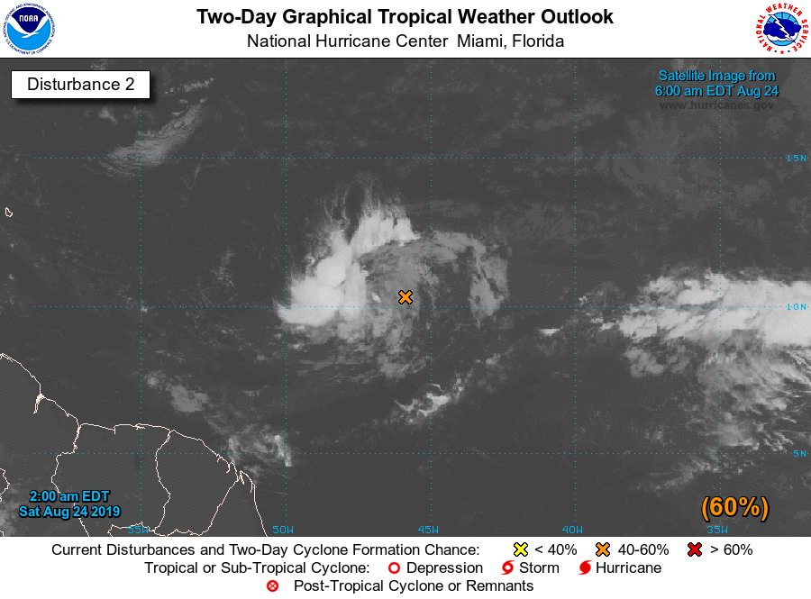
The second disturbance, Invest 99L, was located around 1000 miles east of the Windward Islands and is currently moving westward at 10-15 MPH. Some organization has already been seen and it is likely to become a depression over the weekend or at the beginning of the workweek. Once it reaches the Caribbean Sea by the middle of next week, conditions will not be favorable for further development for a little while. It is too early to tell what happens to Invest 99L after that, but we’ll need to keep our eyes on it as it is expected to continue on a path towards Haiti, the Dominican Republic, Cuba, and eventually South Florida.
WEATHERREADY FEST IS ONLY TWO WEEKS AWAY
The National Weather Association Foundation is bringing WeatherReady Fest to the campus of the University of Alabama in Huntsville on September 7, 2019, from 10:00 am to 4:00 pm. This one-day festival will include family-friendly games, fun learning activities, large response vehicles, and enlightening speakers. Local and national celebrities will make special appearances, including a book signing by our very own James Spann during the morning. Over 6,000 attendees showed up in St. Louis for last year’s event, so let’s break that record this year. Get your free timed tickets now as they are going fast. More information and a link to tickets are available on the festival website at www.weatherreadyfest.com. Hope to see you there!
Category: Alabama's Weather, ALL POSTS, Weather Xtreme Videos
About the Author (Author Profile)
Scott Martin is an operational meteorologist, professional graphic artist, musician, husband, and father. Not only is Scott a member of the National Weather Association, but he is also the Central Alabama Chapter of the NWA president. Scott is also the co-founder of Racecast Weather, which provides forecasts for many racing series across the USA. He also supplies forecasts for the BassMaster Elite Series events including the BassMaster Classic.Subscribe
If you enjoyed this article, subscribe to receive more just like it.


