Beneficial Summer Rain For Alabama
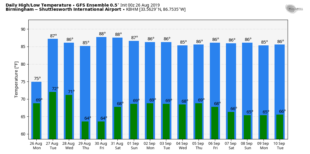
WET DAY: A deep layer of tropical moisture remains over Alabama today, and with an upper trough to the west we expect a wet late summer day with occasional rain and possibly a few thunderstorms. No severe storms, and we don’t expect any flooding issues today (we did have some yesterday around Muscle Shoals, where 5-7 inches of rain came down in only two hours). There is a good chance many communities will hold in the 70s all day because of clouds and rain; the average high at Birmingham on August 26 is 90.
The weather remains unsettled tomorrow; look for scattered to numerous showers and thunderstorms as a surface front approaches from the northwest. The day should be warmer with a high back in the mid 80s as the sun could peek out at times.
WEDNESDAY THROUGH FRIDAY: The front pushes into Alabama late tomorrow night, and drier air filters into the northern counties of the state Wednesday. The best chance of rain on Wednesday will come over the southern half of Alabama; the sky will be mostly sunny to the north. Then, Thursday will be a delightful day with ample sunshine, low humidity, and a cool morning for late August. We project lows early Thursday in the 58-63 degree range for most of North/Central Alabama; the high will be in the 80s.
Moisture returns to Southeast Alabama Friday, where showers are possible, but the northern counties of the state will stay dry with a good supply of sunshine.
LABOR DAY WEEKEND: Moisture levels will rise statewide; still the best chance of showers and thunderstorms on Saturday will be over the southern half of the state, but look out for rain at times Sunday and Monday statewide. This won’t be a “washout”, but a few showers and storms are likely, especially from noon to midnight both days. Highs over the weekend will be mostly in the mid to upper 80s.
REST OF NEXT WEEK: Looks fairly routine for early September with partly sunny days and the risk of scattered, mostly afternoon and evening showers and thunderstorms. Highs will be generally between 86 and 89 degrees. See the Weather Xtreme video for maps, graphics, and more details.
TROPICS: Invest 98L, which is in the Atlantic well east of the South Carolina coast, has a high chance of becoming a tropical or sub-tropical storm over the next 24 hours. It will move northeast, in the general direction of the Canadian maritimes.
Tropical Storm Dorian in the Atlantic is now packing sustained winds of 60 mph, and will pass through the Windward/Leeward Islands after midnight tonight and early tomorrow. Strengthening will be slow due to dry air surrounding the system, but NHC does forecast Dorian to be a category one hurricane as it nears Hispaniola Thursday.
There is a chance that Dorian won’t survive interaction with the mountainous island, but NHC, in their official forecast, moves Dorian through the Bahamas as a tropical depression Friday and Saturday.
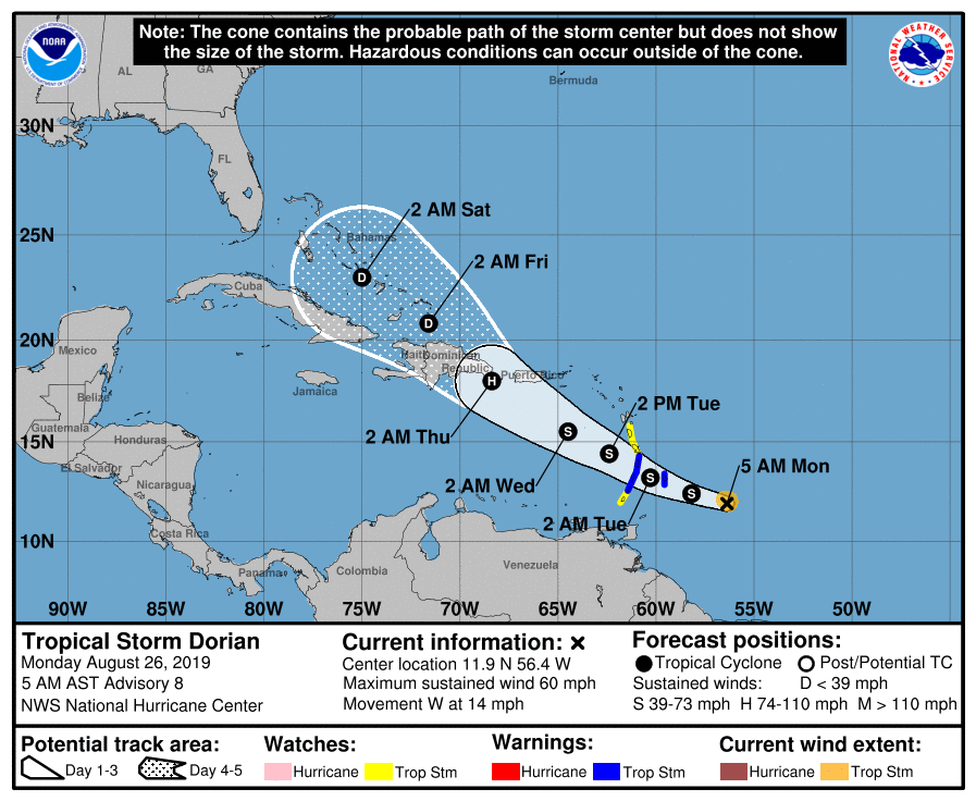
It is still too early to determine what impact, if any, Dorian will have on the contiguous United States; there is little to no skill forecasting specific placement and intensity of a tropical cyclone beyond seven days. The upper air pattern, however, does favor the system curving into the mid-latitude westerlies somewhere around the South Atlantic coast of the U.S. If this happens, it will remain east of Alabama. But again, it is way too early to call.
The rest of the Atlantic basin is quiet.
ON THIS DATE IN 1992: Hurricane Andrew made a second landfall near Burns Point, LA as a Category 3 hurricane. Morgan City, LA recorded sustained winds of 92 mph with a peak gust of 108 mph. Hammond, LA was deluged with 11.92 inches of rain. As Andrew moved inland and weakened, it spawned 47 tornadoes from this date through the 28th from the South to the Mid-Atlantic States.
BEACH FORECAST: Click here to see the AlabamaWx Beach Forecast Center page.
WEATHER BRAINS: Don’t forget you can listen to our weekly 90 minute show anytime on your favorite podcast app. This is the show all about weather featuring many familiar voices, including our meteorologists here at ABC 33/40.
CONNECT: You can find me on all of the major social networks…
Facebook
Twitter
Instagram
Pinterest
Snapchat: spannwx
Look for the next Weather Xtreme video here by 4:00 this afternoon… enjoy the day!
Category: Alabama's Weather, ALL POSTS, Weather Xtreme Videos
About the Author (Author Profile)
James Spann is one of the most recognized and trusted television meteorologists in the industry. He holds the AMS CCM designation and television seals from the AMS and NWA. He is a past winner of the Broadcast Meteorologist of the Year from both professional organizations.Subscribe
If you enjoyed this article, subscribe to receive more just like it.


