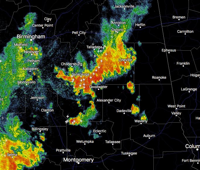
Significant Weather Advisory for Parts of Coosa & Elmore Counties Until 7:45 PM
ALZ036-043-280045-
Coosa AL-Elmore AL-
722 PM CDT Tue Aug 27 2019
…SIGNIFICANT WEATHER ADVISORY FOR NORTHWESTERN ELMORE AND SOUTH
CENTRAL COOSA COUNTIES UNTIL 745 PM CDT…
At 722 PM CDT, Doppler radar was tracking a strong thunderstorm over
Welona, or 10 miles southwest of Rockford, moving southeast at 10
mph.
Winds in excess of 40 mph will be possible with this storm.
Locations impacted include…
Rockford, Jordan Lake, Speed, Lyle, Pentonville, Welona, Ten Cedar
Estates, Titus, Weoka Mills, Holtville and Jordan Dam.
Category: ALL POSTS, Severe Weather
About the Author (Author Profile)
Scott Martin is an operational meteorologist, professional graphic artist, musician, husband, and father. Not only is Scott a member of the National Weather Association, but he is also the Central Alabama Chapter of the NWA president. Scott is also the co-founder of Racecast Weather, which provides forecasts for many racing series across the USA. He also supplies forecasts for the BassMaster Elite Series events including the BassMaster Classic.Subscribe
If you enjoyed this article, subscribe to receive more just like it.


