Significant Weather Advisory for Parts of Autauga & Lowndes Counties Until 8:00 PM
Special Weather Statement
National Weather Service Birmingham AL
729 PM CDT Tue Aug 27 2019
ALZ041-042-280100-
Autauga AL-Lowndes AL-
729 PM CDT Tue Aug 27 2019
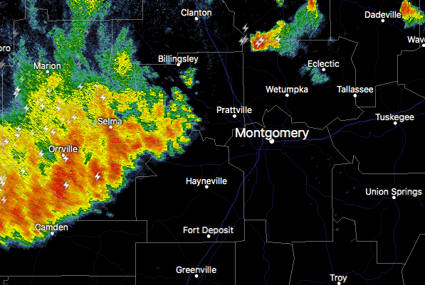
…SIGNIFICANT WEATHER ADVISORY FOR SOUTH CENTRAL AUTAUGA AND LOWNDES
COUNTIES UNTIL 800 PM CDT…
At 729 PM CDT, Doppler radar was tracking strong thunderstorms along
a line extending from Autaugaville to near Dallas Lake. Movement was
southeast at 40 mph.
Winds in excess of 40 mph will be possible with these storms.
Locations impacted include…
Mosses, Hayneville, Autaugaville, White Hall, Gordonville,
Lowndesboro, Benton, Beechwood, Robert F. Henry Lock And Dam, Mount
Willing, Collirene, Farmersville and Fostoria.
Category: ALL POSTS, Severe Weather
About the Author (Author Profile)
Scott Martin is an operational meteorologist, professional graphic artist, musician, husband, and father. Not only is Scott a member of the National Weather Association, but he is also the Central Alabama Chapter of the NWA president. Scott is also the co-founder of Racecast Weather, which provides forecasts for many racing series across the USA. He also supplies forecasts for the BassMaster Elite Series events including the BassMaster Classic.Subscribe
If you enjoyed this article, subscribe to receive more just like it.


