Dry Weather Through Saturday; Lower Humidity
FOGGY START: A dense fog advisory is in effect for Northeast Alabama this morning; visibility is very restricted in many areas, but that fog should dissipate by mid-morning. Otherwise, today will be partly to mostly sunny over most of Alabama; the high will be in the upper 80s this afternoon.
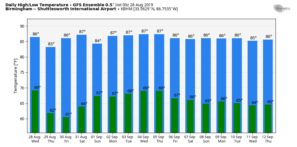
TOMORROW THROUGH THE HOLIDAY WEEKEND: A very dry airmass will cover the state. Look for sunny days, lower humidity, and cooler nights through Saturday. Highs will be in the 87-90 degree range, lows mostly in the 60s. Cooler pockets across North/Central Alabama will visit the 50s early tomorrow morning. Moisture levels will rise a bit Sunday and Monday, and we will mention widely scattered showers both days, but nothing widespread. The sky will be partly sunny with highs in the mid to upper 80s.
REST OF NEXT WEEK: The weather looks generally dry as Dorian stays east of Alabama; mostly sunny days, fair nights, and showers should be few and far between. Highs will be mostly in the 87-91 degree range. See the Weather Xtreme video for maps, graphics, and more details.
FOOTBALL WEATHER: UAB will host Alabama State tomorrow night at Birmingham’s Legion Field… kickoff is at 7:00p CT. The weather will be delightful. A clear sky with temperatures falling from near 85 at kickoff, into the 70s during the second half.
Alabama will take on Duke in the Chick Fil A Kickoff Classic in Atlanta (2:30p CT kickoff)… the game will be played indoors (Mercedes Benz Stadium), but outside the sky will be mostly sunny. Temperatures will peak close to 90 in Atlanta Saturday afternoon.
Auburn travels to Dallas/Fort Worth to take Oregon at AT&T Stadium Saturday evening (6:30p CT kickoff). Temperatures will top out in the mid 90s during the day Saturday with a sunny sky, falling though the 80s during the game.
TROPICAL STORM ERIN: This system is in the Atlantic, well east of the U.S. coast, with sustained winds of 40 mph. It will move northeast, and become post-tropical tomorrow as it approaches Nova Scotia.
TROPICAL STORM DORIAN: Dorian is packing sustained winds of 60 mph, and will move over Puerto Rico today. From there, it is expected to become a hurricane by tomorrow night east of the Bahamas. The latest NHC track puts it near the upper Atlantic coast of Florida late Sunday night, not too far from Daytona Beach.
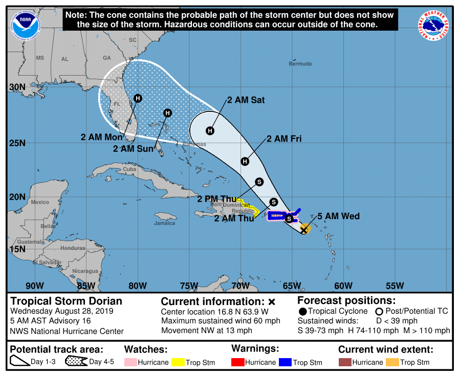
Here are some important points this morning…
*Uncertainty in the intensity forecast late this week remains higher than usual due to a large spread in the model guidance. But there is a chance Dorian could be a significant hurricane as it approaches the Florida Atlantic coast late in the Labor Day weekend.
*The threat of tropical storm or hurricane conditions, along with storm surge, in the northwestern Bahamas and along portions of the Florida east coast (NOT the Gulf Coast) have increased. Residents in these areas should monitor the progress of Dorian and ensure that they have their hurricane plan in place.
*Confidence is growing that Dorian will recurve into the mid-latitude westerlies east of Alabama, keeping our state on the “dry side” of the system. For now we expect little impact, but this is not completely carved in stone.
*There is a chance Dorian could recurve offshore, but ensemble output from computer models suggest this will happen just inland over North Florida and Georgia. There will most likely be some impact across the Carolinas as well.
*There will be little, if any direct impact, along the Gulf Coast over the Labor Day weekend (places like Gulf Shores, Destin, and Panama City Beach. A few showers and storms are possible there, mainly Sunday and Monday, but it is the typical late summer activity.
The rest of the Atlantic basin is quiet.
ON THIS DATE IN 2005: Hurricane Katrina attained Category 5 status on the morning of August 28 and reached its peak strength at 1p CT that day, with maximum sustained winds of 175 mph and a minimum central pressure of 902 mb. It would make landfall the following day as a category three hurricane near Buras, LA, with sustained winds of more than 125 mph.
BEACH FORECAST: Click here to see the AlabamaWx Beach Forecast Center page.
WEATHER BRAINS: Don’t forget you can listen to our weekly 90 minute show anytime on your favorite podcast app. This is the show all about weather featuring many familiar voices, including our meteorologists here at ABC 33/40.
CONNECT: You can find me on all of the major social networks…
Facebook
Twitter
Instagram
Pinterest
Snapchat: spannwx
I have a weather program this morning at Munford Elementary… look for the next Weather Xtreme video here by 4:00 this afternoon. Enjoy the day!
Category: Alabama's Weather, ALL POSTS, Weather Xtreme Videos
About the Author (Author Profile)
James Spann is one of the most recognized and trusted television meteorologists in the industry. He holds the AMS CCM designation and television seals from the AMS and NWA. He is a past winner of the Broadcast Meteorologist of the Year from both professional organizations.Subscribe
If you enjoyed this article, subscribe to receive more just like it.


