Tropical Storm Dorian Near St. Croix, Forecast To Become A Hurricane Soon
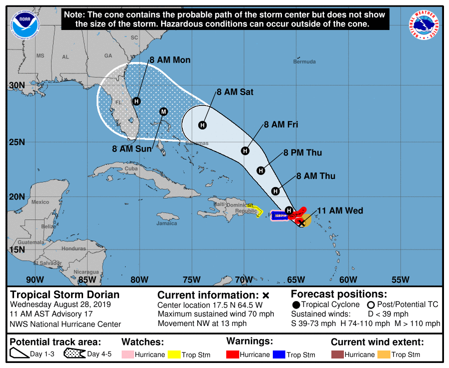
At 1100 AM AST (1500 UTC), the center of Tropical Storm Dorian was located near latitude 17.5 North, longitude 64.5 West (25 miles southeast of St. Croix). Dorian is moving toward the northwest near 13 mph (20 km/h), and this motion is expected to continue for the next day or two. On this track, Dorian should move near the U.S. and British Virgin Islands and then continue over the open Atlantic well east of the southeastern Bahamas.
Maximum sustained winds have increased to near 70 mph (110 km/h) with higher gusts. Dorian is forecast to become a hurricane later today and continue strengthening during the next few days over the Atlantic waters.
Tropical-storm-force winds extend outward up to 80 miles (130 km) primarily to the east of the center.
An Air Force plane just estimated a minimum central pressure of 999 mb (29.50 inches).
WATCHES AND WARNINGS
CHANGES WITH THIS ADVISORY: A Hurricane Warning has been issued for Vieques, Culebra, and the U.S. Virgin Islands.
SUMMARY OF WATCHES AND WARNINGS IN EFFECT:
A Hurricane Warning is in effect for…
* Vieques and Culebra
* U.S. Virgin Islands
* British Virgin Islands
A Hurricane Watch is in effect for…
* Puerto Rico
A Tropical Storm Warning is in effect for…
* Puerto Rico
A Tropical Storm Watch is in effect for…
* Dominican Republic from Isla Saona to Samana
HAZARDS AFFECTING LAND
RAINFALL: Dorian is expected to produce the following rainfall accumulations:
Northern Leeward Islands…1 to 3 inches.
Eastern Puerto Rico, the Virgin Islands, and the northwest
Bahamas…4 to 6 inches, isolated 10 inches
Western Puerto Rico and the central Bahamas…2 to 4 inches
Coastal sections of the Southeast United States…4 to 8 inches,
isolated 10 inches.
This rainfall may cause life-threatening flash floods.
WIND: Hurricane conditions are expected over Vieques, Culebra, and the U.S. and British Virgin Islands today. Tropical storm conditions are expected in Puerto Rico this afternoon and tonight. Tropical storm conditions are still possible in portions of the Dominican Republic tonight and Thursday but are becoming less likely to occur.
Wind speeds atop and on the windward sides of hills and mountains are often up to 30 percent stronger than the near-surface winds indicated in this advisory, and in some elevated locations could be even greater.
SURF: Swells are expected to increase later today across the U.S. and British Virgin Islands and along the southern coasts of Puerto Rico and Hispaniola, and they could cause life-threatening surf and rip current conditions. Please consult products from your local weather office.
Category: Alabama's Weather, ALL POSTS, Tropical
About the Author (Author Profile)
Scott Martin is an operational meteorologist, professional graphic artist, musician, husband, and father. Not only is Scott a member of the National Weather Association, but he is also the Central Alabama Chapter of the NWA president. Scott is also the co-founder of Racecast Weather, which provides forecasts for many racing series across the USA. He also supplies forecasts for the BassMaster Elite Series events including the BassMaster Classic.Subscribe
If you enjoyed this article, subscribe to receive more just like it.


