7 a.m. Update: Dorian Expected to Become a Major Hurricane
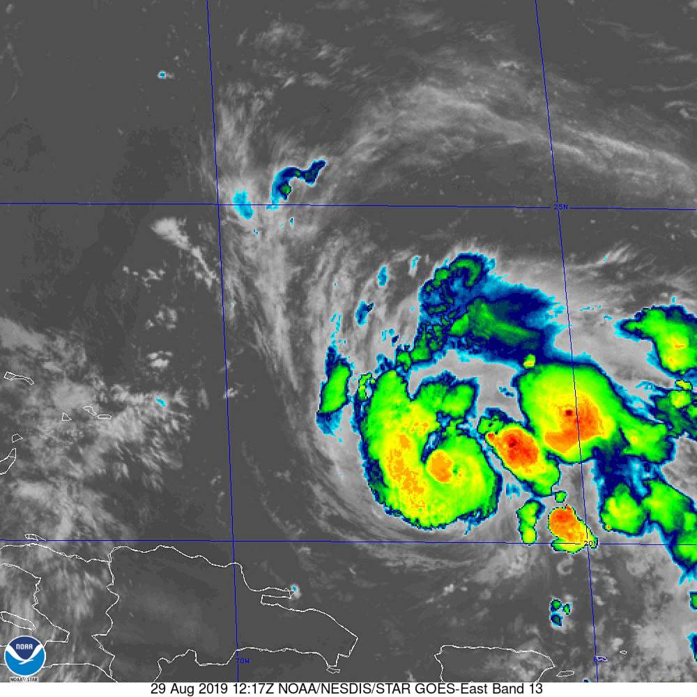
NOAA/NESDIS/STAR GOES ABI BAND 13 OR_ABI-L1b-RadM2-M6C13_G16_s20192411217541_e20192411218010_c20192411218070.nc
Hurricane Dorian has not changed much overnight. Here are the fast facts at 7 a.m.:
———————————————-
LOCATION…20.5N 66.6W
ABOUT 150 MI…240 KM NNW OF SAN JUAN PUERTO RICO
ABOUT 425 MI…685 KM ESE OF THE SOUTHEASTERN BAHAMAS
MAXIMUM SUSTAINED WINDS…85 MPH…140 KM/H
PRESENT MOVEMENT…NW OR 325 DEGREES AT 13 MPH…20 KM/H
MINIMUM CENTRAL PRESSURE…991 MB…29.27 INCHES
Dorian has thrown off the mantle of the Saharan dust and is now in a moist and moistening environment. Sea surface temperatures are running 29C, or around 84F, which is prime for intensification.
There is an area of slightly stronger wind shear to the northwest of the hurricane, lying in its path, so that may temper intensification a bit for the next 24 hours, but shear is generally expected to relax as the hurricane moves northwest and then westward. The hurricane is expected to remain near an upper level anticyclone that will travel westward with it, so steady intensification is likely.
Dorian is expected to become a major hurricane with max winds of 115 mph by Friday afternoon. It could have top winds of 125 mph when it makes landfall on Sunday, most likely on the east coast of Florida. But we caution that everyone along the East Coast of Florida and the Bahamas should be going through their hurricane plans now since it is yet unclear where the hurricane’s impacts will be felt and how. Residents are far north as Charleston, South Carolina and as far south as the Florida Keys should be monitoring the hurricane closely.
Here is the official track forecast:
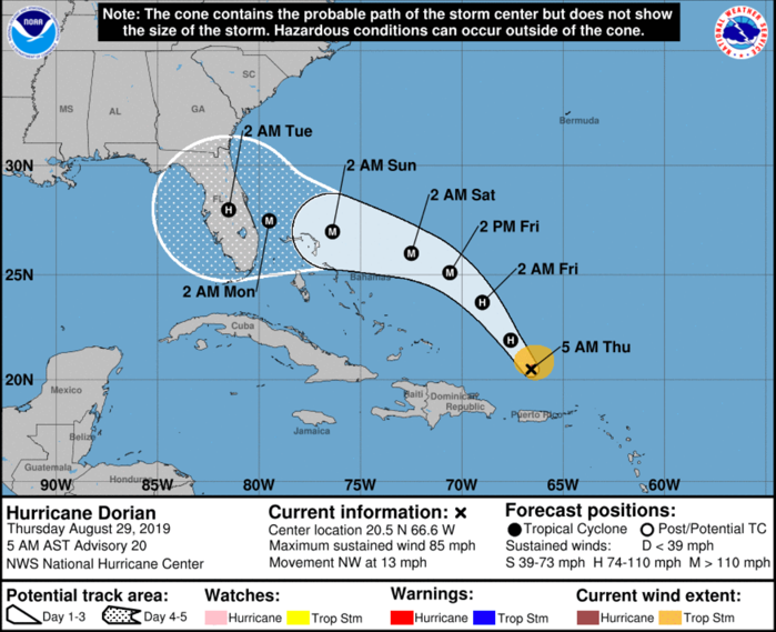
Do not pay too much attention to the exact placement of the black dots. The center of the storm could be anywhere n the opaque and hatched area surrounding those forecast plots. The “cone” represents two-thirds of the average forecast error at each time frame out in the future. Here is a great Washington Post Capital Weather Gang article on the cone.
Five reconnaissance flights will be flown in and around Dorian today. The first should arrive on station around 5 p.m. CDT this afternoon.
While the eventual track of Dorian is uncertain, there is better agreement among the global models this morning that the storm will move into Florida and slow down before turning to the northeast next week. This would reduce the impacts in Alabama, although eastern Panhandle beaches still could see wind and rain. We will be focusing closely on these forecast impact in the days ahead.
About the Author (Author Profile)
Bill Murray is the President of The Weather Factory. He is the site's official weather historian and a weekend forecaster. He also anchors the site's severe weather coverage. Bill Murray is the proud holder of National Weather Association Digital Seal #0001 @wxhistorianSubscribe
If you enjoyed this article, subscribe to receive more just like it.


