Dorian Growing Stronger; To Stay East Of Alabama
REFRESHING MORNING: Many communities across North Alabama have dipped into the cool 50s early this morning; one weather observer in the community of Grantley, in Cleburne County, reports 51 degrees just before daybreak. But we warm up quickly today; look for high around 90 this afternoon with sunshine in full supply. The humidity will stay low statewide.
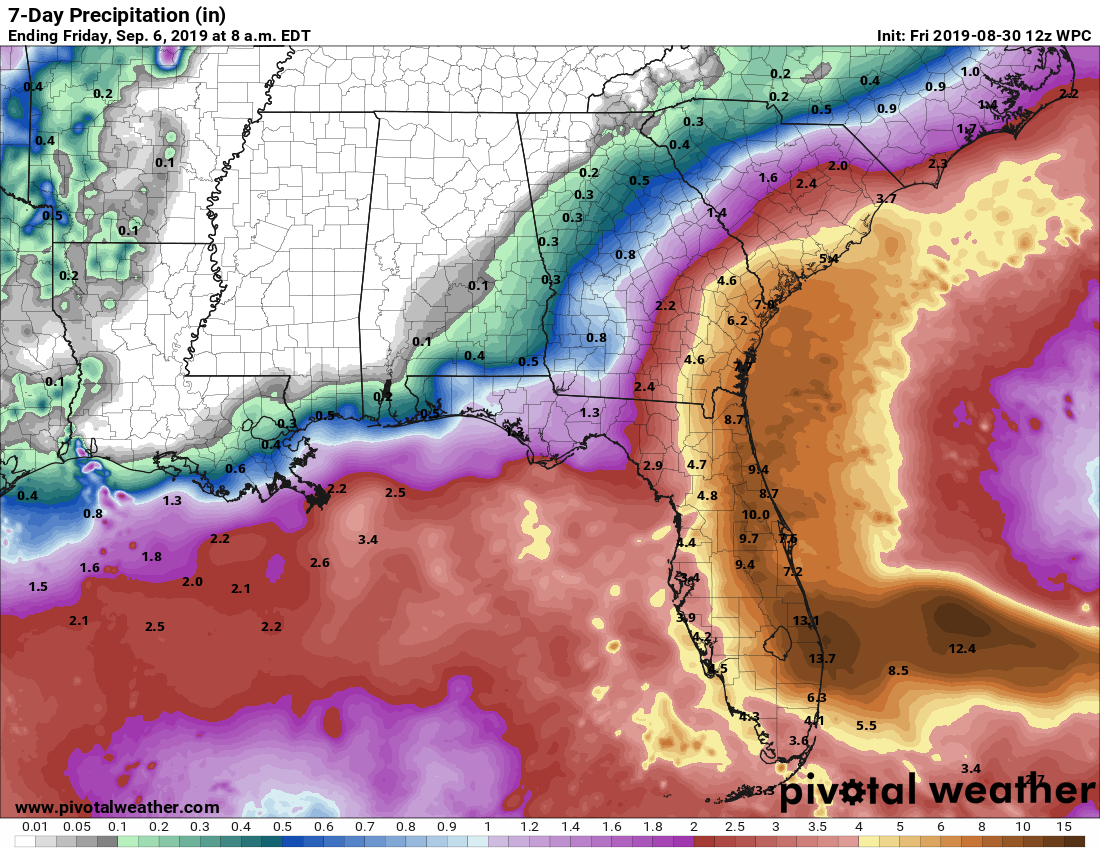
LABOR DAY WEEKEND: The northern half of the state will be dry tomorrow, but a few scattered showers and thunderstorms are possible over South Alabama as moisture levels begin to rise. We will mention a chance of scattered showers statewide Sunday with a mix of sun and clouds… and on Monday the best chance of a shower or storm will be over the southern counties, but they will remain scattered. Highs will be in the 87-90 degree range.
NEXT WEEK: Mostly dry weather is the story for Alabama with mostly sunny days and fair nights. A few showers or storms will be possible over the far southern part of the state, but the rain most likely won’t be too heavy or widespread there. Highs will remain in the 87-90 degree range most days… See the Weather Xtreme video for maps, graphics, and more details.
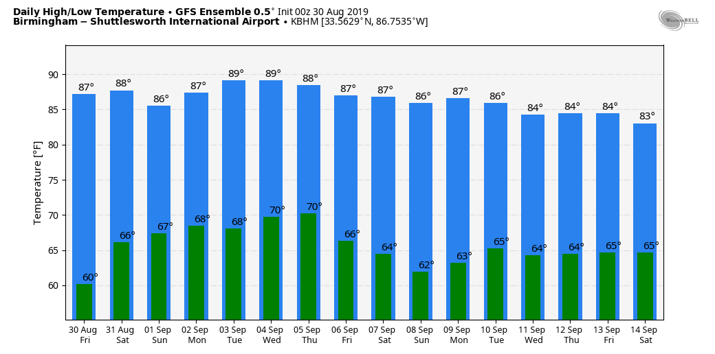
FOOTBALL WEATHER: Perfect weather for high school football games across the state tonight. Clear, low humidity, with temperatures falling from the low 80s at kickoff into the 70s during the second half.
Alabama will take on Duke in the Chick Fil A Kickoff Classic in Atlanta tomorrow (2:30p CT kickoff)… the game will be played indoors (Mercedes Benz Stadium), but outside the sky will be mostly sunny. Temperatures will peak close to 90 in Atlanta tomorrow afternoon.
Auburn travels to Dallas/Fort Worth to take Oregon at AT&T Stadium tomorrow evening (6:30p CT kickoff). Temperatures will top out in the mid 90s during the day Saturday with a sunny sky, falling though the 80s during the game.
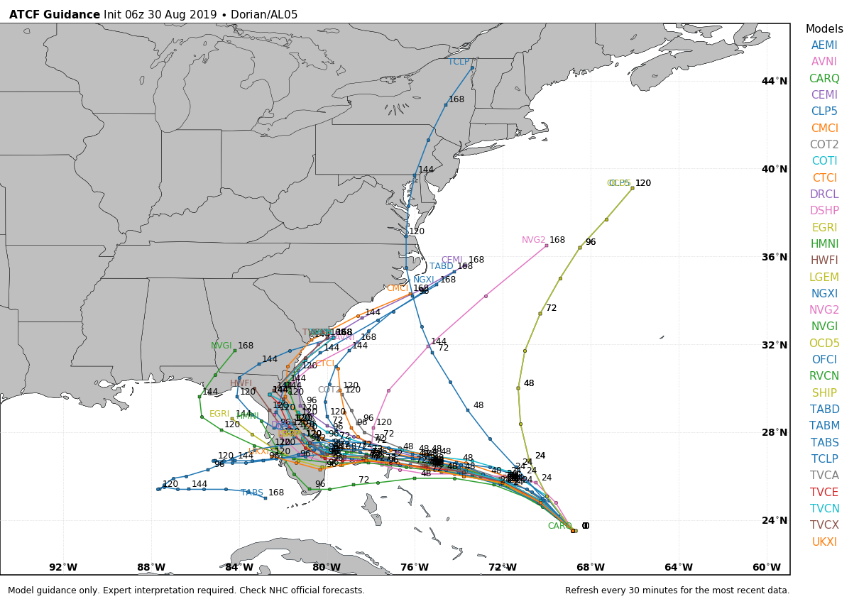
HURRICANE DORIAN: Dorian has sustained winds of 110 mph, and is expected to become a major hurricane today. By the time it reaches the east coast of Florida Monday night, winds are projected to be 140 mph, category four strength. This is dangerous situation for the Florida peninsula, especially for those on the Atlantic coast.
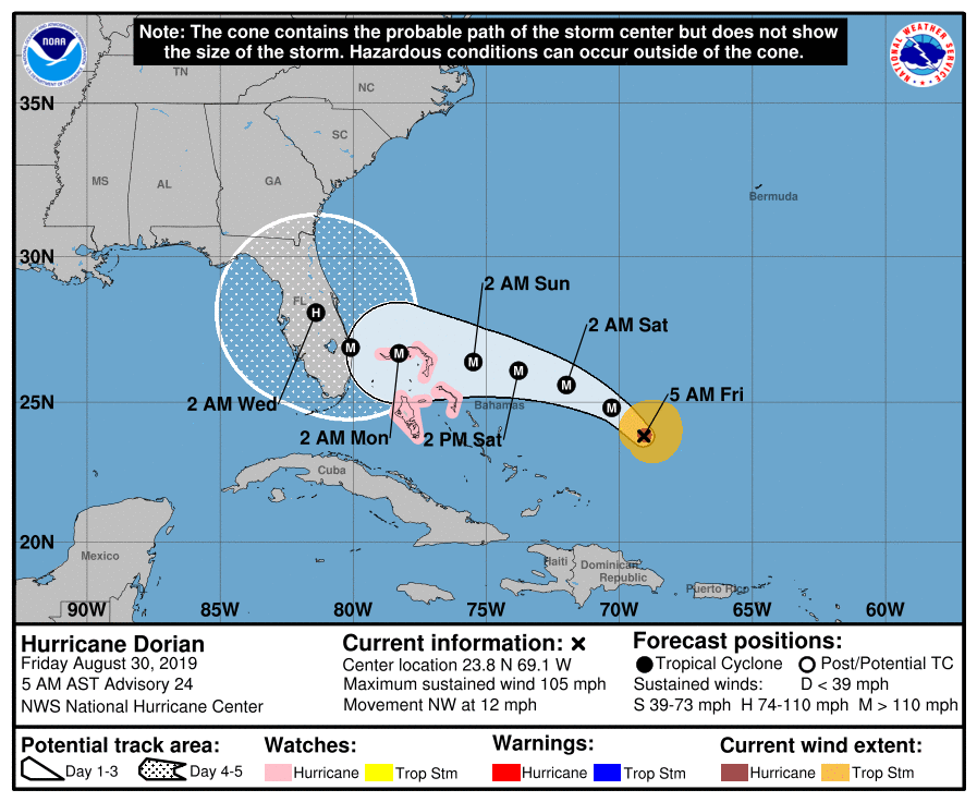
There is now very good agreement in model output that Dorian will turn north, and then northeast, well east of Alabama, and before it gets into the Gulf of Mexico.
Important points…
*A Hurricane Watch is now in effect for the northwestern Bahamas, where the risk of life-threatening storm surge and hurricane-force winds this weekend has continued to increase. Residents should begin to execute their hurricane plans and listen to advice given by local emergency officials.
*The risk of life-threatening storm surge along portions of the Florida east coast has increased, although it is too soon to determine where the highest storm surge will occur. The risk of devastating hurricane-force winds along the Florida east coast and peninsula early next week has also increased, although it is too soon to determine where the strongest winds will occur. Residents should have their hurricane plan in place, know if they are in a hurricane evacuation zone, and listen to advice given by local emergency officials.
*The biggest concern will be Dorian’s slow motion when it is near Florida, placing some areas of the state at an increasing risk of a prolonged, drawn-out event of strong winds, dangerous storm surge, and heavy rainfall.
*The huge storm surge will come along and north of where the center makes landfall on the east coast of Florida early next week.
*Don’t focus too much on the dots on the NHC forecast track… remember, the impact (wind, rain, etc) of the hurricane will extend out a couple of hundred miles.
*If you are planning a trip to Disney World in Orlando for Labor Day weekend, the weather will be routine Saturday and Sunday with sun and scattered thunderstorms. Conditions deteriorate Monday, and there will most likely be driving rain and high wind there by Monday night and Tuesday.
*There will be no direct impact on Alabama, or the Central Gulf Coast (places like Gulf Shores, Destin, Panama City Beach).
Elsewhere in the tropics, a new tropical wave is emerging off the coast of Africa; it could show slow development over the next five days as it moves westward.
ON THIS DATE IN 2002: Typhoon Rusa dumps torrential rains across South Korea, causing widespread flooding from the 30th through September 1st. Typhoon Rusa was the most powerful typhoon to hit South Korea since 1959. Nearly 90,000 people were evacuated. The province of Gangwon was hit the hardest, where an estimated 36 inches of rain fell in less than 48 hours. The torrential rains flooded nearly 36,000 homes. The Korean Defense Ministry reported flood waters submerged 16 jet fighters and 622 military buildings and facilities at Kangnung airbase.
BEACH FORECAST: Click here to see the AlabamaWx Beach Forecast Center page.
WEATHER BRAINS: Don’t forget you can listen to our weekly 90 minute show anytime on your favorite podcast app. This is the show all about weather featuring many familiar voices, including our meteorologists here at ABC 33/40.
CONNECT: You can find me on all of the major social networks…
Facebook
Twitter
Instagram
Pinterest
Snapchat: spannwx
I have a weather program this morning at Saks Elementary… look for the next Weather Xtreme video here by 4:00 this afternoon. Enjoy the day!
Category: Alabama's Weather, ALL POSTS, Weather Xtreme Videos
About the Author (Author Profile)
James Spann is one of the most recognized and trusted television meteorologists in the industry. He holds the AMS CCM designation and television seals from the AMS and NWA. He is a past winner of the Broadcast Meteorologist of the Year from both professional organizations.Subscribe
If you enjoyed this article, subscribe to receive more just like it.


