Hurricane Dorian Continues to Strengthen…Poses a Significant Threat to Florida and the Northwestern Bahamas
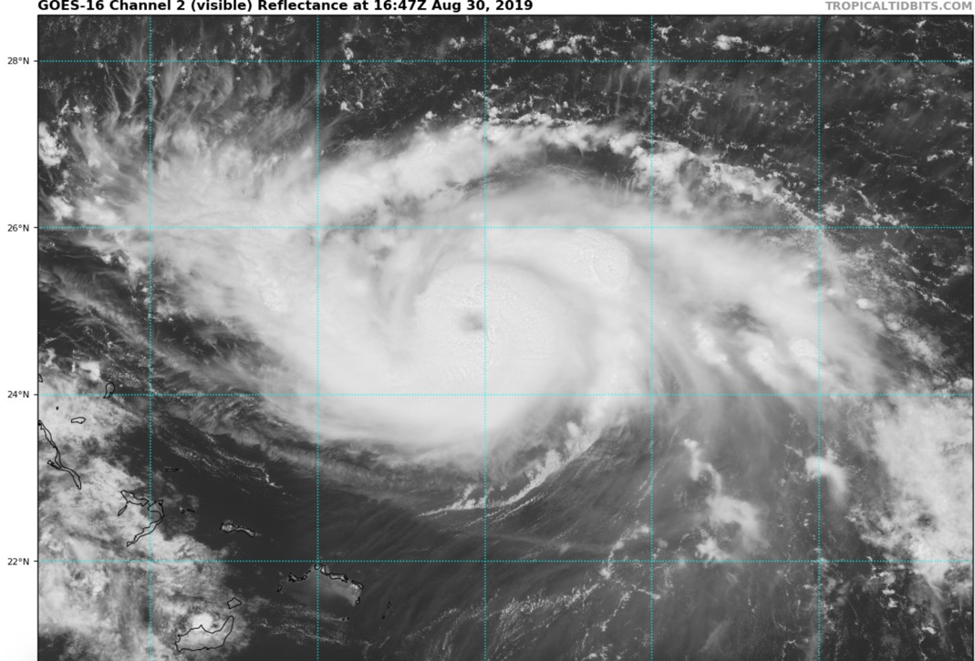
Dorian continues to strengthen this morning and has top winds of 110 mph now. The Air Force Reserve Hurricane Hunter plane found a flight level wind of 117 mh and surface winds of 108 mph. The central pressure was down to 972 millibars.
FAST FACTS AT 10 AM
———————————————–
LOCATION…24.5N 69.8W
ABOUT 480 MI…770 KM E OF THE NORTHWESTERN BAHAMAS
ABOUT 660 MI…1060 KM E OF WEST PALM BEACH FLORIDA
MAXIMUM SUSTAINED WINDS…110 MPH…175 KM/H
PRESENT MOVEMENT…NW OR 310 DEGREES AT 10 MPH…17 KM/H
MINIMUM CENTRAL PRESSURE…972 MB…28.71 INCHES
As you can see from the visible satellite imagery this morning, the eye is now evident.
The upper low that is southwest of Dorian is moving away and will become less of an impediment to intensification. It is likely that Dorian will be a category four hurricane before landfall, with top winds of 140 mph, or possibly more. There might be some slight weakening in the hours right before landfall as shown by some of the models, but Dorian will still be an extremely dangerous high-end category three or category four hurricane at landfall with the potential for tremendous storm surge, battering waves, flooding rains and destructive winds.
The current official NHC track carries it generally westward to a landfall north of West Palm Beach, then turns it sharply northward along the coast. This would bring widespread damage along much of the East Coast of Florida as the storm becomes a coastal runner.
Be alert to a more southerly and westerly track, which could put Fort Lauderdale and South Florida more in danger. We have seen it many times that a strengthening hurricane under a ridge will take a more westerly course. No one on the Florida Peninsula can let their guard down until we have a more certain idea of where Dorian will go.
There is some chance that it will get into the Gulf of Mexico, but the threat to the Florida Panhandle from Panama City to the west looks remote. The GFS ensemble mean does still have it running up the west coast of Florida to a second landfall over Apalachee Bay, near or east of Tallahassee.
About the Author (Author Profile)
Bill Murray is the President of The Weather Factory. He is the site's official weather historian and a weekend forecaster. He also anchors the site's severe weather coverage. Bill Murray is the proud holder of National Weather Association Digital Seal #0001 @wxhistorianSubscribe
If you enjoyed this article, subscribe to receive more just like it.


