Just After Midday: Even Though It’s A Hot One, It Is Bearable
It is a bright and beautiful day across Central Alabama as we have crossed over the midday and into the early afternoon. As of 1:45 pm, temperatures were in the mid-80s to the lower 90s across the area. Birmingham was at 88 degrees while the warm spot was 91 degrees in Montgomery. The cool spot was Gadsden at 84 degrees. Not much change for the rest of the daylight hours as we’ll continue to have sunny skies and highs topping out in the upper 80s to the lower 90s. Tonight for football games, no weather issues at all as we’ll have clear skies and temperatures in the upper 70s to the lower 80s at 7:00 pm and dropping into the lower to mid-70s by the final whistle. Overnight lows will drop into the 60s across the area.
Moisture levels will start to rise on Saturday and we’ll introduce a chance of a few isolated to scattered afternoon and early evening showers and thunderstorms for locations south of a line from Demopolis to Clanton to Roanoke. North of that, we’ll continue to have dry weather with mostly sunny skies. Highs will be in the lower 90s across the area.
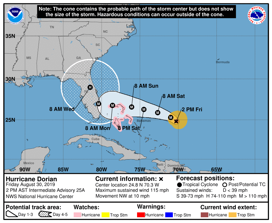
Hurricane Dorian Update
Dorian has become an extremely dangerous major hurricane and poses a significant threat to Florida and the northwestern parts of the Bahamas. Maximum sustained winds are now up 115 MPH making it a category 3 hurricane, along with a minimum central pressure of 970 MB. Key Messages:
1. Life-threatening storm surge and devastating hurricane-force winds are likely in portions of the northwestern Bahamas, where a hurricane watch is in effect. Residents should execute their hurricane plan and listen to the advice given by local emergency officials.
2. Life-threatening storm surge and devastating hurricane-force winds are likely along portions of the Florida east coast by early next week, but it is too soon to determine where the highest storm surge and winds will occur. Residents should have their hurricane plan in place, know if they are in a hurricane evacuation zone, and listen to the advice given by local emergency officials.
3. A prolonged period of storm surge, high winds and rainfall are likely in portions of Florida into next week, including the possibility of hurricane-force winds over inland portions of the Florida peninsula.
4. Heavy rains are expected over portions of the Bahamas, Florida, and elsewhere in the southeastern United States this weekend into the middle of next week.
Beach Forecast
Get the latest weather and rip current forecasts for the beaches from Fort Morgan to Panama City on our Beach Forecast Center page. There, you can select the forecast of the region that you are interested in.
WeatherReady Fest: A Free Preparedness & Safety Festival For The Entire Family
The National Weather Association Foundation is bringing WeatherReady Fest to the campus of the University of Alabama in Huntsville on September 7, 2019, from 10:00 am to 4:00 pm. This one-day festival will include family-friendly games, fun learning activities, large response vehicles, and enlightening speakers. Local and national celebrities will make special appearances, along with the NWA’s very own, Owlie Skywarn. Over 6,000 attendees showed up in St. Louis for last year’s event… let’s break that record this year. Get your free timed tickets now as they are going fast. More information and a link to tickets are available on the festival website at www.weatherreadyfest.com. Hope to see you there!
Category: Alabama's Weather, ALL POSTS, Tropical
About the Author (Author Profile)
Scott Martin is an operational meteorologist, professional graphic artist, musician, husband, and father. Not only is Scott a member of the National Weather Association, but he is also the Central Alabama Chapter of the NWA president. Scott is also the co-founder of Racecast Weather, which provides forecasts for many racing series across the USA. He also supplies forecasts for the BassMaster Elite Series events including the BassMaster Classic.Subscribe
If you enjoyed this article, subscribe to receive more just like it.


