Late Evening Update on Hurricane Dorian, Including State by State Impacts
By Meteorologists Johnny Parker and Bill Murray
Hurricane Dorian continues its slow movement just offshore of the Florida’s east coast this evening after bringing devastating impacts to portions of the Bahamas during the last few days. The name Dorian will likely be retired and never be used again.
Due to its very slow movement, the system churned the waters and weakened as a result of ocean upwelling which brings up cooler waters from greater depths. Without water temperatures in the 80 to 85 degree range, hurricanes cannot sustain their intensity.
This year’s Atlantic hurricane season has been pretty inactive up until a week ago. Meteorologists refer to the ACE (Accumulated Cyclone Energy) Index as a measurement of overall activity for individual storms as well as the total activity for a hurricane season. The 2019 hurricane season has been below the normal ACE index values, until Hurricane Dorian. Dorian’s rapid intensification and its 27 hours spent as a category 5 hurricane has really ramped up its accumulated energy value. This brought the current 2019 ACE Index up normal levels.
Few hurricanes, however, have moved as slowly as Hurricane Dorian (less than 10mph) with 185mph sustained winds. The only other category 5 hurricane of a similar nature was Hurricane Mitch in 1998 which caused devastation across Nicaragua and Central America.
Although Hurricane Dorian has weakened to a category 2 at this point, over the next few days, a re-intensification is possible as it hits the Gulf Stream waters. And remember, the category is only related to wind, not surge, rainfall, and tornadoes.
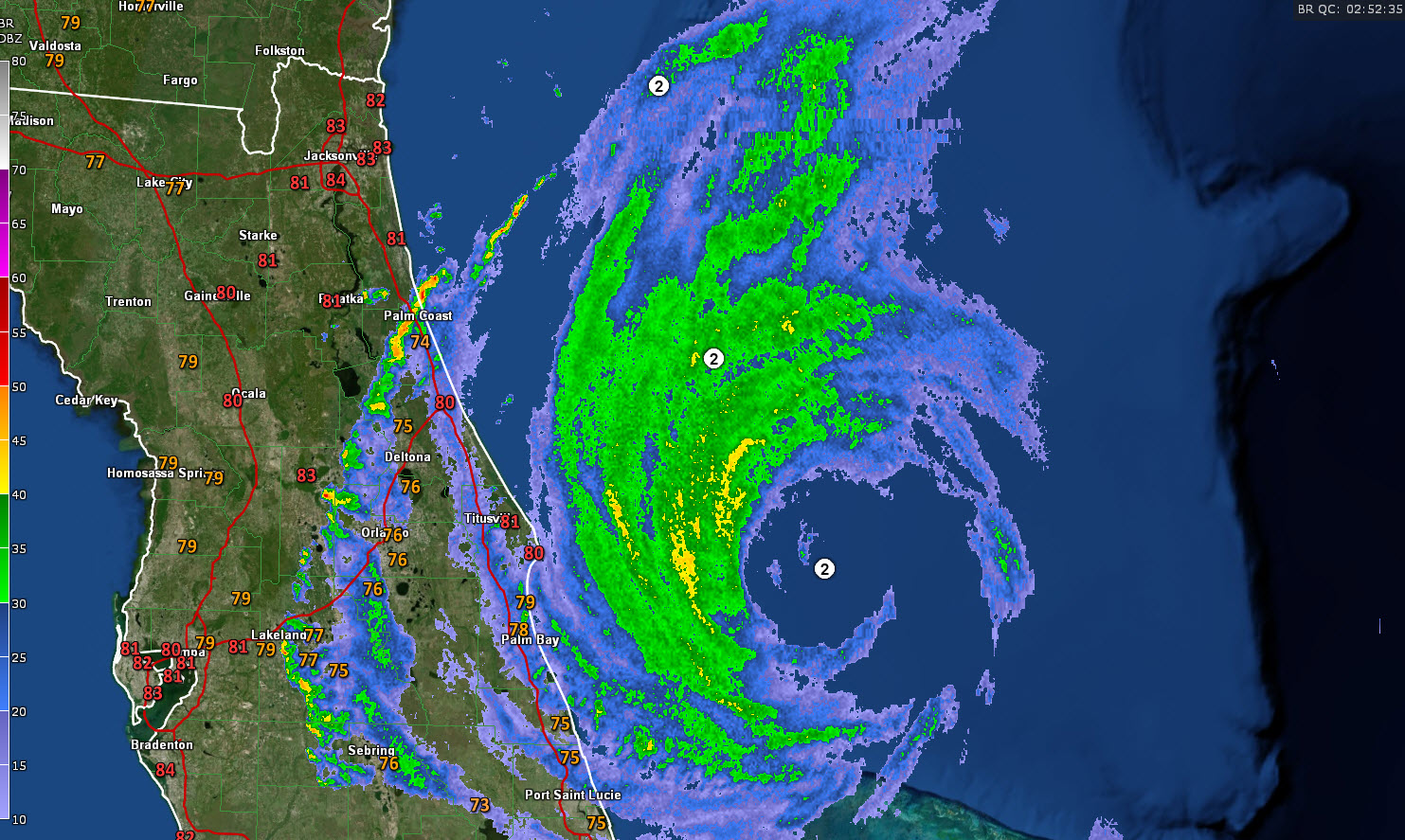
LATEST STATS
95 miles east of Cape Canaveral
Max sustained winds 110 mph (Category 2)
Central Pressure 959 mb
Movement: NNW-6
A wind gust to 47 mph was reported at New Smyrna Beach earlier
The NOAA buoy north of the eye just recorded a wind of 90 mph
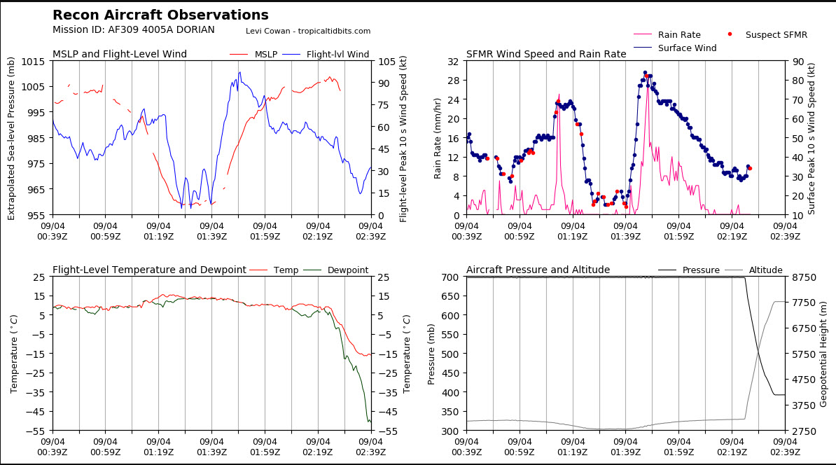
RECON
Latest report from the Air Force plan at 6:37 shows minimum pressure of 960 mb. Since that wasn’t exactly the center as the sonde splashed with 6 mph wind, the pressure of 958 sounds right. The eye is circular and down to a diameter of 22 miles. It is open to the east.
This plane is heading back to Biloxi now. A new plane just left for the storm and will be on station in a couple of hours.
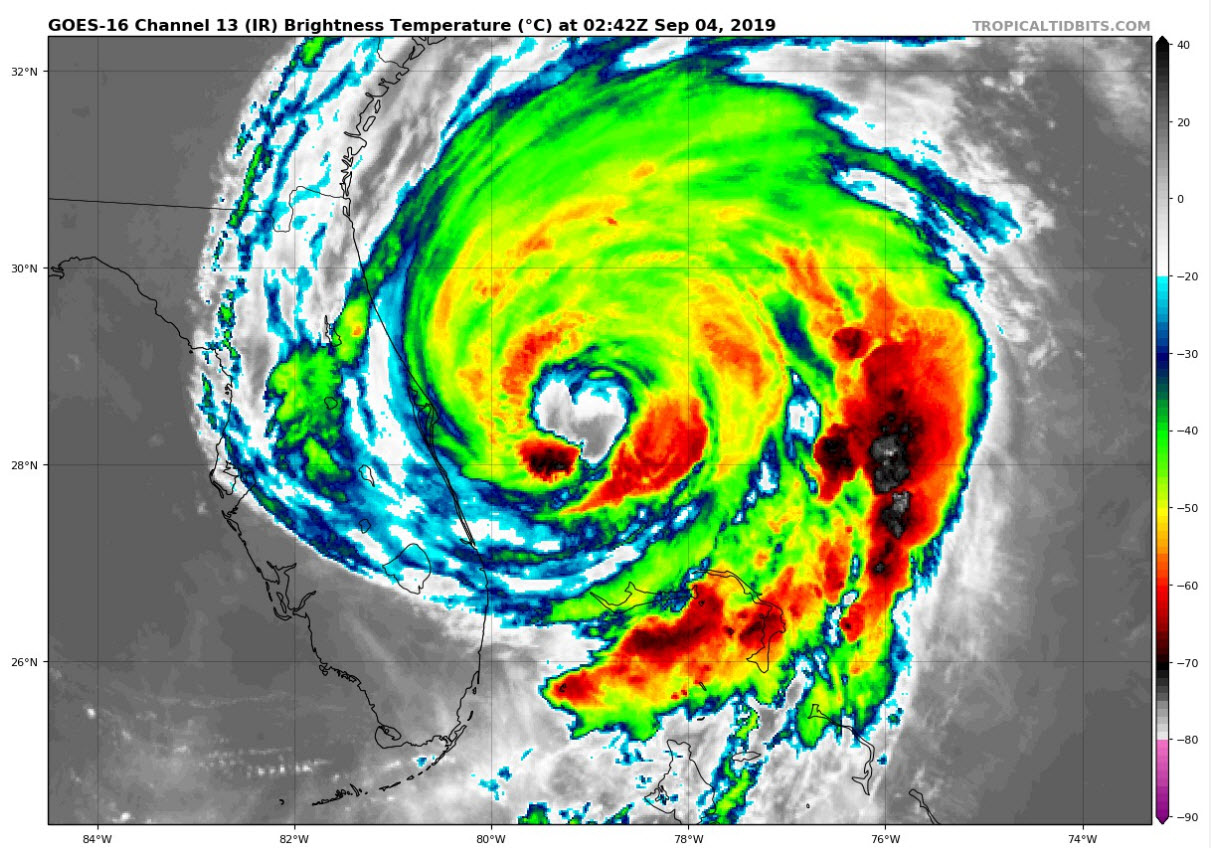
SATELLITE
There is a lot of dry air wrapping into the system, but the center is going over the Gulfstream and there have been bursts of convection wrapping around the eye. So the storm will probably hold this intensity at least, and could even strengthen a little over the next day or so.
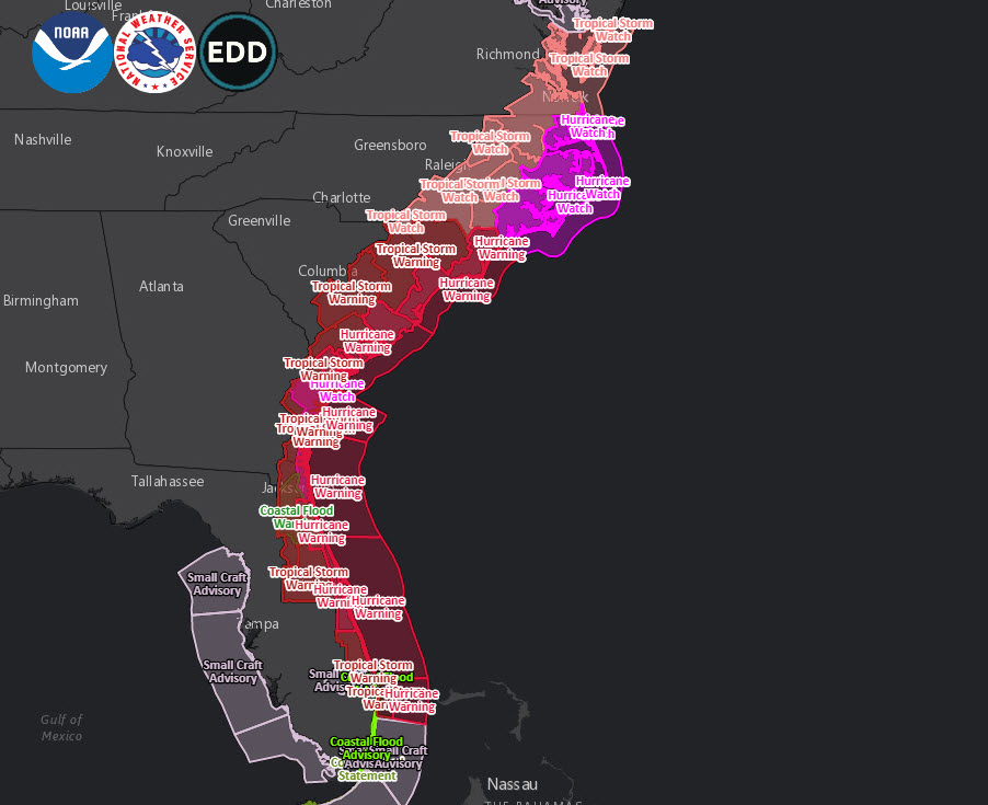
IMPACTS
SOUTH FLORIDA
Areas from Jupiter south are now pretty much in the clear. Areas along the coast from Stuart to Fort Pierce and Vero Beach will experience since of tropical storm force. Heavy rain in feeder bands wrapping around the circulation will cause some flooding and possible tornadoes in areas north of Fort Lauderdale. 3-6 feet of surge is still possible along the coast for areas north of Jupiter and 1-3 feet all the way back to Miami.
CENTRAL FLORIDA
In the hurricane warning area from Sebastian to Ponte Vedra, sustained tropical storm force winds will reach the coast this evening. There could be a period of strong tropical storm force winds, higher than 58 mph, later this evening for areas from Merritt Island through Cape Canaveral all the way to Palm Coast. As the hurricane continues to expand its circulation, these conditions will continue. Any shift to the left, however unlikely, could spread hurricane conditions closer to the coast. 4-8 inches of rain with isolated 10 inch amounts are possible along the Space and Treasure Coasts. Major beach erosion is occurring. Tornadoes are possible as well.
NORTHEAST FLORIDA
The center of Dorian should remain on a northward track about 75 mile east of the coast around Jacksonville. But there will still be substantial beach erosion. A storm surge of 3-5 feet is possible. Rains of 3-6 inches may cause flooding. The atmosphere is favorable for tornadoes.
GEORGIA
Tropical storm force winds will reach the coast of Georgia tomorrow morning. Winds could reach 45-44 mph with gusts to 70 mph Savannah. Strong tropical storm force winds of 58 mph or more could brush the coast and there is a small chance that hurricane conditions could affect the coast if the center is a little west of the track. Rainfall amounts should run 2-4 inches along the coast. There could be tornadoes in the feeder bands. Surge will potentially reach 3-5 feet along the coast.
SOUTH CAROLINA
On its forecast track, the center will pass about 40-50 miles off the South Carolina coast on Thursday, starting around midnight. The South Carolina coast is under a hurricane warning. Winds will reach 55-75 mph with gusts to 90 mph, including locations such as Charleston. As much as 6-8 inches of rain could fall near the coast. Flash flood watches are in effect. Storm surge could reach 3-5 feet along the coast. There is a fear that water levels in Charleston Harbor could approach levels recorded in Matthew.
NORTH CAROLINA
Hurricane warnings are in effect for coast around Wilmington, Wrightsville Beach, and Oak Island. Winds of 65-85 mph are expected with gusts to 100 mph. A hurricane watch is in effect for the remainder of the coast and Outer Banks. The center on its forecast track will pass very near Cape Fear Thursday night and over Cape Lookout and Hatteras Friday morning. 4-7 feet of storm surge may impact the coast around Wilmington and 3-5 feet across the Outer Banks. Rains could reach 6-10 inches with isolated amounts of over 20 inches.
MID-ATLANTIC
Tropical storm watches are in effect for southeastern Virginia and southern Maryland.
KEY TAKEAWAY
Don’t focus on the forecast track. It can shift 150 miles over the next 4 days. Impacts will occur well from the center. And categories only relate to winds, not the impacts of surge, heavy rain, and tornadoes.
HISTORIC IMPACT IN THE BAHAMAS
The video and photos out of the Bahamas is absolutely heart-breaking. Officials report the death toll is 8 now, but it will certainly be many, many times higher.
JOSH MORGERMAN
Veteran Hurricane Chaser Josh Morgerman sent some dramatic tweets today after his frightening experience. This says it all:
By far the most intense cyclone I’ve witnessed in 28 years of chasing. Thought I was playing it safe by riding it out in a solid-concrete school on a hill in Marsh Harbour. Thought wrong.
Winds pounded the building with the force of a thousand sledgehammers. Crept out during eye to find school mostly destroyed, cars in parking lot thrown around & mutilated. Barometer said 913.4 mb.
Frantically piled into few functioning cars (one of them mine) & relocated to government complex before backside struck. Building filled with terrorized refugees, many who had swam to safety or abandoned collapsed houses. The calm eye saved lives—gave victims chance to relocate.
Whole neighborhoods were swept by mighty surge higher than anything in memory. Areas above water had catastrophic wind damage. Many deaths reported from drowning, flying debris, & collapsing houses. Medical clinic overwhelmed. An absolute catastrophe. SEND HELP TO ABACO ISLANDS.
About the Author (Author Profile)
Bill Murray is the President of The Weather Factory. He is the site's official weather historian and a weekend forecaster. He also anchors the site's severe weather coverage. Bill Murray is the proud holder of National Weather Association Digital Seal #0001 @wxhistorianSubscribe
If you enjoyed this article, subscribe to receive more just like it.


