Dry Through The Weekend; Dorian Finally Moving
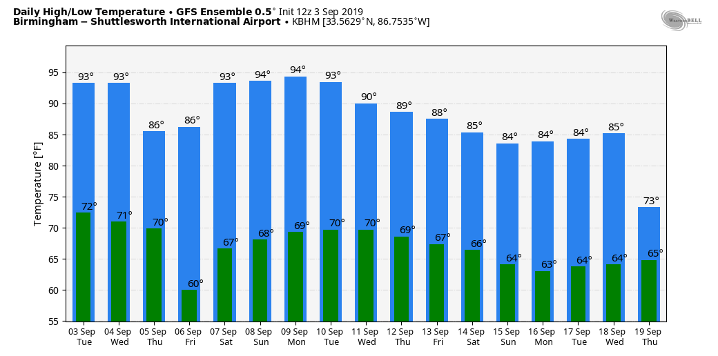
DRY THROUGH THE WEEKEND: A very dry airmass will cover Alabama over the next seven days, meaning little, if any chance of rain. We are forecasting sunny days and fair nights through Sunday. Highs will be in the mid 90s tomorrow, then closer to 90 Thursday and Friday following a dry front that will pass through here tomorrow night. Nights will be cooler later this week; many spots will enjoy a low in the 50s early Friday morning.
For the weekend, look for highs in the low 90s Saturday and Sunday with lows generally in the 60s. No, it won’t feel like fall. And, dry weather will continue through at least the first half of next week. See the Weather Xtreme video for maps, graphics, and more details.
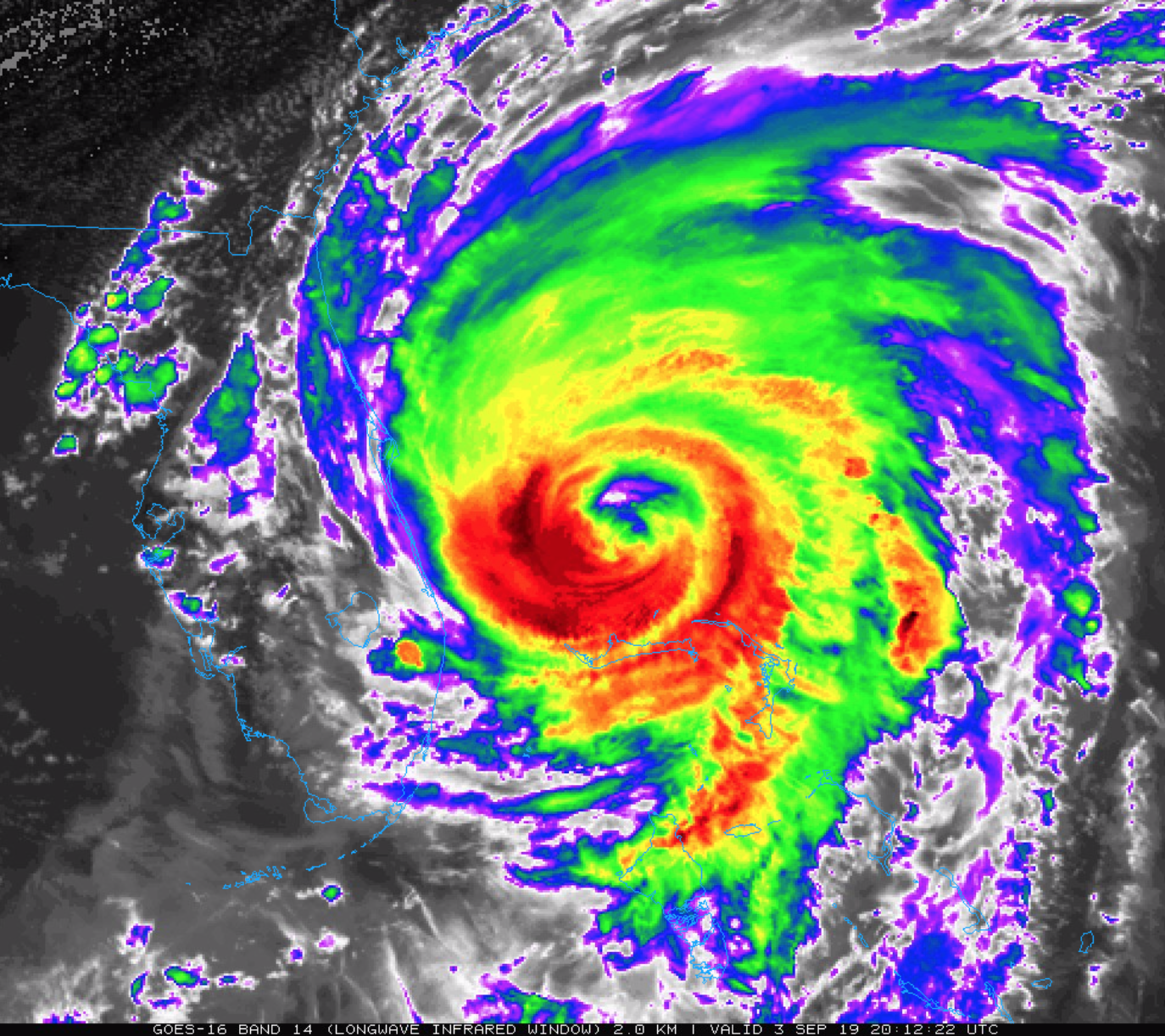
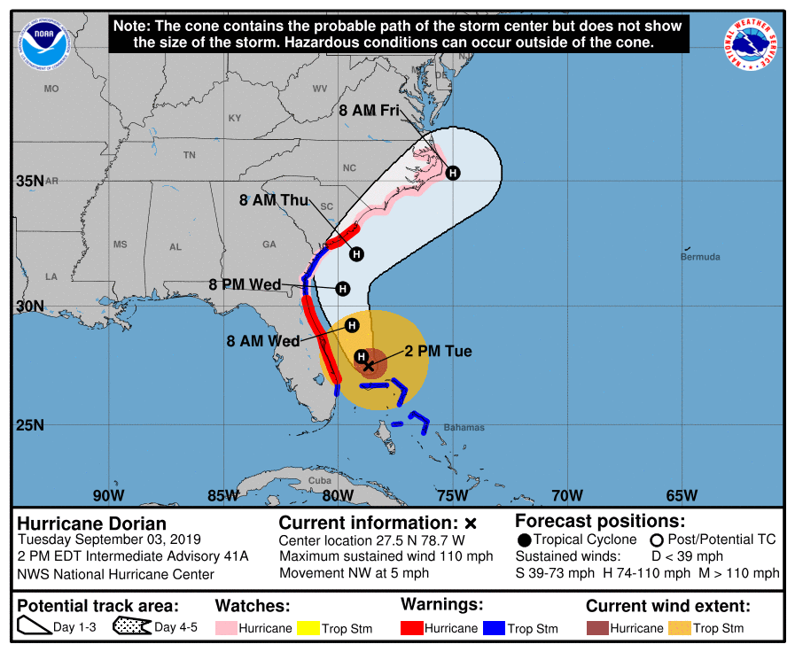
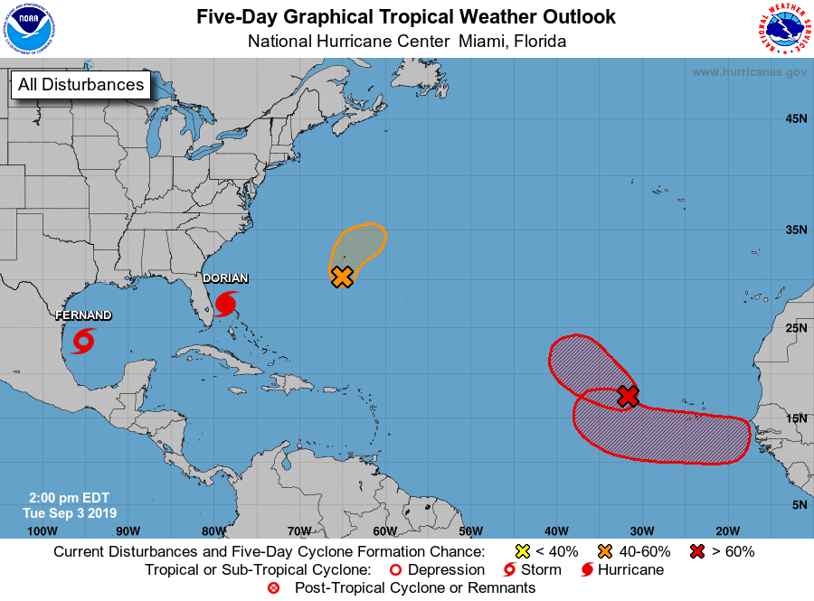
HURRICANE DORIAN: Dorian is now a category two hurricane with sustained winds of 110 mph.?? moving very slowly northward.?
Important points….
*As Dorian moves near the east coast of Florida during the next day or two, little overall change in intensity is anticipated. After that time, increasing shear should result in a gradual decrease in the peak wind speed while the hurricane gains latitude and grows in size.
*Although the official forecast does not show Dorian making landfall along the Florida east coast, the increasing size of Dorian’s wind field along with any deviation to the left of the forecast track will bring hurricane-force winds onshore along portions of the Florida east coast.
*Data from aircraft and buoys indicate that the hurricane is growing in size. Hurricane-force winds extend outward up to 60 miles from the center and tropical-storm-force winds extend outward up to 175 miles.Hurricane-force winds extend outward up to 60 miles from the center and tropical-storm-force winds extend outward up to 175 miles.Hurricane-force winds extend outward up to 60 miles from the center and tropical-storm-force winds extend outward up to 175 miles.
*A Hurricane Warning is in effect for…
Grand Bahama and the Abacos Islands in the northwestern Bahamas
Jupiter Inlet FL to Ponte Vedra Beach FL
North of Edisto Beach SC to South Santee River SC
*A Hurricane Watch is in effect for…
North of Ponte Vedra Beach FL to Edisto Beach SC
North of South Santee River SC to Duck NC
Albemarle and Pamlico Sounds
*Life-threatening storm surge and dangerous winds are expected along portions of the Florida east coast and the coasts of Georgia and South Carolina, regardless of the exact track of Dorian’s center. Water levels could begin to rise well in advance of the arrival of strong winds. Residents in these areas should follow advice given by local emergency officials.
*The risk of life-threatening storm surge and hurricane-force winds continues to increase along the coast of North Carolina. Residents in these areas should follow advice given by local emergency officials.
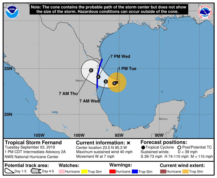
TROPICAL STORM FERNAND: A new tropical storm has formed in the western Gulf of Mexico; it will move into the coast of northern Mexico tomorrow night, south of Brownsville, Texas. No impact on Alabama or the Central Gulf Coast.
REST OF THE ATLANTIC BASIN: NHC is monitoring three other areas over the tropical Atlantic; two of them will move into the North Atlantic and are no threat to the U.S. One, coming off the coast of Africa, will move west, and it remains to be seen if it will recurve, or be a threat to the Lesser Antilles or points west.
ON THIS DATE IN 1979: Hurricane David made landfall in South Florida as a Category 2 storm. It caused 15 deaths in the US. Hurricane David was a Category 5 over the Dominican Republic were over 2,000 people died.
BEACH FORECAST: Click here to see the AlabamaWx Beach Forecast Center page.
WEATHER BRAINS: Don’t forget you can listen to our weekly 90 minute show anytime on your favorite podcast app. This is the show all about weather featuring many familiar voices, including our meteorologists here at ABC 33/40.
CONNECT: You can find me on all of the major social networks…
Facebook
Twitter
Instagram
Pinterest
Snapchat: spannwx
Look for the next Weather Xtreme video here by 7:00 a.m. tomorrow…
Category: Alabama's Weather, ALL POSTS, Weather Xtreme Videos
About the Author (Author Profile)
James Spann is one of the most recognized and trusted television meteorologists in the industry. He holds the AMS CCM designation and television seals from the AMS and NWA. He is a past winner of the Broadcast Meteorologist of the Year from both professional organizations.Subscribe
If you enjoyed this article, subscribe to receive more just like it.


