Dry Through The Weekend In Alabama; Dorian Far To The East
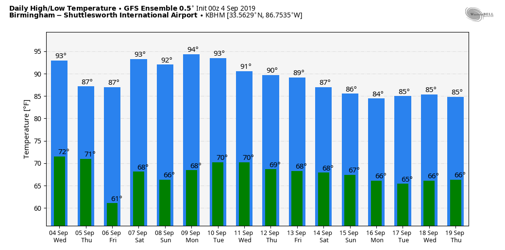
DRY SEPTEMBER WEATHER: Dry weather will continue across Alabama through the weekend. We rise into the mid 90s today; the average high for September 4 in Birmingham is 89. A surface front will pass through the state tonight in dry fashion, and will prolong the rain-free weather through the weekend. The high tomorrow will be close to 90, and cooler spots drop into the 50s early Friday morning.
For the weekend, look for sunny days with highs in the low to mid 90s Saturday and Sunday.
NEXT WEEK: Dry weather continues Monday, but global models suggest moisture levels will rise with a chance of scattered showers Tuesday, and we will mention some risk of showers each day for the rest of the week. Nothing too widespread, but at least some neighborhoods could see some needed rain. See the Weather Xtreme video for maps, graphics, and more details.
FOOTBALL WEATHER: For the high school games Friday night, the sky will be clear with temperatures falling from the upper 80s at kickoff, into the upper 70s by the final whistle.
Saturday, Alabama hosts New Mexico State at Bryant-Denny Stadium in Tuscaloosa (3p CT kickoff)… it will be a sizzling afternoon with a kickoff temperature near 97 degrees, falling into the low 90s by the fourth quarter. The sky will be mostly sunny.
Auburn will host Tulane Saturday evening (6:30p CT kickoff)… the sky will be clear with temperatures falling from 90 degrees at kickoff into the upper 70s by the final whistle.
UAB is on the road… they travel to Akron, Ohio to play the Zips Saturday (11a CT kickoff). The sky will be mostly sunny with temperatures rising from the low 70s at kickoff, into the mid 70s by the fourth quarter.
HURRICANE DORIAN: Dorian is moving north/northwest, off the east coast of Florida, with sustained winds of 105 mph (category two).

Important points….
*The official NHC forecast maintains the current intensity for a day or so and then shows a very slow weakening thereafter. The system is expected to maintain close to category 2 strength until it passes near or over the North Carolina Outer Banks.
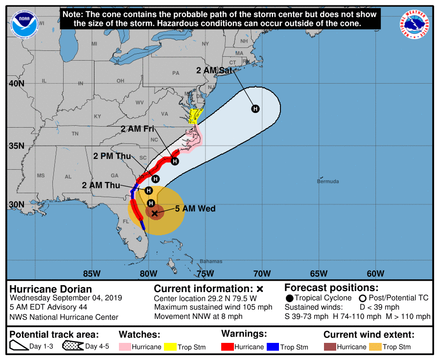
*Hurricane-force winds extend outward up to 60 miles from the center, and tropical-storm-force winds extend outward up to 175 miles.
*A Hurricane Warning is in effect for…
Volusia/Brevard County FL line to Ponte Vedra Beach FL
North of Savannah River to Surf City NC
*A Hurricane Watch is in effect for…
North of Ponte Vedra Beach FL to Savannah River
North of Surf City NC to the North Carolina/Virginia border
Albemarle and Pamlico Sounds
*Life-threatening storm surge and dangerous winds are expected along portions of the Florida east coast and the coasts of Georgia, South Carolina, and North Carolina, regardless of the exact track of Dorian’s center. Water levels could rise well in advance of the arrival of strong winds. Residents in these areas should follow advice given by local emergency officials.
*The risk of wind and rain impacts along portions of the Virginia coast and the southern Chesapeake Bay are increasing. Residents in these areas should continue to monitor the progress of Dorian.
*The flash flood threat will spread up the southeast U.S. coast today and Thursday, then across the coastal Mid-Atlantic region on Friday. There is a high risk of flash flooding on Thursday across coastal sections from northeast South Carolina into southern North Carolina.
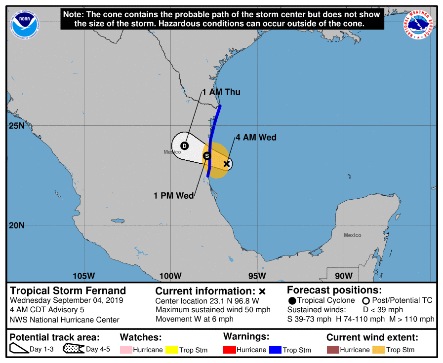
TROPICAL STORM FERNAND: The system in the far western Gulf of Mexico will move into the coast of northern Mexico today, then dissipating inland by Friday. This will bring some needed rain to the lower Rio Grande valley region of Texas.
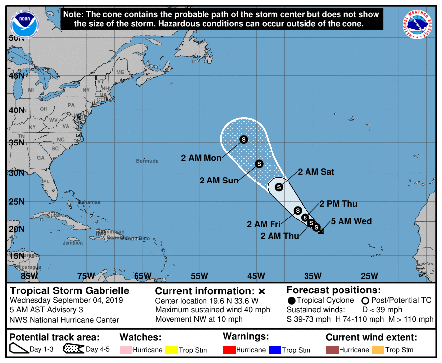
TROPICAL STORM GABRIELLE: A new tropical storm is in the eastern Atlantic; it will gain latitude and most likely will be no threat to land.
ELSEWHERE IN THE TROPICS: A disturbance south of Bermuda could become a tropical depression later today, but it will move north/northeast and is no threat to the U.S. A new tropical wave will emerge off the coast of Africa by Friday; this could develop as it moves westward. Too early to know if it comes toward the Lesser Antilles, or recurves into the open Atlantic.
ON THIS DATE IN 2011: The center of Tropical Storm Lee moved ashore around sunrise. However, it would be a while before Lee would weaken to a depression as it remained nearly stationary while the southern half of the circulation was over water where it could continue to derive additional energy from the warm ocean. Lee brought torrential rains to Louisiana, Mississippi, and Alabama.
BEACH FORECAST: Click here to see the AlabamaWx Beach Forecast Center page.
WEATHER BRAINS: Don’t forget you can listen to our weekly 90 minute show anytime on your favorite podcast app. This is the show all about weather featuring many familiar voices, including our meteorologists here at ABC 33/40.
CONNECT: You can find me on all of the major social networks…
Facebook
Twitter
Instagram
Pinterest
Snapchat: spannwx
I have a weather program this morning at Clanton Middle School… look for the next Weather Xtreme video here by 4:00 this afternoon. Enjoy the day!
Category: Alabama's Weather, ALL POSTS, Weather Xtreme Videos
About the Author (Author Profile)
James Spann is one of the most recognized and trusted television meteorologists in the industry. He holds the AMS CCM designation and television seals from the AMS and NWA. He is a past winner of the Broadcast Meteorologist of the Year from both professional organizations.Subscribe
If you enjoyed this article, subscribe to receive more just like it.


