Hurricane Dorian Looking Better Organized This Morning; Making the Advertised Turn But Will Scrape Coastal Carolinas
By Meteorologist Johnny Parker and Bill Murray
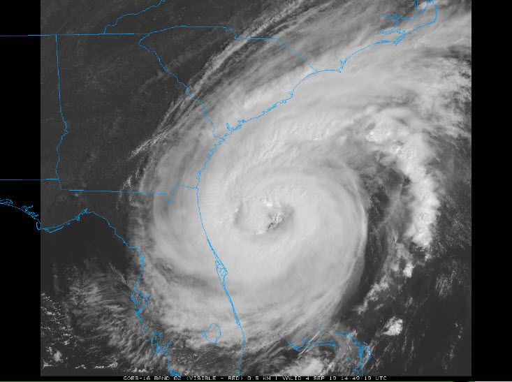
On Wednesday morning Hurricane Dorian continued its slow march along the east coast of Florida. Dorian is located approximately 135 miles to the East-Southeast of Jacksonville, Florida. It is currently moving North-Northwest at 9 mph. Top winds are down to 105mph with a 964mb pressure. However, with a maximum sustained wind speed of 105 mph, the coastlines of Florida, Georgia and the Carolinas are bracing for significant storm surge, flooding, and damaging winds.
The storm path is expected to track closer to land later today and into Thursday, putting the Carolinas at risk for landfall, particularly in North Carolina’s Outer Banks region. Landfall is now quite possible between Charleston and Morehead City late Thursday. Max winds should be around 100 mph, but these latest indications of organization are a little concerning. The storm does run into increasing shear the further north it goes so that hopefully will negate the strengthening trend. Stay tuned.
The Governor of North Carolina has ordered a mandatory evacuation of barrier islands as Dorian approaches.
Radar this morning shows that Dorian has a solid but bigger eye. The eye has increased to just over 65 miles in diameter. The rainbands continue to affect the east coast of Florida with gusty winds. A new recon aircraft is currently en route to investigate the storm. It just is arriving at the center after a pass in from the northwest. They found top flight-level winds of 93 mph and peak observed surface winds were 84 mph. The plane still has to investigate the other three quadrants, including the northeast quadrant where the strongest winds typically are found.
There has been a large increase in convection wrapping around the center. The environment is favorable for strengthening but is should be gradual, not rapid. We will be watching those reconnaissance reports carefully.
Tropical Storm Warnings extend from just south of Palm Bay, FL up to just north of Wilmington, NC with Hurricane Watches extending up to the Outer Banks of North Carolina to the southern Virginia coast. A Tropical Storm Watch extends from Virginia Beach up into southern Delaware.
The tropical-storm-force winds with Dorian extend out to 175 miles from the center and the hurricane-force winds extend out to 60 miles from the center. This large wind field will bring massive amounts of water toward the shore and will dump excessive rainfall. Storm surge values could reach 4-7 feet along much of the coast of South and North Carolina, with 5-8 foot tide in that concave porton of the coastline south of Cape Fear, including the Grand Strand and Myrtle Beach.
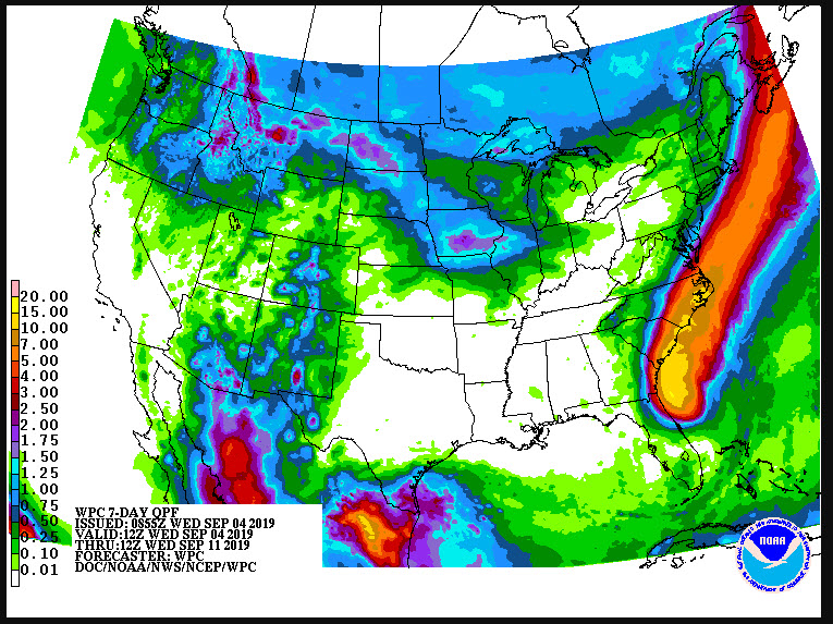
The heaviest rainfall from Dorian will be in the coastal Carolinas where 5 to 10 inches with locally up to 15 inches are expected. A general amount of 3 to 6 inches with locally 9 inches are expected from Daytona Beach, FL to the Georgia/South Carolina border and into Southeast Virginia.
About the Author (Author Profile)
Bill Murray is the President of The Weather Factory. He is the site's official weather historian and a weekend forecaster. He also anchors the site's severe weather coverage. Bill Murray is the proud holder of National Weather Association Digital Seal #0001 @wxhistorianSubscribe
If you enjoyed this article, subscribe to receive more just like it.


