Stay Tuned: Hurricane Dorian Appears to Be Strengthening; Could be Category Three Status Soon
By Meteorologists Johnny Parker and Bill Murray
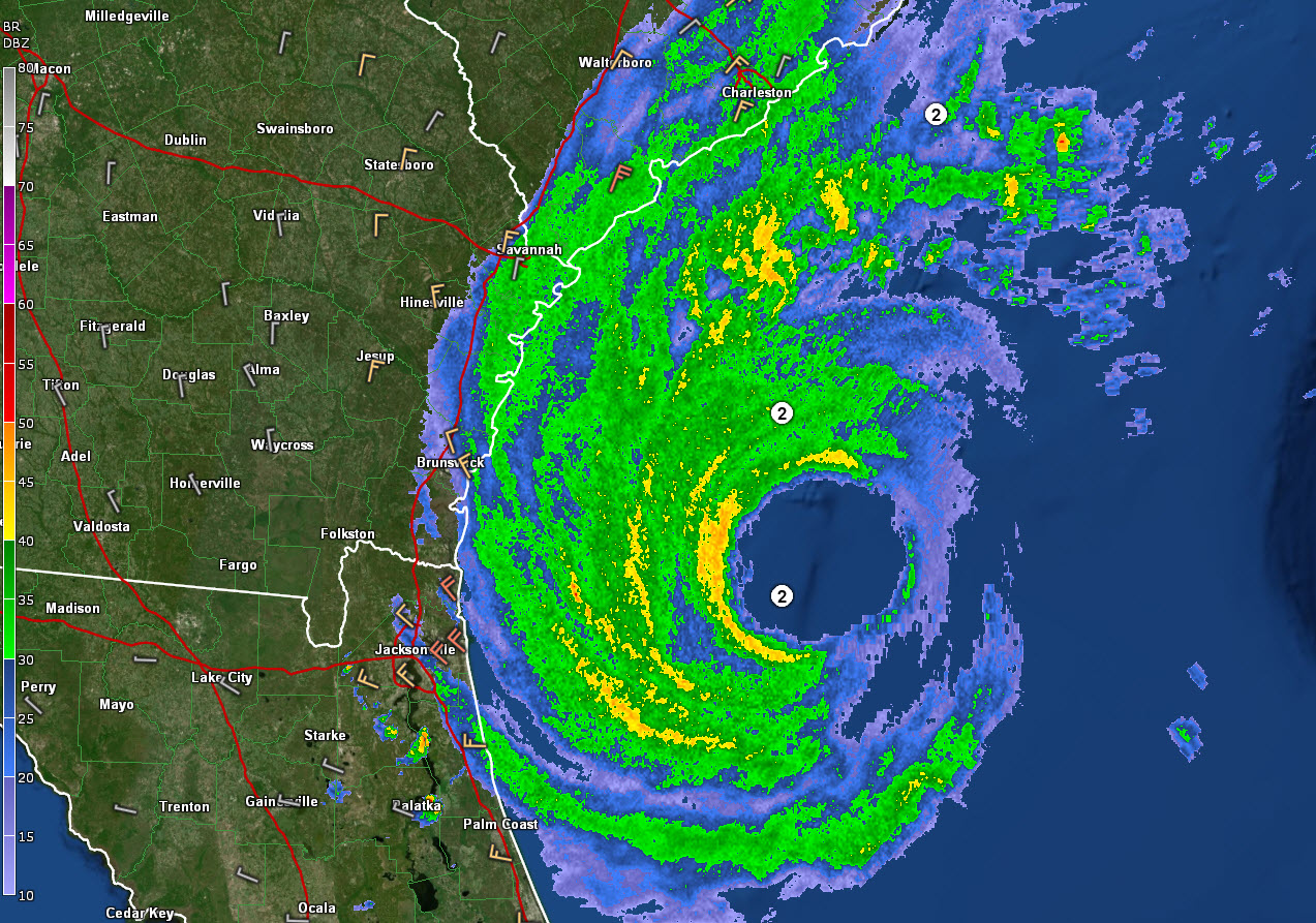
As Hurricane Dorian moves along the northern Florida and southeast Georgia coastline, its eye has tightened and has become more well defined, which indicates that it is strengthening. The maximum wind speeds have increased up to 110mph. The storm’s central pressure has decreased to 959mbars and movement continues north-northwest at 8mph.
The NOAA recon plane just estimated a surface wind of 114 mph in the southwestern eyewall. The plane did not attempt the penetration of the eye. Could it be because the convection was too strong for them to risk it? It certainly looks like the convection is impressive on that side according to infrared satellite imagery.
Dorian is now located 130 miles south of Charleston, South Carolina and approximately 255 miles south/southwest of Wilmington, North Carolina.
All Southeastern coastal regions will be impacted by strong winds. Some regions of Southeastern Georgia and South Carolina will experience their strongest winds during the overnight hours. Wind Advisories have been issued for non-coastal counties in Georgia, including the cities of Swainsboro and Vidalia. Gusts up to 35 mph or stronger are expected.
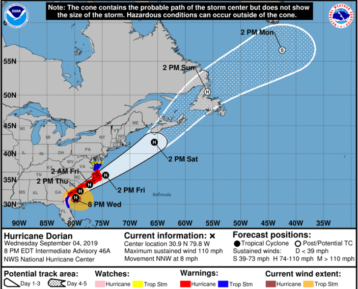
Here is the latest forecast track:
Dorian is only 1 mph below category 3 status right now. A cold front currently located in the Shenandoah region of West Virginia is expected to pass through the Carolinas tonight into tomorrow. This front will help shift Dorian eastward and should also increase its forward momentum. This could help it to pass more quickly out of the U.S. coastal regions.
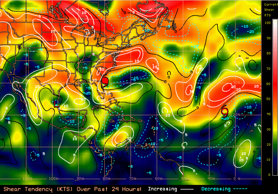
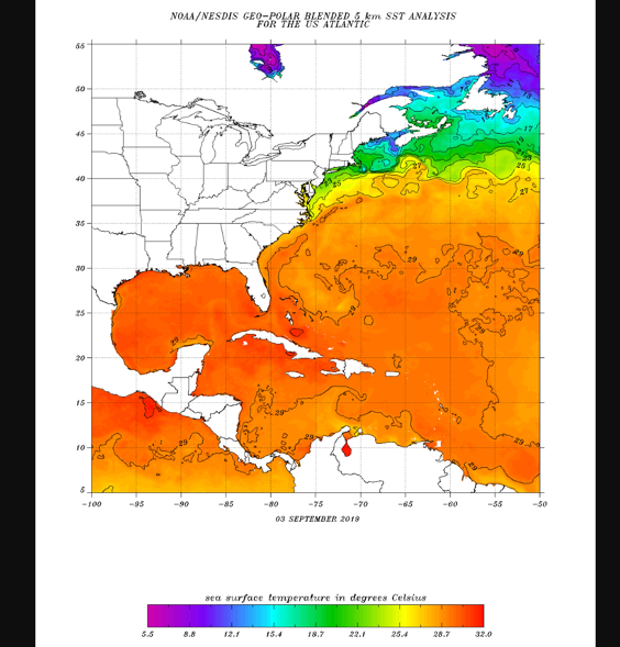
In its current location, Dorian is in a favorable environment for strengthening. There is less than 10 kts of wind shear impacting Dorian at this point and the temperatures in the Gulf Stream are very supportive for intensification. Its outer bands are relatively broad, as the system has increased in size.
The warmer waters have allowed thunderstorms to wrap around the system and it looks much more organized now on radar.
Coastal Observations:
Buoy 5E at St, Mary’s GA – reporting 12 foot waves with swells of 7 feet
Saint Simons, GA – Light rain falling, Winds at 21 mph sustained with 37 mph gusts and a rising pressure of 29.36 mb
Savannah, GA – Airport reporting 22 mph sustained winds with gusts at 33 mph, falling pressure of 29.72
Johns Island, SC – rain is falling and winds are sustained at 18 mph with gusts up to 29 mph, steady pressure readings at 29.76
Waterfront Park, SC- winds sustained at 23 mph, gusting to 30 mph, pressure holding at 29.61
About the Author (Author Profile)
Bill Murray is the President of The Weather Factory. He is the site's official weather historian and a weekend forecaster. He also anchors the site's severe weather coverage. Bill Murray is the proud holder of National Weather Association Digital Seal #0001 @wxhistorianSubscribe
If you enjoyed this article, subscribe to receive more just like it.


