Dorian’s Eyewall Grazing Cape Fear in North Carolina: Here are Expected Impacts Tonight and Tomorrow Morning
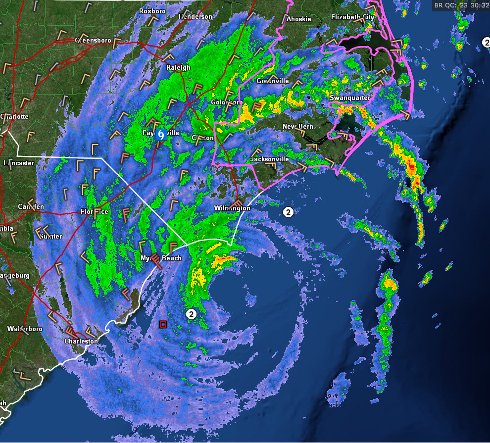
Hurricane Dorian’s eyewall is grazing the coast at Cape Fear in North Carolina right now. Myrtle Beach AFN is recording wind gusts to me 55 mph right now. Wilmington NC is picking up 43 mph gusts.
Dorian’s top winds are now 105 mph. The central pressure is 964 millibars.
So Dorian may not make the top ten of North Carolina hurricanes at landfall, but it will still pack a wallop. Here are some of the impacts:
WIND:
Hurricane warnings remain in effect along the coastal areas of South and North Carolina. Just inland, tropical storm warnings are in effect.
…MYRTLE BEACH SC…
Winds still gusting as high as 54 mph. They should begin diminishing soon and go below tropical storm force by 9 p.m.
…WILMINGTON NC…
Winds are gusting to between 26-32 mph right now. They will increase rapidly in the next few hours reaching strong tropical storm force early this evening. Hurricane-force winds will occur in gusts between 9 p.m. and 3 a.m. Peak gusts should be around 85 mph. Winds should go below tropical storm force shortly after sunrise.
…BEAUFORT NC…
Winds have been gusting to tropical storm force since 4:30 p.m. EDT, with a peak gust so far of 43 mph. Strong tropical-storm-force winds of 60 mph and higher will begin there around 10 p.m EDT and hurricane-force winds will arrive by 1 a.m. Hurricane-force gusts will end around sunrise with tropical-storm-force winds dinishing by noon. Peak gusts overnight should be around 95 mph.
…HATTERAS NC…
Winds have been gusting to 32mph at Hatteras on the North Carolina Outer Banks. Tropical-storm-force winds of 39 mph or higher will begin around 9 p.m. EDT with strong tropical-storm-force winds by 3 a.m. Hurricane-force winds will begin around sunrise. The eye should cross between 9-noon. Peak wind gusts should be around 95 mph.
STORM SURGE:
Storm surge at high tide will run 4-7 feet above dry ground from near the border of South and North Carolina through the OUter Banks, with 2-4 feet across the Hampton Roads area of southeastern Virginia.
…The storm surge at Wilmington is 4 feet above normal now and increasing. Winds will start shifting to offshore by midnight, but tides could reach 7 feet above normal before then. That’s good news because the next high tide is just after 3 a.m.
FLOODING
Rainfall has been heavy across South and North Carolina. Flash flood watches remain in effect.
Nerrs Meteorological Site in Georgetown County NC…11.29″
Socastee NC…10.61″
Castle Hayne, NC…10.25″
McClellanville SC…10.19″
Conway, SC…9.67″
North Myrtle Beach, SC…7.84′
Wilmington, NC…5.74″
Charleston, SC…5.12″
TORNADOES
There have been several reported tornadoes, including some impressive ones today across South Carolina and eastern North Carolina. A tornado watch remains in effect until 7 a.m. EDT for eastern North Carolina and southeastern Virginia.
LANDFALL
It appears that the landfall of the eye will occur around 5-6 a.m. EDT at Cape Lookout near Beaufort, NC.
LATE REPORTS
…Duke Energy reports both nuclear reactors at the Brunswick plant have been shut down in anticipation of Hurricane Force winds.
About the Author (Author Profile)
Bill Murray is the President of The Weather Factory. He is the site's official weather historian and a weekend forecaster. He also anchors the site's severe weather coverage. Bill Murray is the proud holder of National Weather Association Digital Seal #0001 @wxhistorianSubscribe
If you enjoyed this article, subscribe to receive more just like it.


