Dry Weekend Ahead With Hot Afternoons
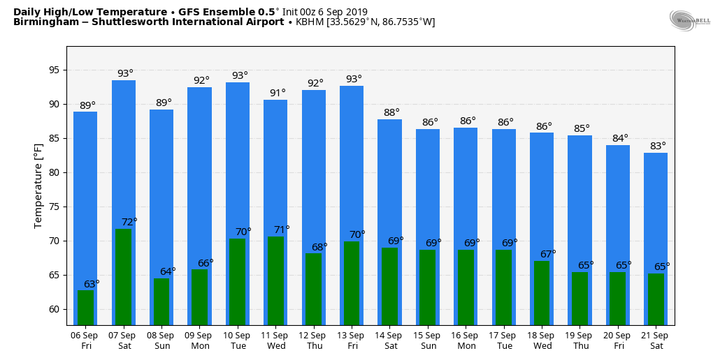
PLEASANT START: We have a cool early September morning across Alabama; cooler spots like Fort Payne and Cullman are in the upper 50s just before daybreak. But, we warm up in a hurry with sunshine in full supply today as we project a high in the low 90s this afternoon. Humidity levels will remain fairly low.
Not much change over the weekend… we are forecasting sunny, hot afternoons and fair pleasant nights. High in the mid 90s for most places tomorrow and Sunday.
NEXT WEEK: Prospects of beneficial rain don’t look good, but we could see a few widely scattered showers by mid-week. Otherwise, partly to mostly sunny days with highs generally in the low 90s. See the Weather Xtreme video for maps, graphics, and more details.
FOOTBALL WEATHER: For the high school games tonight, the sky will be clear with temperatures falling from the mid 80s at kickoff, into the upper 70s by the final whistle.
Tomorrow, Alabama hosts New Mexico State at Bryant-Denny Stadium in Tuscaloosa (3p CT kickoff)… it will be a sizzling afternoon with a kickoff temperature near 97 degrees, falling into the low 90s by the fourth quarter. The sky will be mostly sunny.
Auburn will host Tulane tomorrow evening (6:30p CT kickoff)… the sky will be clear with temperatures falling from 90 degrees at kickoff into the upper 70s by the final whistle.
UAB is on the road… they travel to Akron, Ohio to play the Zips tomorrow (11a CT kickoff). The sky will be mostly sunny with temperatures rising from near 70 at kickoff, into the mid 70s by the fourth quarter.
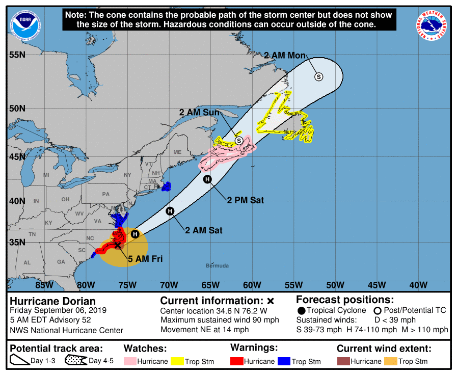
HURRICANE DORIAN: Sustained winds are down to 90 mph; the eye is just east of Cape Lookout and the North Carolina Outer Banks early this morning.

Dorian is moving northeast at 14 mph; life-threatening storm surge and dangerous winds are expected to continue today along portions of the North Carolina coast, portions of southeast Virginia and the southern Chesapeake Bay. Water levels could rise well in advance of the arrival of strong winds. Residents in these areas should follow advice given by local emergency officials.
The hurricane heads for the Canadian Maritimes over the weekend as a post-tropical system.
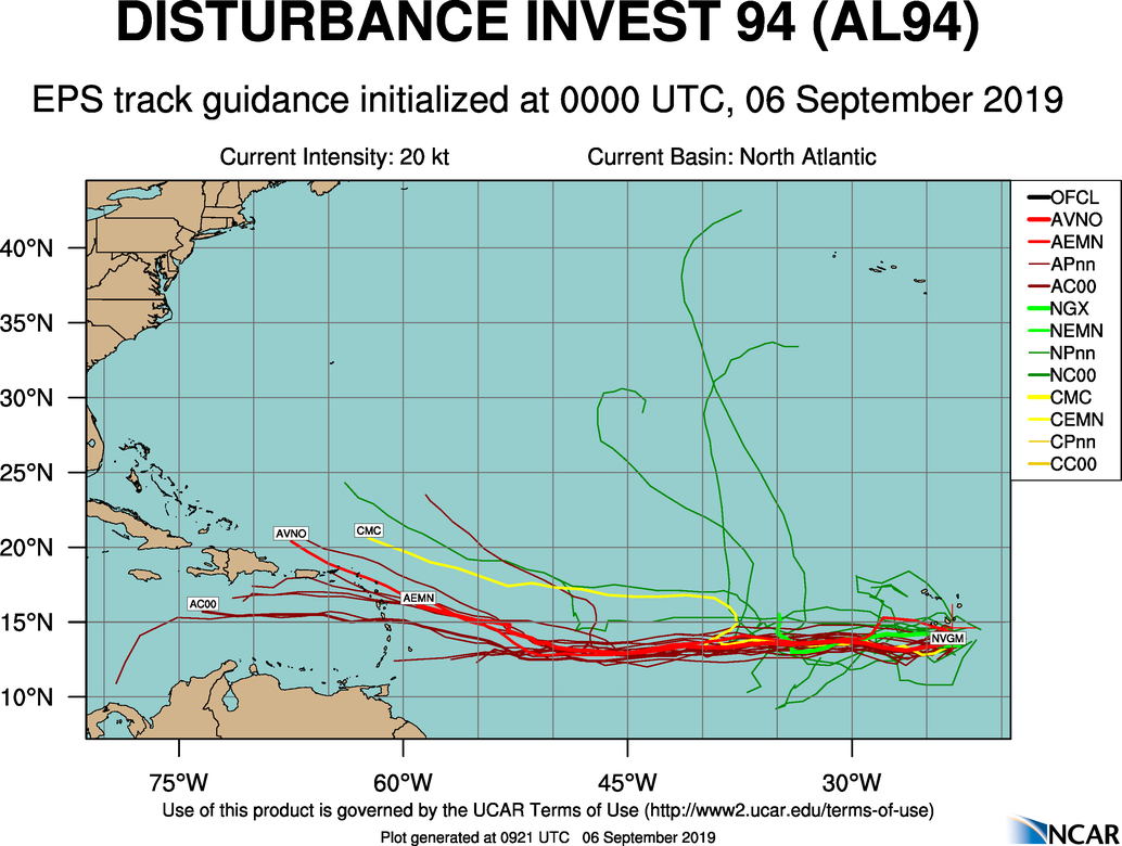
ELSEWHERE IN THE TROPICS: Tropical Storm Gabrielle has become post-tropical over the middle of the Atlantic. Waves east of the Leeward Islands, and northeast of Bermuda are given only a low chance of development. The one to watch is Invest 94L, which is in the far eastern Atlantic. This looks like a low latitude system, and global models suggest this is headed in the direction of the Lesser Antilles in five days or so. Too early to know if this will threaten the Gulf of Mexico or the U.S.
ON THIS DATE IN 2017: Category 5 Hurricane Irma affected the US Virgin Island and Puerto Rico. Maximum sustained winds were at 180 mph when the storm hit St. Thomas & St. John. Catastrophic damage was reported over the US Virgin Island & significant damage over Puerto Rico, especially over Culebra.
BEACH FORECAST: Click here to see the AlabamaWx Beach Forecast Center page.
WEATHER BRAINS: Don’t forget you can listen to our weekly 90 minute show anytime on your favorite podcast app. This is the show all about weather featuring many familiar voices, including our meteorologists here at ABC 33/40.
CONNECT: You can find me on all of the major social networks…
Facebook
Twitter
Instagram
Pinterest
Snapchat: spannwx
I have a weather program this morning at Englewood Elementary in Tuscaloosa… look for the next Weather Xtreme video here by 4:00 this afternoon. Enjoy the day!
Category: Alabama's Weather, ALL POSTS, Weather Xtreme Videos
About the Author (Author Profile)
James Spann is one of the most recognized and trusted television meteorologists in the industry. He holds the AMS CCM designation and television seals from the AMS and NWA. He is a past winner of the Broadcast Meteorologist of the Year from both professional organizations.Subscribe
If you enjoyed this article, subscribe to receive more just like it.


