7:00 AM Advisory Is Out On Tropical Storm Humberto
BULLETIN
Tropical Storm Humberto Intermediate Advisory Number 7A
NWS National Hurricane Center Miami FL AL092019
800 AM EDT Sat Sep 14 2019
…CENTER OF HUMBERTO PASSING JUST EAST OF GREAT ABACO ISLAND…
…MOST THE HEAVY SQUALLS ARE OCCURING NORTH AND EAST OF THE CENTER…
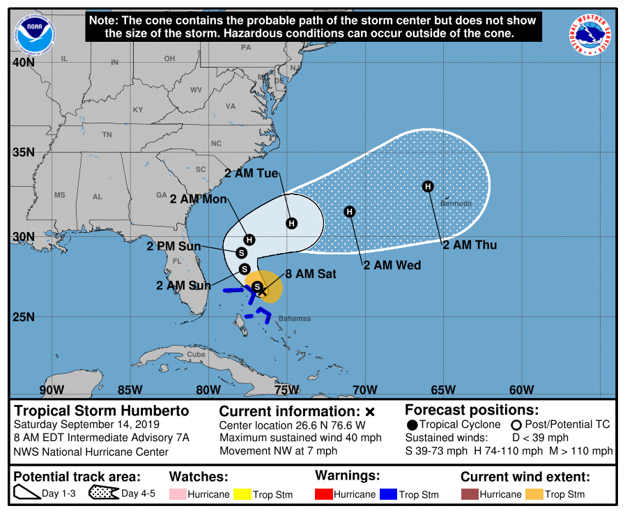
SUMMARY OF 800 AM EDT…1200 UTC…INFORMATION
LOCATION…26.6N 76.6W
ABOUT 30 MI…45 KM ENE OF GREAT ABACO ISLAND
ABOUT 145 MI…235 KM E OF FREEPORT GRAND BAHAMA ISLAND
MAXIMUM SUSTAINED WINDS…40 MPH…65 KM/H
PRESENT MOVEMENT…NW OR 315 DEGREES AT 7 MPH…11 KM/H
MINIMUM CENTRAL PRESSURE…1004 MB…29.65 INCHES
WATCHES AND WARNINGS
SUMMARY OF WATCHES AND WARNINGS IN EFFECT:
A Tropical Storm Warning is in effect for…
* Northwestern Bahamas excluding Andros Island
A Tropical Storm Warning means that tropical storm conditions are expected somewhere within the warning area.
For storm information specific to your area, please monitor products issued by your national meteorological service.
DISCUSSION AND OUTLOOK
At 800 AM EDT (1200 UTC), the center of Tropical Storm Humberto was located near latitude 26.6 North, longitude 76.6 West. Humberto is moving toward the northwest near 7 mph (11 km/h), and this motion is expected to continue through tonight. A turn toward the north-northwest is expected by Sunday and a slower northward to northeastward motion is forecast to occur by Monday. On the forecast track, the system will gradually move away from the northwestern Bahamas later today and then will move well offshore of the east coast of Florida this weekend and early next week.
Maximum sustained winds remain near 40 mph (65 km/h) with higher gusts. Gradual strengthening is forecast, and Humberto is expected to become a hurricane by Sunday night.
Tropical-storm-force winds extend outward up to 90 miles (150 km) to the north and east of the center.
The estimated minimum central pressure just reported by an Air Force reconnaissance plane was 1004 MB (29.65 inches).
HAZARDS AFFECTING LAND
WIND: Tropical storm conditions are expected within the warning area in the northwestern Bahamas today. These winds should subside later today.
RAINFALL: Humberto is expected to produce the following total rainfall accumulations through Monday:
The Bahamas…2 to 4 inches, isolated maximum amounts 6 inches.
Portions of the Florida and Georgia coasts…1 to 2 inches.
STORM SURGE: Humberto is not expected to product significant storm surge in the northwestern Bahamas.
SURF: Swells generated by Humberto are expected to increase and effect the coast from east-central Florida to South Carolina late this weekend and early next week. These swells could cause life-threatening surf and rip current conditions. Please consult products from your local weather office.
About the Author (Author Profile)
Scott Martin is an operational meteorologist, professional graphic artist, musician, husband, and father. Not only is Scott a member of the National Weather Association, but he is also the Central Alabama Chapter of the NWA president. Scott is also the co-founder of Racecast Weather, which provides forecasts for many racing series across the USA. He also supplies forecasts for the BassMaster Elite Series events including the BassMaster Classic.Subscribe
If you enjoyed this article, subscribe to receive more just like it.


